Saturday 29 December 2018

An "ordinary" day to end the year?


The 28th December brought a calm day to the Moray Firth, perfect for a last paddle of 2018.  Arriving at the tiny harbour at Sandend, I set out on my "usual" paddle, west around to Cullen.  An ordinary sort of paddle to end the year I thought.


Straight away it was apparent that whilst the wind was light and the sea calm, it wasn't at all flat......


In fact there was a long-period groundswell from the north running at about a metre and around 11 seconds.  Huge and powerful, mountains of water were roaring against the cliffs and rocks, giving lots of noise and excitement.  There were channels and gaps which I'd usually paddle which were strictly out of bounds on this day as swell surged through.


Low winter sun over a calm sea, fantastic wildlife (over 20 species of birds plus seals today), rocky channels, sandy beaches, picturesque harbours, caves, arches and a ruined castle - an ordinary paddle?  How could any day on this superb piece of coast be "ordinary"?!


Luncheon was taken in the shelter of Cullen harbour, mine were the only footprints today.  I had a decision to make here, back to Sandend or across Cullen Bay to take in the Bow Fiddle Rock. Really it was an easy decision, I had plenty of time to take in the Bow Fiddle.


It all looks calm and serene in this image, but I waited for quite a while before committing to paddling out into the incoming swell.  Having done that, I felt disinclined to go back through as swells ramped up and rolled through the arch.  The nearby cave of the "Whale's Mou" was strictly off limits as the larger swells were closing the inner narrow end completely and bursting out into the shallow bay behind the cave.


I headed back, watching an interesting cloudscape form over the Moray hills as moist air was forced over higher ground.

After an uneventful paddle back and while winding down to finish at Sandend I completely failed to spot a very large swell behind me, rearing up over a submerged rock at Garron Point. The whole weight of the swell broke onto me and instantly capsized the boat.  Quickly recovering, I shook the salt water off my face and drained my sinuses....an "ordinary" paddle my foot! On my last paddle of the year it was the sea which had the last word - which is quite fitting.

Monday 24 December 2018

Happy Christmas


Wishing you peace, health and happiness wherever you may be this Christmas

Sunday 23 December 2018

A winter solstice celebration


On the winter solstice, 21st December 2018, we visited Cothiemuir Hill stone circle which is near to our home.  Arriving  before sunrise, we experienced the light gradually seeping in around the stones on this, the shortest day of the year.

Aberdeenshire is very rich in neolithic monuments and has close to a hundred of a type of stone circle found almost nowhere else, the recumbent circle.  Aligned on the midwinter moon, and in particular the major "standstill" midwinter moon which occurs every 18.6 years, the builders aligned the circles to an astonishing level of precision.  Some circles have cup marks incised to mark major lunar events and show where the moon would appear when viewed from the centre of the circle.

Cothiemuir Hill is a great example of a recumbent circle and is almost complete.  The huge recumbent is a 4.2m long basalt monolith, and was brought to the site.  The flankers either side are 2.9m and 2.7m tall - this is an imposing circle. the west flanker (the right hand in this image) is aligned very precisely on the major southern moonset.  I've written about this circle several times before, here and here, and I'm still fascinated by the place.

We try to visit at the winter solstice, not from any pagan leanings but merely from a feeling that this is their time, the point in the year when the circle had most significance to its builders.  Now within a wood, it would have been a prominent viewpoint when in use.


We headed home after visiting the circle to do the jobs which seem to take so much time as Christmas approaches.  The shortest day turned out fine, cold and dry with bright, low winter sun.


Towards sunset (3.25pm at the solstice!) I decided to go back to the circle and see if I could view the sunset from the circle.  It was a very atmospheric afternoon, a smoky sunset and a hard frost setting in.


Walking up to the stones I was delighted to see that a wedding was in progress - timed, it seemed, for the sunset.  No pagan or "New Age" ceremony, this was a straightforward humanist celebration.  I often leave some greenery at the stones at this time of year, and I'm not alone in doing that, but here was a continuity of use for the circle stretching back millenia.  Having waited until the couple were married, I added my congratulations and left quite moved at this simple ceremony in a wood.


Back at home, the solstice full moon was rising over Bennachie, a huge disc growing brighter and colder as it climbed over the Aberdeenshire farmlands.  This is what the circles were built to observe.  Maybe not as striking as the solstice full moon of 2010, it's nevertheless a significant turning point in the year.


The morning of the 22nd was forecast to be fine, with perhaps a little cloud.  I thought it would be good to get out early and see if I could watch the sun rise from Millstone Hill.  Heading out well before dawn, my headtorch picking out the hard glitter of a deep frost, I was near the summit of the hill as the light was beginning to grow.  Below, the valley of the River Don was a cold, frosty place.


To the south east and across the city of Aberdeen, I watched the sunrise over the North Sea.  At first a crimson line, the colour intensified to a searing orange before fading as the sun was obscured by a cloudbank.  There was a warmth to the light, but certainly not in the air - it was very chilly as I sat waiting with a flask of tea. 


Although the sun itself remained obscured, the light crept up and gave a nice view over to  Bennachie's Mither Tap, site of a hillfort.

Despite the short days I felt that I'd experienced the best of the winter solstice - from the continuity of the stones to the first sunrise of lengthening days - something to celebrate indeed!

Friday 21 December 2018

Blowing in the wind on Corryhabbie Hill


Near the summit of Corryhabbie Hill there's a series of small cairns and stone lined hollows.  I can't find much information about their origin, but it's known that Ordnance Survey teams camped on the summit in 1819 and again in 1850.  Sometimes the parties built stone shelters to live in and its possible that these are remnants of the shelters.


A fairly level walk along the ridge with splendid views soon arrives at the 781m/2562ft summit which is marked by a trig point within a shelter wall.  The trig point is topped by a conical metal "hat", something I've not seen on any other trig pillar.   I hunkered down in the lee of the shelter wall to get some respite from the biting cold of a north wind.

In the previous post I remarked on just how expansive the views are from Corryhabbie Hill, and that's why it was selected as a triangulation point for mapping by the Ordnance Survey.  The views have recently been altered completely though - to the east of Corryhabbie is Cook's Cairn, a broad ridge of heather...........


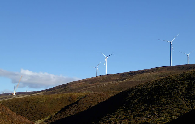
.......the north end of which hosts the turbines of the huge Dorenell Windfarm.  This has been, and continues to be, a very controversial project for a number of reasons.  The Aberdeen Press and Journal (P & J) articles make for interesting reading, as do the ones from Energy Voice.  Whatever the controversies and whatever your opinion of onshore wind energy, the simple fact is that the industrialisation of this hill has changed it forever.


I descended from Corryhabbie Hill to a boggy bealach which drains to form the River Livet on one side and the River Fiddich on theo other, thus providing the raw material for some of Scotland's best known whiskies.  The 120m/400ft turbines dominate the ridge above, the noise of those which are operating was really obvious.


I was glad to get past the windfarm and follow the Fiddich as it curved around towards my starting point at Bridgehaugh.


The final few kilometres were a joy, some warm October sunshine on my back and glorious autumnal colour around me.  I still think that this is a better route to Corryhabbie Hill than the much shorter "up and down" from Glen Rinnes - despite the visual intrusion of Dorenell.

Friday 14 December 2018

Old friends above the valley of the deer

This is the first of two "catch-up" posts from the end of October.  A bright and breezy day looked good for a hillwalk, and looking at the map I realised that it had been a while since I'd been over the hill to Speyside. I decided to climb Corryhabbie Hill, but not via the usual route.


My route from Donside to Speyside climbs up through high farmland and across the Cabrach, an area of moorland studded with mostly abandoned buildings.  It wasn't always so and there's a good history of the Cabrach on "Lenathehyena's" blog.  The play of light was marvellous on this October morning, rainbows appearing and disappearing as showers passed through.


I started my walk at Bridgehaugh where there's space to park a couple of cars clear of the estate road and entrance.  A steep slope covered with bracken was virtually glowing against a blue sky.


A look at the map in the link above will show that the track leading southwest from Bridgehaugh goes upstream alongside a river which is by no means large, but has a name known throughout the world.  This is the River Fiddich, and this view looks along part of Glen Fiddich.  Downstream the river runs through Speyside's "whisky capital", the village of Dufftown.  Along the banks of the river are some of the best known of Scotland's distilleries; Mortlach, Balvenie and, of course, Glenfiddich among them. Nowhere else in Scotland (or indeed the world) has a higher concentration of distilleries than this corner of Speyside.


I walked alongside the river past the now delapidated Glenfiddich Lodge, a former shooting lodge, and took a track climbing above a bend in the river up into a landscape of rounded hills covered in wind-clipped heather.  the track made for fast walking and I was soon swinging around between two hills and beginning the climb to the broad ridge which forms Corryhabbie Hill's summit.


From the higher ground the views open up to be really expansive.  To the north west, the most distinctive hill in the area, Ben Rinnes, is prominent.  It's a hill which has given some great days.  The "normal" route to climb Corryhabbie Hill from Glen Rinnes comes up the track in this image - my route would only coincide with that one on the summit ridge itself.


To the north, the slopes of the wonderfully named Thunderslap Hill fall to the Dullan water, and rising beyond is the Dufftown "double" of Meikle and Little Conval.  Looking to familiar hills - old friends-  is one of the small joys of hillwalking, and the more hills one climbs, the more joy there is to be had!


On the upper ridge of Corryhabbie Hill I was exposed to a biting north wind - to the north there's no higher ground between these hills and the north pole....and today it felt like it.  I stopped to put on another layer, gloves and a hat. 

Crouching down to sort out my kit I noticed the stunning colour on tufts of Deer Grass (Trichophorum cespitosum).  The name is misleading, it's neither a grass (actually a member of the sedge family) or particularly favoured by grazing deer.  The name derives from the wonderful shade of the plant in autumn, reminiscent of the coats of Red Deer.  There was a theme here too, because "Glenfiddich" is valley of the deer in Gaelic. 

Wrapped up against the chill of the wind, I walked on along the ridge.

Sunday 2 December 2018

An autumnal gem


On a crisp and sunny mid November day we drove a short distance to the pretty village of Monymusk for a walk.  Monymusk has an interesting history, the estate has been owned by the Grant family since 1712 and many of the cottages in the village square are estate properties.

Sir Archibald Grant inherited the estate in 1719 and set about transforming the agricultural land surrounding the House of Monymusk.  When the Grants took ownership the land was boggy, poorly drained, had little in the way of crop or stock capacity and was almost bare of trees.

Archie Grant had a colourful life.  He was a speculator, sometime mine owner and was expelled from the House of Commons after a financial scandal.  However, he proved to be one of the great agricultural "improver" lairds.  He ordered the clearing of ground with stones being used to make field enclosures, introduced crop rotation to the estate including the use of clovers and rye grasses to condition the soil, he planted millions of trees on the estate and was one of the early adopters of growing turnips - a humble crop today but a game changer in cattle rearing practice at the time.  Using turnips which could stay in the drill until winter, cattle could be fed through the year rather than having to be sold.  All these improvements meant a change to the old subsistence farming methods which had existed in Aberdeenshire, and many folk had to move but this was not a clearance in the sense of evicting people to make way for sheep or sporting estates.  His legacy and that of his descendants is a rich mixture of productive agricultural ground, woodland and the origins of the village of Monymusk we see today.


The most important building in Monymusk isn't the estate "big house" but the church.  A stone church has stood here since the 12th century, and it's believed that this replaced an even older Celtic church.  The origin tale concerning the building of the church records that the future King Malcolm III prayed here on his way to a battle with Macbeth near Lumphanan in 1057.  He stated that if he was successful he would build a church to replace the already old building in Monymusk. Malcolm defeated Macbeth's army, captured and summarily executed him on the battlefield, then honoured his promise to build a church.

The church seems very large for a small rural community but was originally built to serve a nearby priory.  The tower was originally somewhat higher than the present one but has been lowered twice, firstly to counteract an unsound wall.  A spire was added which in turn became unsound so the whole tower was lowered further.

The church contains an important Pictish symbol stone and two 6th century grave slabs.  Despite living just a few miles away, we've yet to see these - something to rectify!


Our walk took us out of the village and up through a wood containing some huge Douglas Firs, perhaps planted by Archibald Grant.  The path through the wood climbs gently up to Clyan's Dam.....


.......which proved to be a bit of an autumnal gem.  A path goes over the earth dam and around the small lake, which was probably a mill pond.  The last of the autumnal colours were reflected beautifully in the still water, it's a peaceful spot and several benches offer the chance to sit and enjoy the setting.


At the dam a small burn emerges out to wind down through the wood to the River Don below, rushing through mounds of beech leaves had been piled up by the wind.  We headed the same way, back down through the wood and along the minor road to reach a track which heads back towards Monymusk alongside the River Don.


As from so many places in Aberdeenshire, the distinctive shape of Bennachie's Mither Tap is prominent above the farmland and woods.


In mid November when most of the glory of autumn is finished, the Larch trees have their moment.  This image doesn't do justice to the intense yellow and gold strips interspersing the dark greens of  the spruces in Bennachie forest.  Add in a blue sky and you have another autumnal gem.

In the three weeks since the images in this post were taken a series of autumnal gales, sluicing rain and a little snow have stripped the trees of their remaining foliage.  The colours diminished, it's more about form now.


We soon arrived back at Monymusk but took a short diversion to get a view of the House of Monymusk.  Originally built by the Forbes family and developed by the Grants, it's one of the grander examples of a Scottish estate "big house" and is harled in the pink shade often used in the castles and estates of Aberdeenshire.

Our walk around Monymusk had lasted less than two hours, but on a lovely crisp day had been something of an autumnal gem!