Friday 30 January 2015

In the bleak midwinter - the icy factor


As we moved deeper into the mountains along the narrow Loch Leven the wind died to nothing.  Paddling seemed effortless, the boats gliding through the quiet water.  During this paddle we saw a total of five Otters, including one near this spot contentedly munching on a fish on the shore.


We'd chosen to do a short paddle against a 5 knot tidal stream at our starting point partially to arrive at the other very narrow part of Loch Leven, Caolasnacon (dog narrows) at nearly slack water.  The south-west entrance is marked by a wooden "perch", now  delapidated but which would have been an important navigational mark for the small vessels making their way to the aluminium smelter at Kinlochleven.

 The narrows are less than a kilometre long but quite a bit of water has to pass each way as the tide moves in and out of the upper loch; the tidal stream reaches 5 knots/10 kmh.  We knew from previous visits that we could use eddies on the north side to work back against the lesser speeds we anticipated.


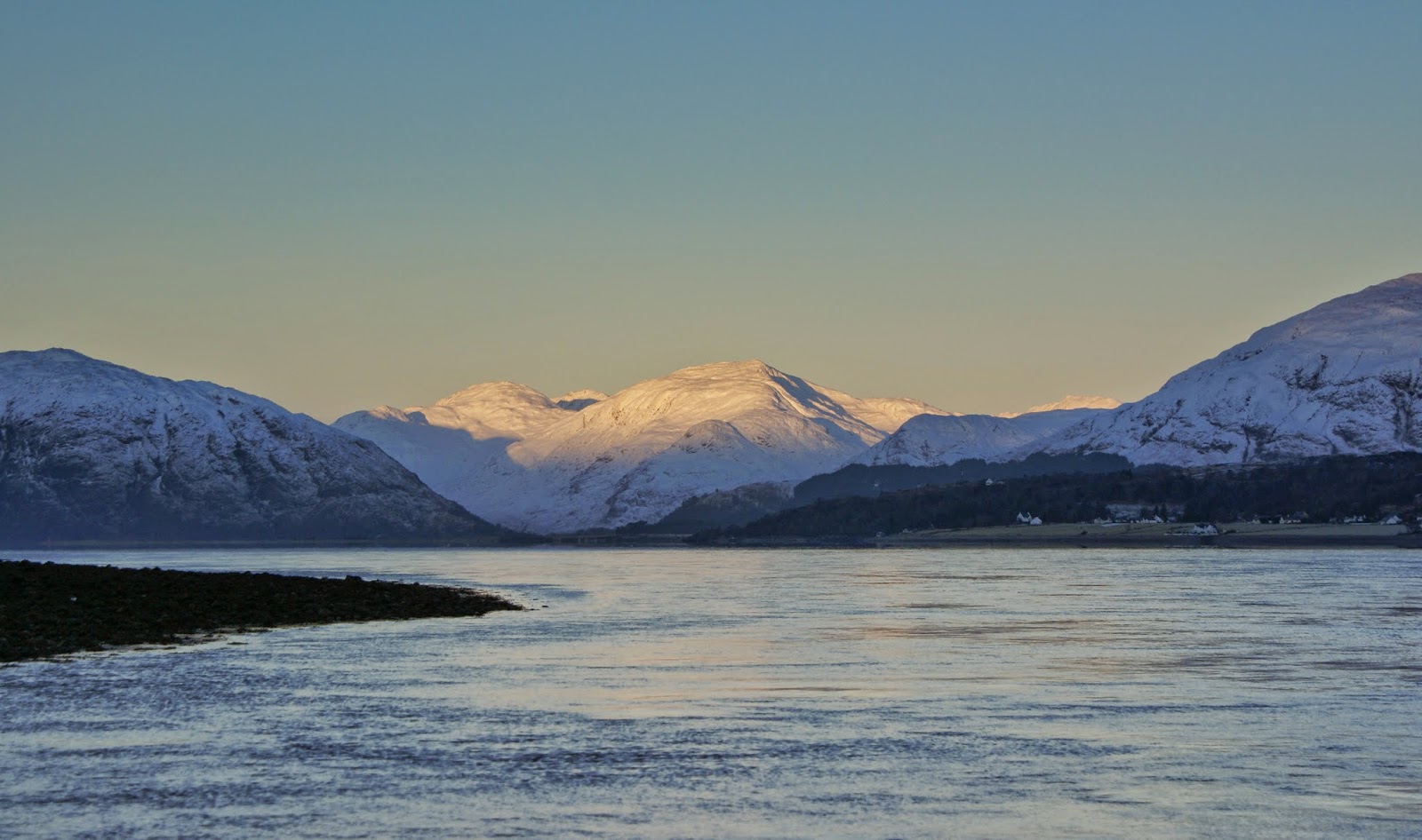
Most of the upper loch sees no sun for months during the winter as it is bounded by the high ridge of the Aonach Eagach (notched ridge) to the south.  On this short January afternoon the sun was already past its zenith but provided a spectacular "glory" blazed into a lovely blue sky.  My image doesn't really capture the effect, but Douglas has got it perfectly exposed in his photograph here


Looking back down toward the mouth of the loch it's intruiging that here, in the heart of mountain scenery and up to sixty kilometres from open sea we were paddling on salt water with a strong tidal flow.  We felt truly lucky to be experiencing such a great day; the "horse tails" of high cirrus clouds indicated a change to come.

Our own change was happening right in front of us.....


...up until now it had been merely cold; in upper Loch Leven it was truly freezing.  From the outset every splash of water on the boats had been freezing, but this ice had been easy to clear.  Up here the sea itself was freezing and any splash or drip from our paddles instantly froze to a hard, clear ice covering.

The banks were covered with silvered plates of ice formed as the tide dropped and the surface of the water had first a thin, then a thicker covering of continuous ice.


We had intended to beach the boats on the gravel flats at the head of the loch where a freshwater river was keeping the water open and walk up to The Ice Factor for a coffee.  As we approached the shore the temperature dropped even further and a shrivelling wind started up, flowing down from the mountains above.  This image is a bit hazy because the lens of my camera was beginning to freeze over....

All three of us are winter mountaineers and hillwalkers as well as sea kayakers - we're accustomed to cold conditions but this was really, really bitter.  We decided on the briefest of comfort stops before getting straight back into the boats to retreat.  We had our hands out of our pogies for probably less than five minutes, yet in that time both Douglas and I suffered some minor cold injuries to our fingers, Douglas got two numb fingertips whilst re-tying a deck rigging knot which took fully 24 hours to recover.  I got similar damage between some of the bases of my fingers.  Probably it was the stark change from hands being warm but a bit damp inside pogies to being exposed to the biting breeze, but it was a salutary reminder.


Frozen fingers and iced-up rigging probably wasn't the ideal scenario in which to put up a sail on a kayak for the first time, but the breeze did speed us away from the worst of the cold before dying less than a kilometre from the head of the loch.


We re-warmed by steady paddling, enjoying the reflections and reflecting on the cold we'd just experienced.  Clearly this required a whole new scale of reference.  Douglas came up with "zero dgrees K" - not Kelvin, but "Kinlochleven".  It's the scale we'll use from now on and we are confident that we'll not often be in minus figures!

We passed back down through the Caolasnacon and later through the islands of the lower loch, leaving a visit to the graves there for another time.  It was well after sunset when we arrived back at the ferry slipway, our paddle up against the flood far easier than our departure that morning.

It had been a truly great day's sea-kayaking in some remarkable conditions.  Days like these, they stay with you forever....

Wednesday 28 January 2015

In the bleak midwinter - drinking in the view


We were really glad to paddle from shade into bright sunshine, although the temperature remained stubbornly below zero it just felt a bit warmer.  The view across to the Glencoe hills began to open up, Bidean nam Bian on the right of this image is almost a miniature mountain range complete with ridges, summits, spurs and corries.


To the north of Loch Leven the Corbett of Mam na Gualainn rises almost from the shore and was in brilliant sunshine - it was a marvellous morning to be on the water!


My own view ahead had an unaccustomed element in the shape of a Flat Earth Kayak Sail neatly furled along the foredeck - of which more in future posts......


The prominent peak of the Pap of Glencoe ("pap" indicating a breast-like shape; the Gaelic names are very descriptive!) is one of those hills which has a presence much greater than its size would suggest.  At 742 metres/2434 ft it's really an outlier of the grand ridge of the Aonach Eagach which walls in the north side of Glencoe, but it has views to equal most of the higher mountains and is one of the most recognisable of Scottish hills.


After a couple of hours of paddling in this amazing scenery we spotted a shingle beach with some convenient rocks in full sun - the vote for first luncheon was unanimous!  As luncheon stops go, this one ranks in the first division for the superb view back across the loch to Beinn a'Bheithir......


.....we drank in the view as we drank our coffee; all of us so glad to be out paddling on this cracker of a day.  We weren't the only kayakers to be enjoying a fine winter day either; our friends Duncan and Joan had been unable to join us at Ballachulish but had siezed the chance for a paddle on Loch Tay amongst some simply beautiful mountain scenery.


We packed away and left the beach, heading up the loch with dazzling views on either side.  We knew that we'd paddle back into the freezing shade later on, but right now we just enjoyed the sunshine.

Monday 26 January 2015

In the bleak midwinter - a warm-up


After a very comfortable night in the Ballachulish Hotel we woke to a cold and frosty morning.  The routine for this and subsequent mornings was to be breakfast at 0730 and then get ready to be on the water around 0830.  At first light it was clear that the night had been cold, our boats and cars had a heavy covering of frost.


We unloaded the boats and packed ready for the day, a chilly job.  One of the advantages of staying at the Ballachulish Hotel is that we could launch almost straight from the front of the hotel on a slipway.  Despite the cold we occasionally stopped to look up.....


...as the morning sun began to touch the hills of Ardgour across Loch Linnhe.


Prominent in the view is Garbh Bheinn (rough mountain), a really fine hill which gives superb hillwalking and climbing with soaring ridges, buttresses and gullies.  The "Great Ridge" and immediately right the "Great Gully" are the chief climbing features, both pioneered by W.H. (Bill) Murray.


As the sun crept a little higher the Ardgour skyline began to glow brilliantly.  At Ballachulish, screened from the rising sun by the the bulk of Beinn a'Bheithir (hill of the thunderbolt) we were in deep shade, but about to get a lot warmer.


Our launch point was the slipway formerly used by a ferry prior to construction of the Ballachulish Bridge in 1975.  Not the most elegant of bridges, it is however an important crossing point and greatly aided road communication when it replaced the ferry.  The ebb tide was pouring through the narrows under the bridge at over 5 knots (10 km/h) and we needed to get up past the narrows into the wider Loch Leven where the tidal stream is much less. 

My first attempt at ferry gliding across wasn't successful as I just couldn't make headway.  I returned to the slipway and used an eddy under the bridge support to gain some ground then made a ferry-glide across to the north side - a strenuous paddle first thing in the morning but at least we were now all warmed up!


Once we were clear of the narrows the tidal stream became almost unnoticeable and we could take time to look back to the bridge silhouetted against the backdrop of Garbh Bheinn.


Ahead, the sunlight streamed down lower Glencoe around the flank of Beinn a' Bheithir and we paddled on towards the warmth and light.

Friday 23 January 2015

In the bleak midwinter - getting there

"In the bleak midwinter, frosty wind made moan,
 Earth stood hard as iron, water like a stone;
Snow had fallen, snow on snow, snow on snow,
In the bleak midwinter, long ago....."


Weeks of gales, one frontal system after another piling in bringing stormy and cold conditions and giving no opportunities for sea kayaking. Walking days had been restricted to the lower hills whilst the high tops were swept by 100mph winds on an almost daily basis; all very frustrating. But then, a forecast of a lull for a few days, not perfect weather but suitable for a winter kayaking trip. The residual Atlantic swell would make any trip on an exposed coast uncomfortable, so we looked for sheltered options. A couple of emails and phone calls later, Douglas, Mike and I were heading west...

But first we had to get there. Often in winter getting to the put-in is one of the trickiest parts of the venture....


...and it proved to be the case on this occasion.  Snow and then a deep frost gave very tricky road conditions as I crossed the spine of Scotland on my way west.


Many found the going more than tricky, cars stuck at various places on the infamous Lecht road, a regular feature on traffic bulletins throughout every winter.  With care I got through safely.


A brief stop at the Lecht ski area drew some puzzled glances - had I maybe packed the wrong choice of toys?!  I met up with Douglas and Mike at the very comfortable Ballachulish Hotel which was to be our base for the trip - it's not always necessary to "rough it" on a paddling venture!

We had arranged to meet early afternoon so that we could do a short hillwalk before dark, and it was to be a hill of some considerable significance


We chose to climb Ardsheal Hill, a "Marilyn" situated on the shore of Loch Linnhe.  At 263 metres/863 feet it gives a short climb with a view out of all proportion to height.  But the significance of this hill to us was neither the height nor the view.  After a series of major operations on both knees and on a shoulder, any one of which would have finished the outdoor adventures of someone with less determination, this was the first hill walk  Douglas has managed in a few years.  His smile was as wide as the view at achieving a return to the hills - he's most definitely "getting there"! Mike and I were absolutely delighted in being able share his successful ascent.


The view west from the summit of the hill along Loch Linnhe was superb, the forecast for the following day was great and we had a fine dinner ahead of us at the hotel - we were definitely getting there :o)

You will be able to follow our trip in "sea kayaking stereovision" (and with much better photographs than mine!) by reading Douglas' blog, starting here

Saturday 17 January 2015

A Fare day


A cold day with an even colder wind - it's been the way of things in the north-east of Scotland for the last few weeks.  Too windy for kayaking, too windy for practical days on the higher hills but perfect for days out on the lower hills.

The Hill of Fare is a sprawling, rolling area of heather moorland overlooking Banchory on Deeside.  The "normal" route goes up from Raemoir to the south of the hill and is quite short; the far longer but (in my opinion) far finer route goes from the east of the hill near Echt, offering a spacious feel and wide views for almost the entire way.

On setting out from the road I found that I'd left my camera at home.  The I did have my smartphone though, a Samsung Galaxy S5 and so I took the images on that - and on the whole I was quite impressed with how they turned out - it is a phone after all!  This view shows the ever-present Mither Tap of Bennachie on the right, and Cairn William with good snow cover on the left.


Emerging from the forest one is straight away onto the broad shoulder of the hill.  There are good tracks right across the high ground and with good snow cover this may well make a good ski tour.


Pausing for breath in the frigid cold air, I looked back to a super view right over the city of Aberdeen and out to the North Sea - I could clearly make out ships anchored off the harbour.


Although less than in most years, the snow cover enhanced the landscape enormously and the all-round views  were really good.


To the west the higher Deeside hills were intermittently under sweeping snow-showers, emerging each time a little bit whiter than before.


The summit of Hill of Fare (a "Marilyn" and 471 metres/1545 feet high) is not where the name appears on the map but about 2 kilometres to the south-west.  The actual top is marked only by a boulder and a couple of smaller stones; in poor visibility or under deep snow it would be a challenge to find.  The outward route is a full 10 kilometres, as would be my return, but the views more than made up for the distance - a hill to save for a "Fare" day.

Thursday 15 January 2015

Grabbing the chance, grabbing the planks

Winter in the north east of Scotland thus far has been characterised by rapid weather changes as deep Atlantic low pressure systems sweep across the country from west to east. There hasn't been the rain and damaging storm gusts which the western seaboard and Northern Isles have endured, it's just been cold, windy and very changeable. So when an overnight fall of snow seemed to have offered just enough snow.......


...the opportunity of a couple of hours on ski wasn't to be missed!   The forest tracks locally can be very good for XC skiing, having nice easy gradients and a good surface.


There was just enough snow, and it was just cold enough to allow a reasonable kick-and-glide, though the snow cover was thinner in parts exposed to the wind and required a few hundred metres of walking.


The view down to home showed that this was just a light snowfall and it was forecast to disappear as the air warmed above freezing during yet another frontal passage.


It was good to be able to grab the chance even though it was a pretty short trip - and on the way back down my outward tracks made for a reasonably quick and aerobic run :o)

Wednesday 14 January 2015

Putting the boots on Aigan


Viewed from Little Conval, the nearby hill of Ben Aigan is quite prominent and, since it was early enough in the day, I hoped to climb it on my way home.  After driving the short distance from Dufftown to the Forest Enterprise car park at the foot of the hill I set off in less than promising conditions.


The morning sunshine had been replaced with overcast sky and as I set out it began to snow quite heavily.  Where the Convals are heathery hills with open views, Ben Aigan is hemmed in with forestry on all sides which extends near to the summit.  A subsidiary top also sports a large transmitter tower which is at least a reference point among the trees.

Unusually, I found myself not really enjoying being out on the hill, especially after taking a wrong turn on a wet forest track.  I had a quiet word with myself - I'm very fortunate to have the time, location and health to do these things!  Perhaps it was a combination of being a bit cold from starting out again after being in the car, or just a bit of tiredness....


....and as I climbed higher and warmed up a bit the view began to provide interest - surely few hills can have as wide a view of the Moray Firth, stretching from Findhorn past Lossiemouth to Spey Bay and Cullen, it's a grand sweep of the coast.  Below, the River Spey winds like a silver ribbon from whisky country to the sea.


Ben Aigan is a fairly short ascent and I was soon onto the gently domed summit which sports a trig pillar which is unusual in being rectangular shaped. At just 471m/1545ft, it's certainly not a big hill but it does have a big view.  My earlier grumpiness was completely gone, blown away by the view and the wild wind.


I was very glad I'd put my boots on again, on Aigan!

Monday 12 January 2015

A Speyside "double" - the last drop


After descending from Meikle Conval to the bealach (col) separating the two hills, it's a short and straightforward climb to the summit of Little Conval. Near to the summit itself are the remains of a hillfort, the visible remains are tumbled walls and the hint of a trench.  The date of the fort is prehistoric, but uncertain beyond that; one thing won't have changed at all though - it would have been a windy spot!


The view to the west from the summit is into the heart of whisky country and right below the hill is Benrinnes distillery, one of many I could see from here.


The trig pillar on Little Conval is about 100 metres north and below the summit itself, a position which has a much wider view than the domed top of the hill.  There's a good view of Ben Aigan a few kilometres to the north, and I hoped to climb that hill later in the day......


...but first I had to get back down to my starting point in Dufftown.  the path I took skirts the top of the golf course and requires some picking through rough ground and a wood lower down, a better option would probably been to have gone back down to the bealach separating the Convals and to have taken the track following the pylons to the road.


But no matter, I was back in Dufftown for lunchtime and savouring the last drop of the view of Little Conval from the town.

Friday 9 January 2015

A Speyside "double" - the first sip


A 45 minute  drive from home saw me in Dufftown in the heart of Speyside's whisky country to sample my own "double"; the hills of Meikle Conval and Little Conval which are well seen from the town.  The weather was bright and cold but a rapid increase in the strength of the wind to violent storm force was forecast for the evening so I wanted to be well home before it got too wild.

Dufftown sits at the confluence of the Dullan Water and the River Fiddich and is surrounded by well-known distilleries such as Glenfiddich, The Balvenie and Mortlach among others.  In fact, there are so many distilleries and bond-warehouses that it's claimed Dufftown raises more revenue for the government per head of population than anywhere else in the UK!


Due to the forecast westerly winds I wanted to walk the higher ground from west to east in order to have the push at my back rather than slogging into a gale.  This conveniently also meant that I'd have the sun at my back too.  A relatively new path, part of the local path network runs alongside the B9009 road for part of the way to the start of the track up Meikle Conval, though in summer the road is quite busy.  On the way I passed Dufftown Golf Club, one of the highest in the country.  The second of the hills I was aiming for, Little Conval, can be seen above the golf course.


After a few kilometres of road walking into a stiff breeze I approached the base of Meikle Conval (big conical hill).  A straightforward climb up a vehicle track gives access to the domed summit area, when I was quite suddenly exposed to a blasting westerly wind which was as cold as it was strong, but also exposed to a great view.....


over to the Corbett of Ben Rinnes  , a fine hill visible from a wide swathe of the north east of Scotland.  If it was windy at a modest height of 571 metres (Meikle Conval is a "Marilyn"), the cloud banner tearing off the summit of Ben Rinnes indicated that it would be even more windy up there - and that this was definitely not a day for the higher hills.


I didn't linger but headed off over towards Little Conval, having to "lean on the wind" as it was behind but also to my left side as it compressed around the shoulder of Ben Rinnes - but what a fine, wild day it was to be on the hill for a whisky country "double" !