Showing posts with label Isle of Eigg. Show all posts

Monday, 1 July 2019

A cinematic event at Shoe Bay


From our camp at "Shoe Bay" Douglas and Tony climbed a nearby rocky hill to watch the evening's cinematic entertainment.


The show began as the spotlight came up behind us......


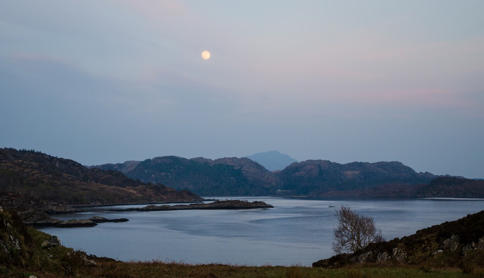
...and cast a lovely pale light over Loch Moidart.  Beyond the loch, Beinn Resipol seemed almost translucent in the evening light.  But the rise of the full moon was just the curtain-raiser - the main event was underway in the opposite direction.


...as a smoky sunset coloured up the western sky.  As it set beyond the low outline of Muck, we speculated as to whether the sky would develop into technicolour shades or not.


A little further along the horizon, the silhouette of Eigg sailed the western sea - it's always reminded me of the outline of a ship.  Eigg and Muck have given such superb days, whether on the sea or on foot - they really do feel like old friends I'm privileged to have an acquaintance with.


There would be no technicolour blaze across the horizon on this evening, but we weren't complaining....every sunset is subtly different and this one was a slow, smouldering affair.


Below the rocky perch I'd chosen, the sand of Shoe Bay turned ghostly pale in the evening light and the colour of our boats seemed to really glow.


We created our own blaze and glow as the evening progressed....sitting around our fire and reflecting on just how fortunate we are to be able to experience evenings such as this in special places like these.

Thursday, 9 August 2018

A crossing from Eigg and the colours of summer

We had a leisurely start in our camp at Kildonnan, there was a strong north easterly breeze blowing as we ate our breakfast but the forecast was for the wind to drop as the morning went on.  We had a back-up plan which involved taking the lunchtime ferry to Mallaig if the wind remained strong, though we were very much hoping to complete the journey back to the mainland under our own steam.


The forecast was accurate and the wind had dropped markedly by mid morning.  We got underway and headed out from the shore of Eigg, knowing that it's an island we'll return to.


The conditions were just about perfect for sea kayak sailing - we hoisted our Flat Earth sails and felt the immediate increase in speed as the sails filled and began to pull strongly.  The was a short chop in some areas as the tide swirled up the Sound of Arisaig which only added to the fun........


....and we weren't the only ones enjoying the conditions.  This fine traditionally built yacht was absolutely spanking along and we got a cheery wave from her skipper.

The wind dropped to a very light breeze as we neared the Arisaig shore and we once again felt the full heat of the midday sun.  We were aiming for the beach at Port nam Murrach which had been the jumping-off point for our outward crossing two days previously.  The enclosed channel is quite difficult to locate from seaward, but a GPS waypoint kept us straight.....


....and we were soon cruising in to the idyllic little beach with jade green water beneath our kayaks.


The clarity of the water in this bay always delights, the colours change with the state of the tide and the reflection of the sky. Eigg is prominent in the seaward view, some 14 kilometres across the Sound of Arisaig.  With the assistance of our sails the crossing had taken a little over two hours without undue effort.

We were pleased to have been able to paddle out to Eigg, circumnavigate the island, climb to its highest point and then to paddle back to the mainland. Our journey wasn't over, but we now had a the remainder of the day to spend cruising the Arisaig coast, and we planned to spend an further night on the journey too.


In contrast to the morning we set out to Eigg we had the beach at Port nam Murrach to ourselves.  We enjoyed a leisurely luncheon stretched out on the cropped turf above the sand, absorbing the atmosphere of the place.  The machair  and rock outcrops were studded with the bright colours of early summer flowers, so we took some time to just stroll around and enjoy them.


Thrift (Armeria maritima) was at its very best, the seemingly delicate flowers nearly all open in the bright sunshine.  This is one of my favourite wildflowers, it's equally at home on salt-lashed shorelines and right to the summits of our mountains - a truly tough little plant.


Three different plants in this image,  the tiny purple flowers are Wild Thyme (Thymus polytrichus) - the leaves of which can be used to add a lovely flavour to camp food.  The yellow flowers are Birdsfoot Trefoil (Lotus corniculatus) which hadn't fully formed the red buds which give it the alternative name "Bacon and Egg plant".  Between the two, a White Clover (Trifolium repens), a useful fixer of nitrogen in soils.  All these plants are favoured by bees and hoverflies and we saw some of the mining bees for which this site is known feeding on the flowers.


This tiny succulent plant was growing in amongst the boulders - I think it might be English Stonecrop (Sedum anglicum) - but I'm not at all certain. 


I'd been mildly surprised that there was nobody else at this popular spot, and as we put our lunch things back in the boats, a guided party of kayakers arrived.  They'd paddled out from Arisaig and had been enjoying seeing the seals among the skerries in Loch na Ceall before heading down to Port nam Murrach for lunch.  What better introduction to sea kayaking could there possibly be to padle in a stunning location with great wildlife, calm seas and dazzling beaches?!


Mike had joined me in searching the shore ...... and we were delighted to find a few "Groatie Buckies".  There's a risk in finding one though; as those who paddle with me will know, hours can pass while I indulge in this addictive pastime! Having found a couple each to add to our jars of these lovely little shells, Mike managed to persuade me that it was time to go.....


In the space of about 30 minutes while we'd been intently looking at the sand in search of shells there had been quite a change in the weather.  A cloud sheet had formed, the breeze had disappeared completely and the air felt heavy and warm - it seemed that there might be some thundery weather.  We discussed possible spots to camp for the evening and decided to dawdle along the coast of the Sound of Arisaig towards Loch nan Uamh to assess a couple of places we've used previously.

Tuesday, 7 August 2018

Eigg time at a Kildonnan camp


This image, taken on our ascent of An Sgurr, shows most of the way down - across the moor then down through farmland and woods to Galmisdale which is to the right of the pier.  We went down quickly even though we were sweating profusely in the afternoon heat. We passed a couple of other parties on the way down, who must have wondered what all the rush was about......


.....until they arrived back at the Galmisdale Cafe and Bar and found us resting in the shade with containers of chilled sports recovery drink!  We felt that the level of dehydration merited two such containers apiece, after which we headed over to our boats, unpacked and pitched our tents.

Camp established, we wandered back to Galmisdale.  As well as a cafe and bar, there's a shop, a craft shop and information hub plus toilet and shower facilities and an outside tap to fill water containers. There's free wi-fi in the immediate vicinity of the building which is very useful for obtaining up to date weather forecasts as mobile phone coverage is somewhat patchy here. The toilets and showers are accessible 24 hours, there's an honesty box with a suggested donation for use of the showers which we were very happy to pay.

We collected a couple more sports recovery containers prior to the shop closing and walked back around to our camp.


The old part of the harbour has some craft moored up which have definitely seen better days.  Remarkably, the old passenger launch still floats, rising on each tide before settling back at low water.  The lines of this launch looked familiar, it was only after returning home and reviewing my images that I realised she is (or was) an Admiralty Harbour Launch Diesel (HLD), similar to this one.  A design which remained unchanged for decades, the HLD's were timber built, 52 foot launches powered by a Foden FD diesel engine and were used for transporting personnel around dockyard ports - I must have travelled on several of them over a period of time.


Mike and I spent a most pleasant evening at our camp.  Dinner was cooked and eaten, accompanied with the previously obtained sports recovery drink with a view across the Sound of Arisaig to the hills and sea lochs from Mallaig to Ardnamurchan.  A north easterly breeze picked up again during the early evening, keeping the midges away nicely.  We voted to postpone a decision on the following day's activity until the morning weather forecast and simply took our ease, enjoying the situation and the view.....we were operating on "Eigg time"!

Sunday, 5 August 2018

Fried on Eigg

After enjoying lunch and checking out the facilities at Galmisdale Mike and I returned to our boats and paddled a couple of hundred metres round to the bay which is recommended for yachts to anchor and for informal camping


I knew from a previous visit that the ground behind the bay is also used for grazing sheep and cattle - and sure enough some of the cattle were cooling themselves in the water when we arrived on the beach.While we felt that they'd have seen it all before and would be unlikely to bother us, we felt t wise to leave everything in our boats rather than pitching the tents straight away in case one of the younger beasts got curious....

Having used a trolley to half pull and half carry each boat up the soft sand, we got changed into shorts and light shirts for a bit of a walk.  We each had an ultralight rucsac in our boats and packed these with water, some snacks, a long sleeved top and sun cream....good to go.


Heading up the track back towards Galmisdale, we found where the sheep normally on the machair had gone......everything on Eigg is dual purpose where possible!  These ewes had the right idea, at just gone 1pm the heat was pretty full-on, and they still had thick fleeces.


At Galmisdale there's a sign board detailing waymarked walks, with each walk having a colour code.  The coloured waymarks are a bit sketchy to find - if, like us, you want the quickest route to climb An Sgurr, take a track up through some pretty woodland, then follow a rough track across open pasture to reach a gate near this house.  The route then goes left beyond the house and then immediately right - not that obvious but once on the hill path, very straightforward.

This must be one of the most photographed views of An Sgurr, it has a nice composition with the house giving some foreground - and is also a good place to pause on the first of the steep slopes!


There really isn't much doubt which way the wind blows here.  This tree, unexpectedly it's a Beech, was older than its size suggests, cropped and sculpted by the wind.


The climb towards An Sgurr is steady and uncomplicated, just a couple of rocky steps on the crossing of a moor which laps the base of the prow - which gets steadily more impressive as you approach.

The Sgurr is the southern termination of a pitchstone ridge which runs along the spine of Eigg.  Formed during the birth of a huge volcano complex which included creation of the island of Rum, it is effectively a mirror image of the landscape of 58 million years ago.

Pitchstone is formed from viscous lava flows and is tougher than the usual basaltic lavas.  The story of the Sgurr ridge is this:

As the Rum volcano complex erupted, a layered basalt lava flow landscape emerged, covering the ground to the level of the present day ridge.  Over time (about 6 million years), a valley was eroded out of the basalt lavas, and when the pitchstone lava was erupted it filled this valley to the brim. Because pitchstone is so much harder than basalt it resisted erosion as the basalt around it was worn away, so what you see today is an inverted valley, like a jelly-mould image.  There's a good explanation of the process in this paper by the JNCC.


As we crested the slope at the base of the great prow, the view opened to Rum, the source of all the lava. From an elevated viewpoint the vague shape of the Rum Main Ring Fault can be seen in the hills.  Our route contoured along the north flank of An Sgurr to climb though a fault line and emerge onto a shallow col.....


....where the view to the south is suddenly revealed.  The long finger of Ardnamurchan is in the foreground with the west coasts of Islay beyond, fading into a heat haze.


The route now switches to the south side of the An Sgurr ridge and follows a narrow path with a little bit of exposure and stunning views.  Below our feet was the coast we'd paddled that morning, out to sea lies Muck, our original target for the day.  Beyond Muck, faintly discernable in the haze we could see the outline of land - and puzzled for a few minutes about where this might be until Mike correctly identified Coll and Tiree - islands I've yet to visit.

It was clear that the wind had dropped considerably, and that we'd probably have been able to get to and from Muck safely - but what we'd missed in visiting Muck was being amply compensated by this brilliant hillwalk.


Cresting the ridge, we got a view down to Galmisdale and the route we'd walked to get up.  We could clearly see the narrow finger of turf where we would camp, just below the dark coloured skerry in this image.


To the north, the previous night's camp at Bay of Laig was visible at the same time, and the view leapt across the Sound of Rum, now an intense blue.


The final few metres to the summit track across the surface of the pitchstone, showing some of the columnar shapes formed as it cooled.  Right now, it felt like the lava was still warm from the volcano - the heat was terrific and was being reflected up from the rock in pulsing waves of dry, hot air.


On reaching the summit, we flopped down and spent a good half an hour just taking in the views and the situation.  At 393 metres/1289 feet An Sgurr is quite a small hill, but it has a view matched by few other hills in Scotland.  The combination of islands, mountains and lochs forming a true 360 degree panorama are simply stunning.

We left the summit reluctantly - it would have been easy to while away hours up here but we were being absolutely scorched by the sun and had limited water with us.  Truly, we were being fried on Eigg, and would be "sunny side up" for days afterward.

We went fast and direct on the descent - for we had a powerful incentive.....


Wednesday, 1 August 2018

Out of the blue - Bay of Laig to Galmisdale


We woke to a sparkling morning, the view of Rum from our camp at Bay of Laig was very fine.  Mike and I had landed the previous evening at just about high water and so didn't have far to move the boats.  Over breakfast we watched the morning high water come and go - handily it wasn't far to move the boats back into the water.


Where the evening view of Rum was a silhouette backed by the sunset, the morning view is flooded with light, showing the features of the island.  We picked out each of the grand, Norse-named hills - from left to right are Sgurr na Gillean, Ainshival, Trollaval, Askival, the highest of Rum's Cuillin, and Hallival.  We were able to clearly pick out Glen Dibidil, enclosed by rugged ridges and at the left of the view the cliffs of Sron na h-Iolaire.

Sat around our fire  the previous evening we'd discussed various options for the rest of our trip.  We had another two nights available before both of us had commitments, and this helped us in deciding that a circumnavigation of Rum would be too long a route.  Even if we took the ferry from Kinloch to Mallaig we'd still have a further day's paddling back to our cars at Glenuig.  We also considered an out-and-back to Harris Bay on Rum's west coast but to both of us this seemed like making the crossing simply for the sake of it.  I've yet to paddle the west coast of Rum, but it'll wait until the time is right.

Some trips require detailed planning due to tidal constraints or weather conditions - but on this one we could be much more flexible.  We'd deliberately set out with no fixed itinerary other than a crossing to Eigg.  If the weather forecast changed dramatically we could simply use the ferry back to Mallaig and work back to Glenuig, otherwise we'd go with what seemed best at the time.  The settled conditions in the early morning looked good for a crossing to Muck, so that was what we decided on.


Heading out from Laig opened up the view to the north where the Black Cuillin of Skye floated above a sea mist.  We picked out individual peaks, re-living great days and hard battles on that amazing ridge.


From Bay of Laig there are no tenable landing places for 12 kilometres along the west and south coasts of Eigg; cliffs fall to jumbled boulder shores or straight into the sea.  Conditions were absolutely perfect to get close in and exploring this dramatic section of the island.


Buttresses, caves and crags are the predominant scenery here and we were treated to great views.  The warm sunshine, clear visibility and flat sea was quite a contrast to my previous journey along this part of Eigg, when Douglas and I were entranced by shifting mist and tantalising glimpses of great walls of rock on a winter journey in the Small Isles.


The low outline of Muck became visible as we headed around the coast, conditions were still good and we were looking forward to crossing with  a bit of sail assistance from a north easterly breeze which had started up.  Taking a bearing to keep us on track, we agreed the target as Gallanach Bay and hoisted our sails to begin the crossing.

We were soon spanking along as the breeze freshened a little, our boats surging forward under sail.  The breeze continued to freshen though, a smooth acceleration in wind speed up through Force 2 to 3, then to 4.  Mike and I made sure we were in close formation whilst enjoying this exhilarating ride down wind and sea, spray bursting from the bows of our boats - there are no photographs from this period as both hands were definitely needed on the paddle!

As the wind had reached Force 4 I'd been doing some thinking about the conditions.  A north easterly wind would quickly build a swell running onto Muck, and I knew from previous experience that Muck has reefs all around which amplify any swell.  Furthermore, a north easterly would be blowing directly from Eigg and would make returning from Muck a real slog.  We hadn't been able to get a forecast either from the Maritime Safety Information broadcasts on VHF or from Radio Scotland as there was no reception at Laig Bay - so we were working on a forecast from almost 36 hours previously.

Gradually, my internal alarm bells started ringing.  I've developed a healthy respect for winds from an easterly component which blow from clear blue sky in high pressure conditions - they have led to some of my toughest battles on the water.  The wind, now touching Force 5, was continuing to strengthen and both Mike and I dropped our sails as the power going through them was terrific with our boats laden with camping gear.  At that moment the VHF forecast was announced and we listened to it with full attention.  Winds of Force 5 or 6 from the northeast, then east were forecast - which settled the matter.  We turned about and battled back towards Eigg.  We had got just about half way to Muck and could already see the line of surf right along its coastline - a landing would have been quite sporting and getting off difficult if the wind continued as forecast.  It was a mighty struggle to get back to Eigg's south coast, the wind was pouring off the island as a steady, insistent force.


Eventually we won back close under the shore and in the wind shadow of the An Sgurr ridge - it was like a different world with just a light breeze.  Out to sea, the glittering surface was full of whitecaps - we felt we'd made the right decision.


Above us, the great ridge of An Sgurr was picked out in sharp detail by the morning sun, a dramatic sight....and we began to form an alternative plan for the day.........


......which first called for us to head for Galmisdale, Eigg's main settlement (but don't expect a busy town!).  Pulling our boats up on the sand opposite the pier, we got by a friendly reception from a dog who clearly felt that sea kayakers arrived here simply for him to play with.  Having carried the boats well up the sand, we noticed that we weren't the only paddlers in town.


Two boats sat at the top of the beach, meaning two paddlers with almost certainly  the same intention we had.....


Mike and I strolled over to the Galmisdale Cafe where we ordered lunch - and we can report that the home-made burgers with salad and hand cut chips are simply superb!  Over lunch, we finalised our revised plan for the day which would involve very little sea kayaking, but quite a lot of walking.

Friday, 27 July 2018

Laid down at Bay of Laig


The west coast of Eigg is just as spectacular as the east side, great cliffs providing a backdrop to the shoreline. We had a spot in mind to camp and paddled steadily southward towards it.


A party of kayakers had set up camp on level ground above a boulder beach - a great location with a good view, but neither Mike or I thought it would make a good landing or launching spot with heavy boats, and would be difficult to leave if the swell got up on this exposed coast.


Our firs option for camping was at Camas Sgiotaig, but as we rounded the point which forms the north side of the bay, we became aware of a low but powerful groundswell pushing up the Sound of Rum from the open Atlantic.  The swell was roaring across the reef of Bogha na Brice-nis - which I didn't capture very well in this image.  We were already noting that the swell direction was straight into Camas Sgiotaig when we spotted that a lone kayaker was already camped on the shore above the beach.  A slight concern for the swell combined with not wanting to disturb an idyllic camp for someone else made our decision - we would push on a little further to our second potential camp,with the option to return here if necessary.


A couple of kilometres further on we landed at Bay of Laig in flat calm, the swell wasn't reaching around into this bay.  It had been a long day of paddling, some 36km and nine hours since leaving Glenuig, but what a great day it had been.  We quickly found an ideal camping spot and pitched our tents before the slight breeze died completely and the first midges we'd seen this year came out to play - the warning of the Yellow Flag Iris had been correct!

The houses in the distance are at Cleadale, and I was able to pick out Lageorna, the wonderful B&B which Douglas and I had stayed in on our winter trip.


As the sun set, the outline of Rum was reflected in beautiful shades below a soft cloudscape, just lovely.


We gathered a little driftwood to add to some logs we'd brought with us, and with the use of a Wilcox Ignition Aid(TM) we soon had a fire lit, the smoke going some way to deter the midges. 


We lit the fire well down the beach to avoid any risk of stray sparks igniting the tinder-dry ground; and due to the location of our other camps on this trip it would be the only fire we'd light. Fire lit, sports recovery drinks to hand and dinner consumed, life was particularly agreeable -  the midges even gave up after an hour or so to allow us out of our protective mesh jackets.


Our last view before turning in was the faint afterglow of a sunset reflecting on the wet sand in the late evening dusk.  I was asleep almost as soon as I lay down and slept soundly in this wonderful spot.