Wednesday 31 October 2018

A loch within a loch, an island within an island


The combination of sunshine and cloud seemed to intensify the colours in the trees along the shore of Loch Maree as I paddled slowly back out to the islands.


Between the islands there was no wind at all and the reflections were absolutely pin-sharp on the dark water of the loch. After paddling through a narrow gap between two small islands I aimed straight for the largest of the group to land and explore a little.


It took a while to get through the waist-height heather to find what I was looking for, a location which if not immediately spectacular is quite unusual.  On Eilean Subhainn there's a lochan with two tiny islands in it - difficult to see the one in this image.  What makes this an unusual place is that here on  a loch there's an island, which itself has a loch with an island in it!  I don't know of any other place in Scotland where this can be found.  Eilean Subhainn is the second largest freshwater loch island in Scotland, only Inchmurrin on Loch Lomond is bigger.  If you land and force through the heather to the lochan, check yourself for ticks afterward - even at this late stage of the season I picked up two tiny ones on my arm.


Back on the water and I wound my way through some more of the islands - you can easily spend a full day exploring here and not paddle the same bit of water twice.


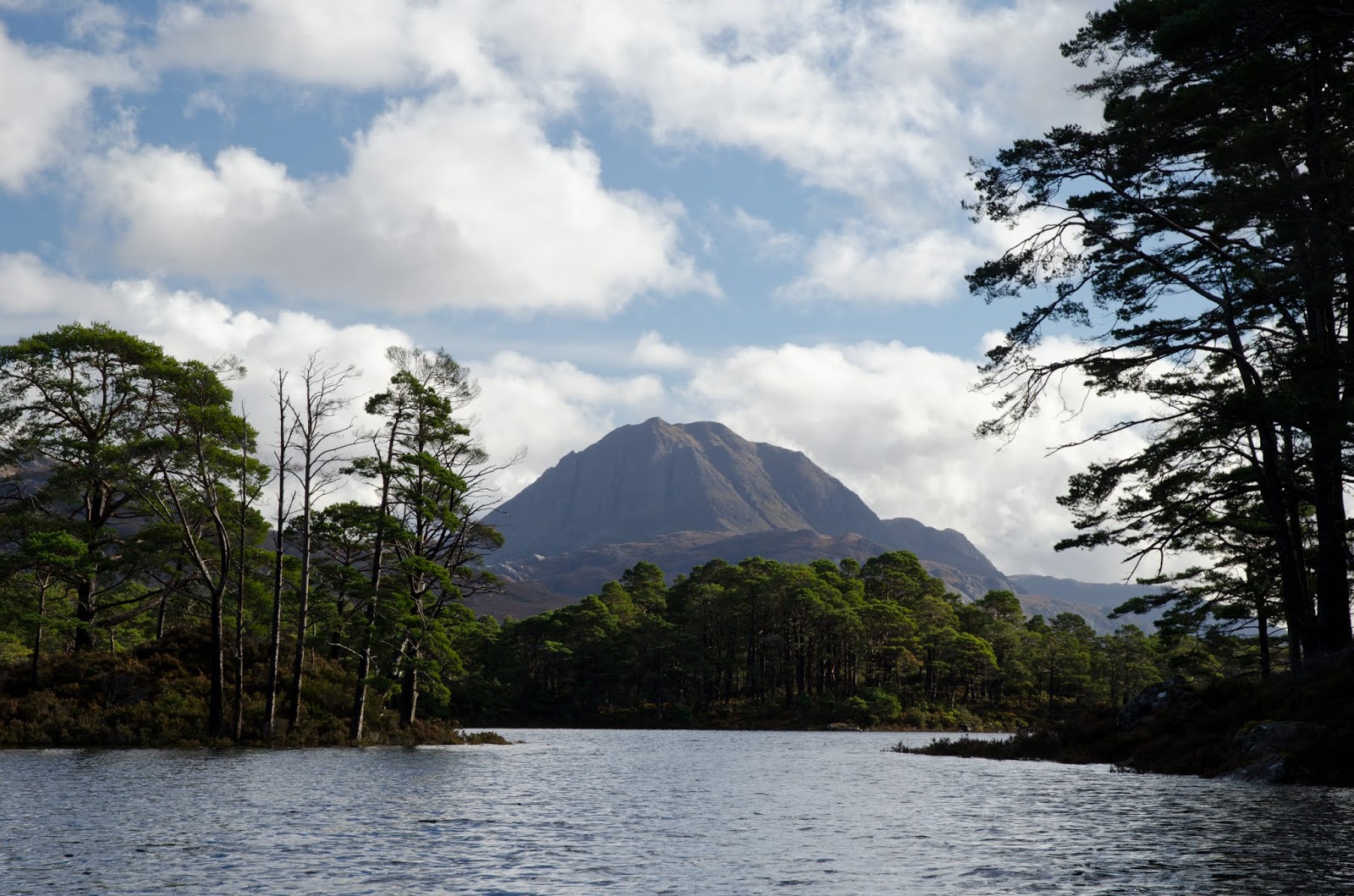
Emerging from between two of the islands, a great view opens up to the wild hills of Torridon - hills of great distinction which have given me some great days; and i's been too long since I climbed them!


Heading back to Slattadale I nosed the boat in to the burn flowing from Loch Garbhaig (loch of the rough place) over the "other" Victoria Falls - so named because Queen Victoria was taken to see the waterfall which drops over a small crag into a gorge.


I arrived back at Slattadale in lovely late afternoon sunshine.  Having unloaded the boat and put it back onto the car I had plenty of time to make a cup of tea and sit watching the play of light and shade on Slioch - and reflecting on a really good day's fresh water kayaking.

Thursday 25 October 2018

The penny drops on Isle Maree


Following a stop for second breakfast I headed back among the islands of Loch Maree.  The improving weather had extended to the length of the loch and the flanks of Slioch (the spear) were now lit with morning sun.


My next planned stop would be on Isle Maree, perhaps the best known of the loch's islands, but by no means the largest.  The closest island to the north eastern shore, Isle Maree differs from all the other islands in being wooded mainly with deciduous, rather than pine trees including some very old stands of oak and holly.

Isle Maree has a long history of usage as a ritual site; it seems to have been used for the pre-Christian tradition of sacrificing a bull - which reportedly continued into the 17th century; the crags on the northern shore are named Creag an Tarbh (crag of the bull) which recalls this tradition.  In the 8th century a chapel and hermitage was established by St Maelrubha, centred around a well. 


A very ancient wall encloses a graveyard on the highest part of the island.  Some of the gravestones are very old and there are two grave slabs incised with crosses which date from the 8th century.  It's a peaceful, atmospheric place in which to spend a little time.


One more modern memorials is a broken cross stone with very fine carving which sits in a prominent spot - but seems a little out of place among the more modest graves.  Nearby, and not so easy to find is a relic of the pre-Christian tradition here.


An oak tree has been used for centuries as a "wishing tree" - where people travelled to the island specifically to hammer in a coin as an offering, in the hope of curing illness or fulfilling a wish.  The oak tree died hundreds of years ago due to copper poisoning from all the pennies driven in, but the tradition persists.


I found the tree difficult to find, because a nearby Horse Chestnut tree has come down in the gales which raged across Scotland in early October and landed on top of the wishing tree - I reported this to Scottish Natural Heritage who were hoping to get out and assess what could be done.  If trying to locate the tree, look to the south west of the graveyard.


I'm fortunate to enjoy good health, but two of my good friends are experiencing significant health issues, so on their behalf I tapped in two copper coins, with a wish for full recovery for them both.  Traditionally the island was associated with curing insanity - but I didn't have a third coin for myself!

The tradition warns against taking anything, even a pebble, from the island in case the insanity or illnesses are brought away as well, so I didn't keep to my own habit of taking a small pebble from the landing place.

Isle Maree is one of those very special places where the long spiritual traditions seems to add to an atmosphere of peace and tranquility - I left the island feeling noticably calmer.


Back on the water, the weather was developing; on the north eastern shore all was colour and bright sunshine.....


...while to the south west impressive shower clouds were building over the hills of the Flowerdale Forest.  It was turning into a wonderful day to be out on the water.

Tuesday 23 October 2018

Autumn's glories on Loch Maree


After what has been far too long, due to either work commitments or poor weather, I planned a day kayaking - but on this occasion not sea kayaking.  Mid to late October sees the very best of the autumnal colours in Scotland and I wanted to experience the colour show from the water.

A drive across northern Scotland on an early morning brought me to the head of the road which snakes down Glen Docherty to the small village of Kinlochewe.  The prefix "Kin" is an anglicisation of the Gaelic Ceann, indicating the head of a loch or glen.  Kinlochewe is a bit of an anomaly, because the village sits not at the head of Loch Ewe, but at the head of Loch Maree.  Loch Maree is drained by the River Ewe which does lead to salt water in Loch Ewe - confused?!


It had been a grey morning all the way over from Aberdeenshire but the forecast was for clear skies and sunshine - and sure enough as I got ready at Slattadale on the shore of Loch Maree the cloud sheet was peeling away.


During the previous days Scotland had seen a real east/west weather split with truly torrential rain deluging the western side of the country while the east remained fairly dry.  Such was the volume of rain that Loch Maree was a good way above its usual level - by some half a metre. 


I headed out to the nearest of the islands which are such a feature of Loch Maree, and into a seemingly drowned landscape where one could paddle among the bases of tall pines.


The other great feature of Loch Maree is the grand backdrop of Slioch (the spear), one of the most prominent Munros and adding so much to the character of Loch Maree. The clearance in the weather hadn't yet reached that end of the loch and Slioch was just emerging from cloud, backed by a solid grey wall.


Add in the pines of the islands and you have a quintessentially Highland scene.  I set out to paddle through, around and among the islands as my route for the day.


There was real warmth in the sunshine and with no wind it was turning into a beautiful autumnal day.  Thus far the colours had been predominantly the rich dark green of the pines and the warm brown of the hillsides.......


.....but that all changed as I passed around the outside of the islands and the view to the north eastern shore opened up - a riot of gold and yellow with the russet of bracken below; just stunning.


On the opposite side of the loch a searing brilliance of sunlight rendered everything into silhouette.


Amongst all this dazzling light and scenery, I found a lovely spot to land and enjoy a leisurely late breakfast.

Monday 15 October 2018

The way back from Carn Bhac


Climbing onto the broad ridge which leads up to Carn Bhac (cairn of the peat banks) a wide view opens up to the Perthshire hills, with Beinn a'Ghlo prominent.


The first top reached is called Geal Charn - the white cairn - and although it didn't appear so under lowering cloud, the quartzite rock here appears very pale under most conditions.


From Geal Charn there's a gun-barrel view down the remarkably straight trench of Glen Tilt, one of the great through routes of the Highlands, and part of the path from Blair Atholl to Braemar.


It's easy going and pleasant walking from Geal Charn to the main summit of Carn Bhac, which is the highest point of the dome of scree in this image.


At the summit cairn the view towards the main Cairngorms ws rapidly disappearing under cloud and what looked suspiciously like falling snow.  As the wind was in the north this lot would be heading my way, so I didn't hang around too long.


My way back from Carn Bhac was via the usual route of ascent.  This has little to commend it other than being a logical route if you want to include the nearby Munro of Beinn Iutharn Mhor (which is, in my view, better climbed separately anyway).  In descent this "normal" route is a long drag of wet moor and peat bog - I came this way the first time I climbed Carn Bhac but the "back" route I'd used is a much more pleasant way up.  This is looking back at the hill from about half way down.


Eventually the route meets an estate track along a stony ridge with good views into the head of Glen Ey, a pleasant glen for a low level walk with a ruined shooting lodge in the upper reaches.


Arriving back at Inverey, a late blink of warm sunlight lit up the nearby hillsides - but it didn't last as the rain was starting just as I reached the car.  Carn Bhac isn't the most popular of Munros, perhaps because it's stuck a bit in the background, and perhaps a little because of the normal route of ascent.  It does have splendid isolation though, and some great views if you're lucky enough to have a clear day.  My route was 22 kilometres with about 650m/2130ft of ascent; the route is all on OS Landranger sheet 43 (Braemar and Blair Atholl). 

Wednesday 3 October 2018

At the back of Carn Bhac


Carn Bhac (rocky hill of the peat banks) is one of the less visited of the Munros, requiring a fairly long walk.  The usual route is to combine the hill with another Munro, Beinn Iutharn Mhor, from Inverey on Deeside.  With a full day in early September to spare, I decided on a walk from Inverey which would take me to Carn Bhac by a round-the-back sort of route.


The track heading south from the war memorial in Inverey passes a couple of fine traditional buildings, one a shooting lodge.  One of the estate garrons - sturdy, strong hill ponies often used to bring deer carcasses down from the hill - eyed me up speculatively but obviously decided I didn't look like I had a spare apple since it soon went back to grazing.


Across a patch of level ground another track can be seen angling up the edge of a pine plantation.  This was the path I intended to take, but had walked out on the main path to visit a pleasant spot.


A small rapid on the Ey Burn drops into rich brown pools of peaty water, edged with gently sloping slabs - a picnic spot for a future visit.


I crossed the burn to pick up the track to the west of the Ey Burn (you can also get to this point by walking along the road from Inverey and crossing a small bridge then taking the track leading south).  Ahead, the track climbs steadily up a small valley holding the tiny burn of the Allt Cristie. The angle of climb seems perfect for that steady rhythm of walking which gradually ticks off height gain with little effort.


The track emerges onto a slightly boggy bealach (col) with a nice view back down the glen.  A distant speck resolved itself into a Golden Eagle working along the steep slope, but too far away for a photograph.


To the south, a broad undulating ridge of wind-clipped heather gives easy walking with a real feeling of space and super views.  The jaws of the great pass of the Lairig Ghru were sunlit, but roofed in with summit clouds.


To the north a series of ridgelines marched away in alternating light and shade, one of the features of these great spaces in the sky is the breadth of ground for such plays of light.


At the end of the broad ridge, a view opens up to Carn Bhac, my objective for the walk.  From this angle the hill appears as a breaking wave of scree.  A low intervening ridge was scabbed with the peat banks from which the hill takes its name.  In the whole time I'd been out I'd seen just one other person; it's grand and lonely country at the back of Carn Bhac.

Monday 1 October 2018

Roll out the barrel (s)


On a recent visit to Speyside we called by a cooperage serving the many whisky distilleries in the area.  There were some nice images to photograph, whether quite plain.......


...or full of vibrant colour.  It's possible, with a little knowledge, to guess the origin of some of these barrels - Glen Grant, Glenlivet, The Macallan and many more from Speyside, as well as examples from far and wide such as Islay's Laphroaig.


I liked this image with the end of a huge stack of barrels lit by sunshine with the backdrop of a storm-black rain cloud.


There are so may barrels here and in other cooperages they seem almost uncountable - and these are just the ones not in curent use; there will be many times more maturing in bonded warehouses throughout Scotland.  This seemingly endless supply is a good thing.....


.......or for enjoying the products of the barrels.  Looks like we'll not be running out of the raw materials any time soon!