Showing posts with label backpacking. Show all posts

Monday, 10 September 2018

A "mamba" Munro and the simple joy of a path


I slept deeply and long at the Tarf Hotel, waking 8am, an unusually late hour for me. A combination of tiredness after a long day and the deep silence of these empty miles on a calm night, plus the absence of the usual bothy mice rustling about were all factors.  I felt refreshed but a bit slow when I got up, and it was after 9am when I set out into a morning with a lid on it.  Cloud levels were down to just above the bothy, the air was still and had that heaviness which often characterises the month of August in the Highlands.  A look back at Feith Uaine; splendid isolation and a haven in truly wild country.


I followed the Tarf Water downstream for a short distance before striking off up a side stream.  A little way up the hill I passed a ruined shieling, evidence that this hasn't always been an empty landscape.  Shielings were summer dwellings used in the traditional transhumance of people and beasts to higher pasture in the summer months.  Sited in the crook of a burn (stream) on relatively level ground, its interesting that the surrounding ground is an area of grass among square miles of heather and moss - I wonder whether the site was chosen for this characteristic, or if the ground was cleared of heather to provide better grazing for the cattle?


Continuing uphill on increasingly rough and difficult terrain brought me to a huge area of peat hags and wet ground.  scattered through the peat hags were the bleached roots and stumps of a long-gone pine forest which once covered the land.  A combination of a cooling climate and felling for timber destroyed these forests - allowing the build up of peat which has left vast areas of empty country.

Soon after this image was taken I walked up into the cloudbase and visibility was reduced to less than 50 metres.  I continued to follow a tiny burn uphill until I reached a bealach (col) between the Munros of Carn an Fhidleir and An Sgarsoch - and also on the Perthshire/Aberdeenshire boundary.  I now had a decision to make.  My next destination was a path which reaches high up the Geldie Burn and lay 3 kilometres to the north of the bealach.  I could either continue a traverse across steep, rough, wet and pathless terrain in low visibility to locate this path, or go over the summit of An Sgarsoch.  The latter route would add a kilometre in distance and 300 metres/1000ft of climbing but would make for easier walking and navigation, despite the additional climb.  After a little deliberation I chose the route over An Sgarsoch and began the steep climb up a broad ridge of grass and moss.


The challenge of accurate map and compass navigation in poor visibility is something I enjoy to a certain extent.  Although carrying a GPS receiver in my kit I resisted using it and was pleased to arrive right at the summit cairn.  An Sgarsoch (the place of sharp rocks) is 1006m/3300ft and one of the more remote Munros.  The last time I climbed this hill I recorded in my journal having a good view, but no such luck this time; the inside of one cloud looks pretty similar to the inside of another!

Unusually for a Munro there's very little in the way of paths on the hill so my navigation still had to be accurate.  I elected to head due north to reach the bump of Sgarsoch Beag (little place of sharp rocks) from where I'd be able to head straight for the path.  This descent proved to be not straightforward as the ground falls away at unexpected angles.  Just as I was tempted to check my position by GPS the ground started to rise and I found the summit of Sgarsoch Beag.


I came out of the cloud just above the path and dropped wearily down to it.  I'd had over four hours of pathless and rough ground, much of that time in poor visibility.  The simple pleasure of being able to relax and walk on a path felt really good, despite the long miles still to go with a full backpacking load.


The path leads to the ruing of Geldie Lodge, another former shooting lodge in a remote spot.  In contrast to the atmosphere of Bynack Lodge, I've always found this place to be an austere setting.  Just below the lodge there's a crossing of the Geldie which leads to the start of a track heading back towards Linn of Dee.


It would have been tempting to have thought the route to be just about finished, but it's 12 kilometres from Geldie Lodge to Linn of Dee, a long way when already tired.  My usual routine on the hill with day kit is to take a short rest every couple of hours or when exploring something interesting; if carrying backpacking kit it's usually a short rest each hour.  My pace dropped on this route back and I found myself having to dig deep.  On the last stretch from White Bridge to Linn of Dee I was resting every ten minutes - I've rarely been so utterly done at the end of a two day route.

This trip into "mamba" country had been a real pleasure, apart from at the start and end I saw not another person in 55 kilometres of walking.  If solitude is your thing - you'll usually find it at the headwaters of the Tarf and Geldie.

Thursday, 6 September 2018

Checking in at the Tarf Hotel


After a 24 kilometre walk, parts of which were on trackless and difficult ground, it was good to arrive at the "Tarf Hotel".  The actual name of the place is Feith Uaine (green channel or marsh) and it's a bothy maintained by the Mountain Bothies Association.  One of the most remote and difficult to reach of the hundred or so buildings maintained by the charity, Feith Uaine is some 15 kilometres or 10 miles from any public road and lies at 650 metres/1750 feet altitude among country which can fairly be described as "mamba" (miles and miles of b*gger all).


The alternative name for the building of "Tarf Hotel" comes in part from the Automobile Association (AA) hotel sign which adorns the front door - in fact it seems that at one point there were two of these signs which must have been "liberated" from a hotel somewhere.

Neil Reid has written a very comprehensive history of the place on his excellent Cairngorm Wanderer blog - very well worth a read.  The renovation of this bothy has left it in perhaps the best condition since its glory days as a hunting lodge for the Duke of Atholl, and arguably drier than at any time in its existence.


"Checking in" at a bothy is uncomplicated....find a space and unpack.  Each time I use a bothy it strikes me what a unique and precious institution they are - simple shelters, free to use, not bookable and open to all who need them - operating on trust and the goodwill of the owners of the estates on which they lie. In a quite remarkable relationship, estate owners make the buildings available and the MBA keep them in good order. I'm a member of the MBA and have been for many years, though this isn't any kind of condition for using bothies; and confers no privileges other than the knowledge that one is helping to keep the institution going.

Unsurprisingly I was the only occupant and so was able to spread out a bit in the west room.  Basic though bothies are, you'll notice that there's a smoke detector above the window; there are also a carbon monoxide detectors through the building.  I tested all these so that I could include the fact that they were working in the bothy report I would submit.  It's helpful for the MBA and particularly the Maintenance Organiser (MO) for each bothy to receive reports from users; it's a simple online process which can be done here on the MBA website.

In comparison to most, the Tarf Hotel is quite a big and well equipped bothy - let's take a tour.......


There are three main rooms in the main building and one attached at the east end.  The three internal rooms are accessed via the main door and an internal corridor. The room at the west of the building is the largest, this is the one which would have been occupied by the Duke of Atholl and his wife when visiting the lodge.  Originally dry-lined with wooden planking, it now has stone walls which are fee of damp, and a large window.  This room and the middle room have had their timber floors re-layed. There's also a substantial multifuel stove - but if you want heat from it you'll need to bring the fuel all the long miles on your back!


The middle room is somewhat smaller and may have been the kitchen.  A bit more spartan than the other rooms, it is nevertheless dry and clean.


The eastern internal room has retained the timber lining, paited white to increase the light levels.  Tables and chairs plus a small sleeping platform complete the furnishings.  This seems to have originally been the room occupied by the Duke's retainers, then refurbished for use by the Duchess with the "hillmen" being moved to an external building.


A metal roof and new chimney pots were installed by the MBA in 2013 - and the bothy is completely dry and weathertight.  Perhaps the most significant change is the external room at the east of the building, accessed by a door on the north side.  This is shown in old photos as originally being an open porch, though it did have a fireplace.  The transformation is quite remarkable.....


The new room is of wood construction above the original stone wall and seems very well insulated - it felt warmer in this room, perhaps partly due to the windows catching sunlight.  The last time I visited Feith Uaine it was in fairly poor condition, but all is now changed. The work that's been done here, given the location and the logisitics of getting people and equipment in (there are no roads or tracks for many miles) is nothing short of heroic.

I returned to the west room and prepared dinner whilst reading through the entries in the bothy book.  Tales of epic walks and that recurring theme, the navigational difficulty of locating a bothy door in remote country and in challenging weather.  Turning in for the night, I considered myself pretty privileged to be in this place.

Friday, 31 August 2018

A meeting of waters


Climbing up beyond Bynack Lodge, there's a last long view over towards the main Cairngorm group; Beinn Bhrotain in the middle distance, Cairn a Mhaim and Ben Macdui beyond.  The camera hasn't caught it, but I could clearly make out the cliffs of Coire Sputan Dearg (corrie of the red spouts) to the right of the summit cone of Ben Macdui.


The path towards Glen Tilt then enters a green valley below the hidden Loch Tilt known as Bealaidh Sidhean (fairy pass) , which probably recalls the grim Celtic "Sithean" (pronounced Shee-an) rather than the type of fairies with twinkly green outfits.  I've walked this stretch several times but hadn't previously noticed the small milestone in the mossy ground.  Just about 15cm tall, I think the 15 refers to the miles from Blair Atholl to this point.  It's also just about at the county boundary where one steps from Aberdeenshire into Perthshire.


Having crested the rise and gone "over the hill", the way ahead follows the clear stream of the Allt Garbh Bhuidhe (rough yellow stream) as it enters a narrow valley - ahead there's a glimpse of one of Perthshire's best hills, the multi-summited Beinn a'Ghlo which has three Munros.  I tried to recall the last time I'd climbed that fine ridge and decided it's too long ago....another one to go back to soon!


The Garbh Allt Bhuidhe runs through quite a remarkable gorge which looks like a glacial breach.  The path traverses close to the burn, sometimes at a level with the water and sometimes quite high above across steep slopes.


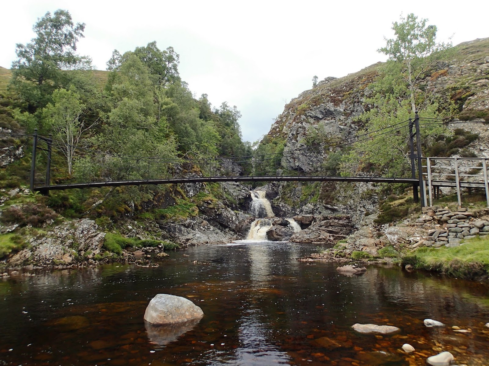
Eventually the burn is joined by the larger Tarf Water at Falls of Tarf, spanned by an elegant iron and timber bridge.  In dry conditions in one of the driest summers for years this is a quiet, pleasant spot; in spate these falls are an impressive sight.


The bridge is known as the "Bedford Memorial Bridge" and commemorates a young man drowned trying to cross the Tarf here in August 1879.  This is a slightly unusual meeting of waters; the Garbh Allt Bhuidhe is joined from the west by the Tarf Water and from the east by the Allt a'Ghlinne Mhoir (stream of the big glen), but from this point the combined waters enter Glen Tilt and are known as the River Tilt.

My route now left the main Braemar to Blair Atholl path and headed up the north bank of the Tarf Water.  There's a path shown on the OS 1:50,000 map, but it's a figment of the cartographical imagination.  The going was terrifically hard on rough and boggy ground, and I wouldn't wish to walk this section again any time soon.


Eventually I arrived at a much flatter area with better walking ground, near the pony stable below Dun Mor.  THe track coming in around the hill can be accessed from Glen Tilt some 3 kilometres down Glen Tilt from the Bedford bridge and if coming this way again I'd use this longer option.

I now had to decide which side of the Tarf Water to use in order to reach my destination for the night; settling for the south side which gave reasonable walking partly on a vehicle track.  After what seemed a long time, my planned accommodation came into view......


.....and after a long and exhausting day, it was a welcome sight - a building standing in splendid isolation in true "mamba" country.

Tuesday, 28 August 2018

Destination "mamba"


Late August in Scotland.  The hills are covered with the purple shades of heather, the sun shines on long days and all things seem possible.  Or......the midges are at their worst, the weather is muggy and oppressive and a heavy green and grey cloak covers the hills.  Towards the end of the month it seemed that there would be a bit of all of these things.  I'd initially planned a sea kayak trip but realised that forecast light winds and overcast conditions along the coasts would mean midge purgatory.

So, I looked for a backpacking trip which would give the opportunity of at least one night in a bothy, giving respite from the biting hordes.  The journey I settled on would take me into some of the most remote country Scotland has to offer - I'd need to be completely self sufficient in shelter and food so that if I didn't make the planned route I could still camp and be relatively comfortable.


Linn of Dee is the starting point for many long walks; to the north you can head off on some of the best known treks in the country; through the Cairngorms from Deeside to Speyside via the Lairig Ghru or the Lairig an Laoigh; or onto the great plateaux of the eastern Cairngorms and over to Donside perhaps.

Heading west, the choice is hardly less enticing - the routes shown on the Scottish Rights of Way Society sign indicate an alternative start to reach the Lairig Ghru and two great through-routes towards the west.

Anyone heading off on these journeys will enter true wild country, and though there are either tracks or defined paths the whole way, the challenges of distance and weather can test the strongest walkers.  Then there are the rivers - the routes to the west require crossings of water which can be running hard and fast; and there are no bridges over two of the most significant rivers.


My plan was to take the first part of the route from Linn of Dee to Blair Atholl, then head into the trackless country west of Glen Tilt to visit one of the most remote of bothies.  This view shows just the first few miles of my route, up the River Dee to the hills beyond.


The first significant river crossing at least has a bridge - White Bridge crosses the Dee and is a meeting point of tracks and paths (though it's not white!).


The view up the valley of the infant River Dee is one of glimpsed giants.  To the left, Beinn Bhrotain at 1108m/3635ft with the flank of the Devil's Point and Cairn Toul beyond -big hills for big days.


After such a dry summer I was confident of finding the water in the next river, the Geldie Burn, low - but I can't ever recall seeing it so low.  The Geldie is termed a "burn" (stream), but make no mistake, this is usually a river and it runs hard and deep in wet weather or during snowmelt; it's often impossible to cross safely and there are no bridges over it.  I've several times arrived here and found it birling along with an ominous rumbling sound of boulders being rolled along its bed - a crossing to treat with caution in normal conditions.

From here on I was entering "mamba" country.  Not referring to venomous snakes, thank goodness, the word is an acronym possibly coined by servicemen sent from southern England to serve in the Highlands and Islands during the Second World War.  "Mamba" stands for Miles and Miles of B*gger All !


Beyond the Geldie a substantial ruin stands in a patch of green sward, a bright spot among the heather.  This is (or was) Bynack Lodge, a ruined 19th century shooting lodge from the days of the great estates.  Perhaps it's the green setting or the trees surrounding the ruin, mainly pines and sycamores, which make this such a pleasant spot; I've always found this ruin a place of peace and have camped here several times.


The ruin has been stabilised by Mar Lodge estate and you can see some of the brickwork used to support the mortared rubble original wall.  There are actually a few ruins here, one building was a game larder with a subterranean meat store, there was a separate building which may have accommodated the staff, traces of kennels, a stable and even a walled garden.

One slightly surreal but enjoyable experience I had here was watching the balcony scene from Shakespeare's "Romeo and Juliet" being performed using the window sill in the left of this image as the balcony - and that can't have happened too many times!


After a final glance through the arched wall aperture back down the Bynack Burn towards Geldie I hoisted my rucksack and headed onwards; there was still a long way to go today, much of it "mamba".

Friday, 28 August 2015

Rain, clearing later...

About 2am I was woken by the wind which was by then gusting strongly. I got out of the tent to check the guy lines, noticing that the cloudbase was moving past rapidly just above the level of my camp. I hadn't long been back in the sleeping bag and was dozing off when sleep was again interrupted by the sudden arrival of rain. No gentle summer shower this; it sounded as if I'd camped in a car wash! For the next several hours I listened intently as huge gusts of wind approached with a rising whoosh, intensifiying the rain battering the tent. The gusts slammed into the tent, causing it to shake violently and although it spoiled my sleep I was comfortable and confident that my tent (a Terra Nova Voyager) would ride out the weather as it has done many times before.

The gusts and rain eased towards dawn and although the wind stayed strong it was a steadier thing. I slept for an hour or two and woke to the familiar sound of Ptarmigan calling from the rocks above my camp.


The view outside was initially very misty, clearing slowly to reveal a grey and breezy morning.  I was in no hurry and treated myself to a cup of tea in bed before emerging.......


.....to a rapidly improving scene.  The cloud was tearing away on the strong south easterly wind and a first blink of brightness appeared.


Within an hour, the change was complete and the morning was bright and sharp if still notably windy.  I took down the tent and moved above the loch to wait near the path where I knew that the Duke of Edinburgh's team would pass by.


I met with the participants, who'd had almost no wind at their camp in the shelter of the Loch Avon basin, though they could hear it roaring around the crags above.  We discussed whether their proposed high level route was achievable and they continued on their four-day journey; which for most would be a completely new experience in an environment they'd never before encountered.  It's one of the great strengths of the Award that it introduces young folk to the possibilities within themselves in this kind of setting.

As they headed towards the skyline in this image, my return route took a path left, following the outflow of the smaller lochan......


...down past the Hutchie, which had folk in residence....


...and down the long walk-out through the glorious pinewoods of Glen Derry.  At these lower levels the wind was reduced to a gentle and pleasant breeze - just enough to keep me cool in the strong sunshine and to ward off the midges.  By mid afternoon I was back at a busy car park, chatting with some folk who'd intended to camp out the previous night, but had elected to stay at the Youth Hostel in Braemar because of the forecast rain through the night.  They didn't know what they'd missed! 

Wednesday, 26 August 2015

Small things on a long walk


The Cairngorms in the north east of Scotland offer some great long walking routes, whether one intends to do a through-route or to do an "out and back" walk.  An appointment with a Duke of Edinburgh's Award team undertaking a Gold venture gave me the opportunity to to a little of both.

More than most wild country areas in the UK, walking the hills of the Cairngorms requires the ethos of the "long walk-in" as most summits are many hours from the nearest road.  The sense of space here is one of the features which defines the region - big views and big skies.

I was bound for the head of Loch Avon (pronounced A'an and meaning bright one), considered by many to be the heart of the Cairngorms and one of the real jewels.  After meeting with the team I intended to camp in one of the high corries to preserve their (and my) sense of being alone in a wild and remote area.

My route went from Linn of Dee and up through Glens Lui and Derry.  The view ahead in Glen Lui is long; I'd bear right at the wood in the far distance, my destination several hours away.  The car park was very busy on an August weekend, but such is the nature of the area that after the first few kilometres I actually saw very few people.


Near the former hunting lodge at the confluence of the Derry Burn and the Lui Burn a temporary bridge has been erected to replace the one swept away in the huge floods of August 2014.  You can read about the extent of the damage caused and about the building of the temporary bridge at Neil Reid's excellent "Cairngorm Wanderer" blog here and here.  The raw power released in just this one flood event serves to show just how small we are in the landscape - and in my opinion that's a good thought to have.


Perhaps this directed my train of thought to things smaller than the human scale, but nevertheless adapted to their place in the environment with all its sudden shocks.  Spotted Orchids (Dactylorhiza fuchsii) were still in flower.....


..and were joined in the damper ground by the golden flower spikes of Bog Asphodel (Narthecium ossifragum), a characteristic plant of high and late summer in the Cairngorms.


At the highest extent of the treeline I came across this Emperor Moth (Satunia pavonia) caterpillar moving purposefully across the track.  A big caterpillar at around 60mm long, it would have started black and orange before changing to bright green with pink spots (often the spots are yellow).  The only member of the Genus Saturnia present in Scotland, the moths have some unusual habits.  Male and female are differently coloured, the males fly rapidly during the day and the females much more sluggishly during the night.

The eggs are laid on food plants (mostly heather) in May, the caterpillars are fully grown like this one by August and spin a fibrous cocoon in which they overwinter, surviving even the harsh extremes of weather in the Cairngorms.  The adults live only a few weeks and don't feed as moths, spending time finding a mate and restarting the cycle.


I was pleased to see that both the tiny bridge and the Rowan tree at the Coire Etchachan Burn were still intact; the Rowan is about the highest tree in the area and has become a bit of an old friend.  It's here that I left the main through-route of the Lairig An Laoigh (Calves Pass) and branched up into the higher hills.


The "Hutchie" is a welcome sight at any time, but I wasn't intending to stay at the bothy on this occasion.  I stopped by to see that everything was in order and made a mental note to remove a couple of empty gas canisters left on the window sill when I passed on my return leg.  I still had a bit of a climb with what now felt a heavy rucsac so after a short rest I set out again up the corrie.....


....to reach a campsite in the upper corrie surrounded by cliffs and high ground.  The forecast was for strong south-easterly winds overnight and into the following day so I chose a site for the tent which would give some shelter from this direction - or at least as much shelter as can be found in this wild place.  I brewed some tea and rested for a while, just enjoying being out here.

Later in the evening I made the walk and steep descent to the head of Loch Avon to meet with the team, who were camped in one of the most spectacular locations possible.  I arrived back at my camp at dusk and ate dinner, aware of the strengthening wind.  Sleep came quickly, but it wasn't to be a restful night.....

Monday, 10 November 2014

Equipment Review - Crux AK70 rucsack

The Crux AK70 is marketed as a large mountaineering rucsack suitable for climbs in the Greater Ranges. Crux’s sister company Lightwave market a range of rucsacks aimed at trekking and backpacking, but the simplicity and design features of the AK70 make this sac suitable for backpacking as much as alpine climbing.

 I’ve owned the AK70 for four years during which time it has been used for multiday backpacking trips in all seasons, weathers and over a range of terrain. I should state at this point that I purchased the rucsack at very slightly less than retail price through a climbing shop discount, and have no connection with Crux at all.


The first thing that is noticeable about the AK70 is its clean, uncluttered design, a big plus for me.  There are none of the bells and whistles, attachments or multiple access points prominent in some designs.  When filled with gear the sac has a clean profile and is almost a throwback in being a classic top-loading single compartment rucsack.

The fabric is a Kevlar/Cordura weave which is light but incredibly tough.  The AK70 has survived frequent brushes with Cairngorm granite and Hebridean gabbro with ease, in fact almost without a scratch.  The base is double layer and is looks as if it will survive just about anything.  Although I pack using multiple small drybags inside any rucsack, I haven’t had any problems with water ingress despite all-day use in some really foul weather.  The body of the sac is a single piece of fabric sewn to the moulded back panel so there are a minimum of seams.  Attachment points for the compression straps and ice axe loops are welded to the fabric and seem capable of resisting considerable stress.  Crux point out that the fabric used in their AK range is twice the weight of fabrics used in competing products and therefore much more robust and yet their rucsacs weigh less than rival products due to the minimalist design.  The AK70 weighs in at a pretty light 1630 grams and feels lighter than it appears.


The lid of the sack is “floating” and can be extended to accommodate extra bulky loads or even removed completely (though I can’t envisage me needing to do that).  There are external and internal lid pockets, the outer has a water resistant zip with a useful zip-pull, the external lid pocket is cavernous and fits map, hat, gloves, snacks etc with plenty of room to spare. There is a compression strap across the top of the sac which sits under the lid for securing bulky items such as a rope.

Down the sides of the rucsack are further compression straps in a zigzag configuration which work extremely well to reduce volume when the sac isn’t fully packed.  There are also stretch wand pockets at each side of the base and simple but strong tape gear loops.  The wand pockets could be used for storing snacks or small items but I’ve found them most useful for securing the sharp tips of walking poles whilst traversing steep or broken ground.


Crux take pride in having developed a carrying system which is simple to the point of being Spartan – and when purchasing the sac this was the one doubt in my mind; would it be comfortable when carrying a load? 
Although pared-down to basics, the design and functionality shine through; a great deal of thought has been put into the back and harness.  .  Inside the body of the sac are a 8mm T6 alloy tube frame and a 12mm titanium centre stay, both removable, with a combined weight of just 65 grams.

The back panel is a large moulded panel with the maker’s name recessed into it (the only logo on the sack apart from a small woven one on the lid).  The back panel comes in three sizes, Crux recommend Size 1 for women and smaller men, Size 2 for average sized men and Size 3 for taller men.  At 1.75 metres I fall into the average range but actually found the smaller Size 1 back a better fit.  The back panel sits fully against the back, giving a large contact area for stability and bringing the centre of gravity closer to the wearer.  This would suggest that the Crux would be sweatier to carry than other rucsacks – but since I run pretty hot and generate a lot of heat anyway I haven’t found it to be noticeably sweatier than other backpacking sacs.  The stability from carrying the load close is really quite noticeable; on rough ground or in high wind the sac feels nailed onto one’s back, there is none of the unsteady feeling of a rucsack pulling in its own direction or sliding about when moving across rough ground.  There’s another advantage to the minimalist back panel, it doesn’t absorb water like open-cell foam padding.  This absorption can add noticeable weight to more complex back systems in wet weather.

Intelligent and functional design is also to the fore in the hipbelt, made of 40mm webbing with low profile hip fins.  The arrangement for tightening the waist belt is absolutely ingenious, it also prevents any loose straps around the waistbelt area – vital in a sac designed for mountaineering.  The belt itself is a continuous piece of webbing which wraps around the back beneath the back panel so that strain is transferred to the frame. The fin pads sit comfortably on the hips and support the majority of the load in a comfortable way.
The top tension straps are also continuous retained loops which pull off the frame rater than a row of stitching.  They give good adjustment to either haul in or slacken off the top of the load to suit and again have no loose straps to lash the face.

In use I’ve found the Crux AK70 to be a well-designed, simple but very comfortable rucsack.  Although not primarily designed for backpacking it does the job superbly well.  The quality of material used and the functional design make it stand out, the simplicity and understated features just do the job and do it well.  In hot conditions the back may be a little more sweaty than some other sacs with chimneys, vents and the like, but the trade off in terms of stability and light weight are, to my mind, well worthwhile. I can carry a 20kg load in comfort for long days whether on estate track, hill path or on rough trackless ground.  It is pretty much waterproof and incredibly tough yet weighs a lot less than most backpacking sacs.  The 70 litre capacity is well enough for the great majority of trips, and all of the capacity is usable space.

Is there anything I’d change?  Well, yes, a couple of minor things.  There’s no exit point for a drinking tube on the sac, so the hose has to exit at the drawcord.  A small flap near the front of the sack would be useful to avoid an awkward routing of the hose.  Also (and this really is nit-picking) it would have been useful to have loops for attaching elastic shock-cord to stow crampons on the back of the sac.  It’s relatively easy to add these and I do tie in some shock-cord for this purpose in winter, but some loops would be useful.
The version of the AK70 I own is a second generation model, first introduced in 2007.  A third generation model is due in 2015 and seems likely to feature all-welded construction and new Kevlar fabric claimed to be even lighter and tougher than the present material.

The quality of material, construction and attention to detail on the AK70 don’t make it the least expensive rucsac around, but I feel that you do get what you pay for here. There are much lighter rucsacs around from the “ultralight” manufacturers which have become popular in recent years, but the Crux requires no compromises in packing to compensate for flimsy construction and looks as if it will outlast ultralight several times over.

 If you’re looking for a high-quality, lightweight backpacking rucsack with a minimum of frills which will stand up to hard use then the Crux AK70 is very well worth a look.