Monday 27 February 2017

A good grey morning on the Sound of Arisaig


 When we emerged from our tents early on the final morning of the trip the colour palette could hardly have been more different than the previous evening.  The riot of colour in the sunset and the  blazing light across  the sea had been replaced with monotone shades.  Despite the overcast sky it had remained dry and the temperature wasn't as cool as the previous morning - this had the welcome bonus of allowing us to take down the tents dry as there had been very little condensation.


 Despite the greyness there was an austere beauty in the sky; the cloud lowering out to the west was a sure sign of an approaching weather front - it was time for us to get underway and finish our journey before it arrived. 


The evening sunlight had picked out the ridges and summits of the Cuillin beautifully during the evening but that had changed, the silhouette rendered soft focus as the clouds brushed the top of the hills.


 We estimated that we had several hours before the front arrived and had no need to hurry as our finishing point would be less than an hour's paddle.  We scattered the few ashes which remained from our fire, checked the camp site and headed out from the beach......


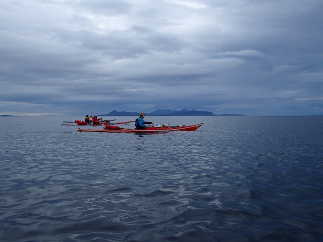
 ....onto the gunmetal grey of the Sound of Arisaig. It may have been monotone, but there was an austere beauty to the morning.  With a very light and variable breeze and almost no swell the sea lay like a sheet of steel out to Eigg, with the "other" Cuillin hills on the island of Rum beyond. At the left of this image is the low lying island of Muck which for sea kayakers appears to offer less interest than the other Small Isles......Douglas and I would beg to differ!

As we paddled across a grey sea under a grey sky it seemed that the only splash of colour was provided by our boats and paddle kit.  It's not always like this though and the sheer variety and subtlety of the changing light is a big part of what makes Scotland so alluring - the grey days can be as good as the sunny days and this was a good grey morning!


 Turning the point at Smirisary  brought the familiar view of Rois Bheinn, and also a bit of a headwind, the first time we'd had to paddle against the wind at all on this journey. It was short-lived though and soon we were heading close to the coast.........


......to end our journey on the sandy beach inside Samalaman Island.  The tide goes out a considerable distance at this spot and we had a carry of a couple of hundred metres with each of our boats to get them to the top of the beach.

While Mike and Lorna unloaded all four boats, Douglas and I ran the shuttle to retrieve the car from Glenfinnan.  As we were securing the last of the boats onto the cars the rain began - light at first but then very heavy for most of the journey home.


 Douglas Wilcox

 This was the last camping trip of 2016 as work commitments took over, but what a super journey it had been once again.  We've now enjoyed this 50 km journey from fresh water to the sea  between Glenfinnan and Glenuig in early Spring and in Autumn, it's a trip to savour.  We took two days and nights to do the journey this time, and if extending to Lochailort it's worth adding an additional night.

Sunday 26 February 2017

Just look around us.....


We landed on a white sand beach on the south side of Port Achad an Aonaich (probably port of the ridge field which describes it well).  This place has a number of names and in summer is popular for Outward Bound camping groups.  If the beach on the south side isn't to your taste, there's an equally beautiful white sand beach on the north side of the point!

We pulled our boats a little way above the high water mark and set up our tents - there's enough space to spread out here if required and the turf makes excellent ground on which to camp - except in wet conditions when the sand below the grass seems to stick to everything.


Having pitched our tents and carried sleeping bags and mattresses up from the boats we paused to take in the view - and what a view it is.  The Small Isles - Eigg, Rum and Muck (Canna isn't visible from here, being hidden behind Rum) lie to the west, while up to the north there was this glorious view of Skye beneath an arcing cloudscape.

The Cuillin ridge is prominent in the centre, lit by the late sunshine with a warm brown glow.  To the right, across Glen Sligachan are Bla Bheinn and a glimpse of Marsco in full sunshine.  To the left the west coast of Skye stretched away into the distance, rendered sharp in the cooling air.

Having made space in the boats, Douglas and I paddled back to the entrance of the North Channel and made a landing on the rocks to collect firewood.  We managed to collect a couple of bags and cut some sections of branch from a bleached dead tree washed up and wedged into the rocks.  This was the second visit I've made to this tree and what's left will require cutting with something bigger than our folding pruning saws!


The wind died completely and the sun began to set as Douglas and I made our way back. For a short while it seemed to us that the world held its breath - the only sounds were the occasional calls of shorebirds.  We slowed right down, it felt right to pause and watch rather than disturb the silence by paddling.


As the sun touched the horizon beyond Ardnamurchan Point a blaze of glorious golden light poured across the still surface of the sea.  Douglas had the vision to turn his camera away from the sunset and captured perfectly this transient and gorgeous light. Rays from the setting sun reached up and fired the base of the clouds.......


.....which began to glow in fiery shades.  We landed on the beach and joined Mike and Lorna who had climbed a little way up the point to get the full widescreen view from Ardnamurchan to Skye and beyond, all backed by the incendiary riot of sunset colour reflecting off the sea.  Lorna summed it up perfectly when she said "Just look around us......right now this is the best view in the world".

We cooked and ate dinner outside the tents, absorbing the view and certainly for my part thinking how incredibly fortunate I am to be able to enjoy experiences such as this.  After diner we gathered on the beach and lit a driftwood fire below the tideline....


...which burned bright as the embers of the sunset finally subsided some hour and a half after the sun dipped below the horizon.  The glow of the fire lit our conversation for several hours afterward as we reflected on the trip so far.  The morning would require just a short paddle, but the forecast was not good as the brief spell of settled October weather would be replaced by the strong wind and rain of an Atlantic low pressure system.

Friday 24 February 2017

Eagle and Eigg


 We entered the North Channel which sepearates Eilean Shona from Moidart at about an hour before HW, planned so that there would be plenty of water (which isn't always the case!) and so that we wouldn't be paddling against any appreciable tidal movement.  The view through the channel neatly frames one of the most distinctive silhouettes of the west coast.....


...An Sgurr, highest point of the island of Eigg, which has a presence out of all proportion to its modest 393 metre/1289 ft height and gives the impression of a great ship sailing the Sea of the Hebrides.


The North Channel is bounded on both sides by rugged, steep slopes which fall right to the water.  Above the woods at Bad an Dobhrain (Otter Bay), Lorna spotted movement high up on a crag - a great shape which unfurled itself and soared effortlessly along the ridgeline - a White Tailed Eagle (Haliaeetus albicilla)

A conservation success, the White Tailed Eagle has been reintroduced from 1975 - a programme that is continuing.  The species was hunted to extinction in the early 20th century and there are probably still less than fifty breeding pairs of these huge birds in Scotland - it's always a thrill to see one.  We watched the bird manoeuvring to keep us in sight,its  head swivelling as it wheeled to ride the updraught.  A difference in behaviour between the two eagle species found in Scotland is that Golden Eagles will usually fly away for some distance if they see humans, whereas the White Tailed Eagle usually flies just far enough away to feel comfortable and then will often land again.


We paddled out of the North Channel and onto the open sea of the Sound of Arisaig with a view ahead to the island of Rum beyond Eigg.  Right at the entrance to the channel I knew there to be a considerable amount of driftwood washed up among the rocks- we could use some for the fire we intended to light at our camp.  The tide was now full which would have made for a very awkward landing on the rocks so we paddled on, noting where we might be able to land once it had dropped a little.


Heading north up the coast we were bathed in warm early evening sunshine and just a breath of breeze moving the air - it was a perfect autumn evening and despite the fact we'd had a fairly long day our movement felt effortless.


Our intended camp site was visible from quite some distance, a flash of emerald green grass and dazzling white sand among the rich autumn brown of the heather and bracken slopes.  There can be few better places to have been on this lovely evening.....

Wednesday 22 February 2017

Layered light at Loch Moidart


We paddled away from the mouth of the River Shiel on salt water for the first time on this journey.  Ahead of us Castle Tioram was lit by the afternoon sun ; we paddle this area quite frequently and I've noticed that when the sun isn't shining - a rare occurence on the west coast of Scotland :o) - the castle seems to recede into the background and can be hard to make out when paddling from the mouth of Loch Moidart. No such difficulty today and we aimed straight towards the castle and its small island.


The castle takes its name from Eilean Tioram (dry island) and this probably refers to the fact that at low water the island is connected to the mainland by a sandy spit which disappears at high tide.  A stone built castle is recorded here from the 1200's but the present building probably dates from the 13th century.  For most of its history a Clanranald stronghold, Castle Tioram is currently the subject of a stalemate between its owner who wishes to convet it to a private dwelling and Historic Scotland (now Historic Environment Scotland) who wish to consolidate the ruin and preserve it for the nation.  It's a difficult situation but there may be a way forward following recent negotiations - lets hope so because while the dispute rumbles on the fabric of the building crumbles.


 At the seaward side of the island is a beautiful little beach of shell sand and coral - complete with a rocky arm to form a sun trap.  Second luncheon was proposed and carried by a unanimous majority...  We took off layers of clothing as we sat eating lunch in the warm sunshine, Douglas took this to the logical conclusion and enjoyed a swim in water which he reported as warm (for a given value of warmth - and as compared to the chill of deep Loch Shiel!).  We three joined Douglas in taking a restorative dram of Jura 10 year old, after all, we were in no hurry as we were waiting for the tide to rise sufficiently to allow up to paddle through the north channel of Loch Moidart.


 The southeastern tip of Eilean Shona still bears scars from the severe winter storms of a couple of years ago which blew down trees, stripped branches and even lifted the thin layer of turf on the shoreline rocks.


 We'd left some of our own layers off in the warm afternoon sunshine and as we passed behind Riska Island and into the wide inner part of Loch Moidart, layers of low inland cloud building in the warmth began to produce an unusual effect......


 .....of alternating light and shade - at first confined to a narrow area.....


 ...but widening gradually to encompass a sweep of tree, water and hill in layers of light.


Tranistory and unusual, my photographs don't really do justice to the alternating effect and it lasted just a few minutes before the clouds moved enough to change the scene.


We paddled on towards what appears to be a closed corner of Loch Moidart, but where we knew the North Channel lay between sun and shadow.

Tuesday 21 February 2017

Going with the flow


We left Eilean Fhianain with a brisk easterly breeze at our backs - one of the reasons we'd chosen this particular trip was the predominantly easterly wind which was forecast - it would either be at our backs or we'd be sheltered on the west coast.

A last look back towards the mountains of Loch Shiel.......


...and then steadily onwards along the stretch of water which isn't quite Loch Shiel and isn't yet ruly the River Shiel.  Shallow water lined with salt marsh, this is a great place for waterfowl and waders to feed and to rest.

Talking of feeding and resting.....


....we landed near the jetty at Acharacle in order to check out the options for first luncheon.  Acharacle (Torquil's ford) is named for a Norse leader who was killed here along with all his men in a battle with Somerled, Lord of the Isles in 1120.  Torquil's men found the water too deep to cross and they were killed making a last stand near this spot.


We walked up the small road which leads from the wooden jetty to the village shops......where we had a choice of eating in at the Acharacle Tearoom or purchasing lunch to eat outside the Bakery. 


As we were in our paddling clothes - and it was anyway such a nice morning - we chose to eat outside the Bakery.  The coffee and Foccaccia bread are particularly recommended by your reviewers!

Acharacle is a handy stop in this area, it has a couple of options for food, a shop, and public toilets with a tap outside for topping up water.


Fuelled up and rested, we got back on the water, our boats being drawn along by the now noticeable current towards the fine triple arched road bridge over the River Shiel, built in 1935.  The footings of the bridge supports were clear of the water which certainly hadn't been the case on our winter trip, and the river flow was markedly less too.


Shortly after the road bridge the river narrows quickly and swings into a rocky gorge.  At the end, the old bridge crosses the river at the point of a ninety degree left bend.  Built by Thomas Telford in 1804, it was too narrow to carry motor vehicles and was replaced as a road bridge by the 1935 version.  You can walk from the road to this bridge and cross it, but the south side is private property.

Beneath the bridge is a small rapid where the water runs over a rocky shelf - with more water in the river it can prove exciting, but as the level was quite low it was little more than a quickening of the flow.


The rapid marks the end of the narrow section, the water slows and the river becomes wide and shallow.  A wooded hill makes a lovely backdrop to a very relaxing section of the trip where we were able to just go with the flow in the literal sense.

If making this journey when the water level is relatively high, it's good to know that there are a couple of potential egress points to allow a portage around the tidal fall where the river empties into the sea.  The first is at a gauging station marked by wires crossing above the water - we used this during our winter trip when the river was quite full.

The second point is a small patch of flat grass jutting out into the river, which Douglas, Lorna and I used to land and carry our boats up to the track alongside the water; Mike found a spot further down again, but after that there's just one option immediately above the falls - miss it and you're committed....


We put the boats on the trolleys we carried specifically for this section and portaged along the estate track through woods of beech and pine - despite pulling the boats this was a very pleasant section.  Once again the trolleys (three KCS Expedition models and one Lomo model) proved their worth and performed faultlessly.


A short detour to view the tidal fall is well worth the effort - if only to assess whether you feel it could have been paddled.  The drop from river to sea is the result of isostatic rebound, the continued rising of the land in this part of Scotland following the release of ice from the last ice age.  The fall itself is affected by two things; the amount of water in the river and the height of tide - in simple terms, when the tide is low the river has further to drop.  On neither occasion we've been here have we felt the slightest inclination to run the fall in fully laden sea kayaks......

This is the fall in comparatively low river levels but also a low tide.......


.....and this is the fall on our winter trip with more water in the river but a higher tide. 


Immediately beyond the point where the river ends, we arrived at the shore of Loch Moidart.  We carried our boats down over a patch of saltmarsh to place them, for the first time on this journey, into salt water.

Sunday 19 February 2017

Stones, bones and clear tones on the island of Finan the Leper


We were up and about early at our camp on the shore of Loch Shiel, the cool air of post dawn a reminder that the season was turning.  It was cool rather than cold though and there was no sense of needing to get moving to warm up.


 The morning sun was beginning to rise above the hills on the east shore of the loch as we finished packing, though our beach remained in deep shade. 


 By the time we were about ready the morning clouds were beginning to burn off....


 ....and it looked set to be a fine autumn day. 


 After a short distance we came to the narrow twist which marks the end of Loch Shiel proper, and a distinct change in scenery.  We'd been journeying through rugged and wild mountain scenery, ahead lay lower ground with wider views towards the sea.  The narrow bend as the loch finds its way from the mountains is almost blocked by a small island - the terminal moraine of the glacier which ground out Loch Shiel.

Eilean Fhianain (Finan's Island) may be small and unspectacular from a distance, but it has a wealth of interest and history and there was no way we were going to pass by without exploring a little of it.  Finan was an early Celtic saint who is believed to have lived from around 520 to 600AD.  Details of his life are uncertain but he seems to have followed Columba from Ireland and became Abbot of a small monastery on the island now named after him.  He is believed to have evangelised much of Argyllshire, but considering that his name crops up all over Scotland - as well as the obvious Glenfinnan and Kilfinnan, there is a St Finzean's Fair in Perth and a Finzean as far away as Aberdeenshire, he must have travelled extensively

Known as "Finan the Leper" from the disease which afflicted him, he seems to have favoured small islands on lochs; he is also recorded as the founder of at Inisfallen on Lough Leane in Ireland's County Kerry.  Finan died, it is thought, at Clonmore in his native Ireland.


 We'd visited Eilean Fhianain on our winter trip in 2014 and found it to be a gem of a place.  That visit had been made in brilliant sunshine, this one in quite different lighting, but the place still had an air of peace.  We passed the gravestones which appear very old but in fact are probably 18th century......


 ....and stopped to admire the cross commemorating Rev Charles McDonald, priest of the diocese of Argyll and the Isles.  I hadn't noticed on our previous visit, but many of the trees on the island are Rowans, the tree of protection. 


 The sides of the column bear fine sculptures in the distinctive Celtic style, and there's a clear difference between the weathering on the western side of the cross which faces the prevailing weather.....


 ....and those on the more sheltered eastern face, these tail-chasing beasts and intertwined snakes are still in sharp relief. 

Note: Our friend Leif  has pointed out that the bodies of the snakes seem to form the letters "V" and "M" - it would be fascinating to know whether this was deliberate or a coincidence of pattern; and if deliberate what the letters represent.


 The ruined chapel near to the highest point of the island has an intact altar slab, behind which a very old stone cross occupies the niche, and a wooden boat-shaped object upon which small offerings of coins had been left.  A rummage in our pockets produced some coins to add to the amount.

But it is the bell which captures the imagination -  seamlessly cast in bronze, it has lain here for almost eleven centuries.  It takes a moment for that to sink in....produced in the 10th century, it has survived all the long tumult of history intact.  Nowadays secured by a small chain, one can clearly see the marks on the altar slab where the bell has rested.

Not only is the bell still intact, it remains fully functional -  Douglas' video of it being rung catches the clear tone.


 If St Finan's bell is the jewel of the island, nature has provided a few of her own.  It's amazing how often the walls of ruined churches are studded with the blue flowers of Ivy-leaved Toadflax (Cymbalaria muralis), here growing intertwined with a fern.

We continued over the island from the ruined chapel and Lorna found a remarkable grave-slab half concealed below the grass.   We cleared the grass a little to find......


 ...a very definite image of mortality carved in stone.  It seems that our predecessors were altogether less reticent about portraying death in this way - it's a fascinating grave if a little startling to the modern eye.


 As we made our way back to the boats we passed a much more recent grave, well tended and laid with flowers, backed with a bush fired with intense autumn colour.

This small island had proved well worth a second exploration - and on future visits we'll stop here again without doubt.


We got back on the water as a breeze sprang up, clearing the cloud quickly.  The mountains lay behind us, and ahead lay a river and the sea.....