Friday 31 August 2018

A meeting of waters


Climbing up beyond Bynack Lodge, there's a last long view over towards the main Cairngorm group; Beinn Bhrotain in the middle distance, Cairn a Mhaim and Ben Macdui beyond.  The camera hasn't caught it, but I could clearly make out the cliffs of Coire Sputan Dearg (corrie of the red spouts) to the right of the summit cone of Ben Macdui.


The path towards Glen Tilt then enters a green valley below the hidden Loch Tilt known as Bealaidh Sidhean (fairy pass) , which probably recalls the grim Celtic "Sithean" (pronounced Shee-an) rather than the type of fairies with twinkly green outfits.  I've walked this stretch several times but hadn't previously noticed the small milestone in the mossy ground.  Just about 15cm tall, I think the 15 refers to the miles from Blair Atholl to this point.  It's also just about at the county boundary where one steps from Aberdeenshire into Perthshire.


Having crested the rise and gone "over the hill", the way ahead follows the clear stream of the Allt Garbh Bhuidhe (rough yellow stream) as it enters a narrow valley - ahead there's a glimpse of one of Perthshire's best hills, the multi-summited Beinn a'Ghlo which has three Munros.  I tried to recall the last time I'd climbed that fine ridge and decided it's too long ago....another one to go back to soon!


The Garbh Allt Bhuidhe runs through quite a remarkable gorge which looks like a glacial breach.  The path traverses close to the burn, sometimes at a level with the water and sometimes quite high above across steep slopes.


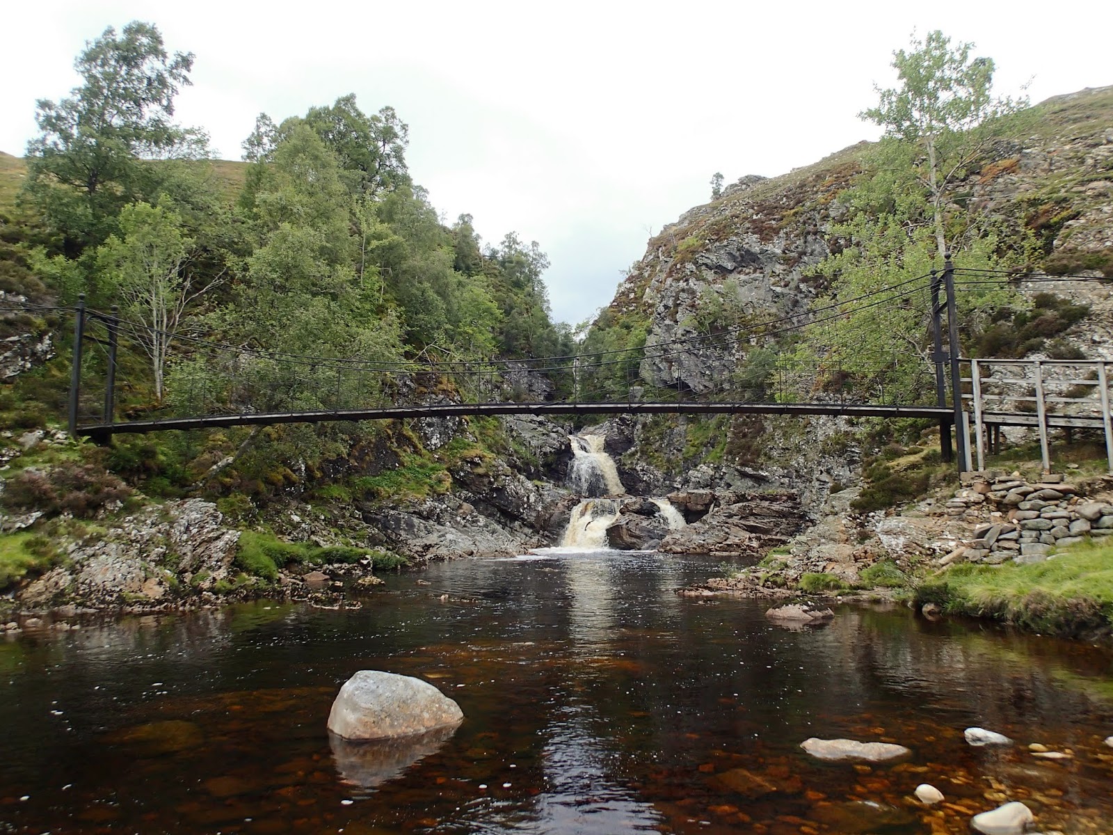
Eventually the burn is joined by the larger Tarf Water at Falls of Tarf, spanned by an elegant iron and timber bridge.  In dry conditions in one of the driest summers for years this is a quiet, pleasant spot; in spate these falls are an impressive sight.


The bridge is known as the "Bedford Memorial Bridge" and commemorates a young man drowned trying to cross the Tarf here in August 1879.  This is a slightly unusual meeting of waters; the Garbh Allt Bhuidhe is joined from the west by the Tarf Water and from the east by the Allt a'Ghlinne Mhoir (stream of the big glen), but from this point the combined waters enter Glen Tilt and are known as the River Tilt.

My route now left the main Braemar to Blair Atholl path and headed up the north bank of the Tarf Water.  There's a path shown on the OS 1:50,000 map, but it's a figment of the cartographical imagination.  The going was terrifically hard on rough and boggy ground, and I wouldn't wish to walk this section again any time soon.


Eventually I arrived at a much flatter area with better walking ground, near the pony stable below Dun Mor.  THe track coming in around the hill can be accessed from Glen Tilt some 3 kilometres down Glen Tilt from the Bedford bridge and if coming this way again I'd use this longer option.

I now had to decide which side of the Tarf Water to use in order to reach my destination for the night; settling for the south side which gave reasonable walking partly on a vehicle track.  After what seemed a long time, my planned accommodation came into view......


.....and after a long and exhausting day, it was a welcome sight - a building standing in splendid isolation in true "mamba" country.

Tuesday 28 August 2018

Destination "mamba"


Late August in Scotland.  The hills are covered with the purple shades of heather, the sun shines on long days and all things seem possible.  Or......the midges are at their worst, the weather is muggy and oppressive and a heavy green and grey cloak covers the hills.  Towards the end of the month it seemed that there would be a bit of all of these things.  I'd initially planned a sea kayak trip but realised that forecast light winds and overcast conditions along the coasts would mean midge purgatory.

So, I looked for a backpacking trip which would give the opportunity of at least one night in a bothy, giving respite from the biting hordes.  The journey I settled on would take me into some of the most remote country Scotland has to offer - I'd need to be completely self sufficient in shelter and food so that if I didn't make the planned route I could still camp and be relatively comfortable.


Linn of Dee is the starting point for many long walks; to the north you can head off on some of the best known treks in the country; through the Cairngorms from Deeside to Speyside via the Lairig Ghru or the Lairig an Laoigh; or onto the great plateaux of the eastern Cairngorms and over to Donside perhaps.

Heading west, the choice is hardly less enticing - the routes shown on the Scottish Rights of Way Society sign indicate an alternative start to reach the Lairig Ghru and two great through-routes towards the west.

Anyone heading off on these journeys will enter true wild country, and though there are either tracks or defined paths the whole way, the challenges of distance and weather can test the strongest walkers.  Then there are the rivers - the routes to the west require crossings of water which can be running hard and fast; and there are no bridges over two of the most significant rivers.


My plan was to take the first part of the route from Linn of Dee to Blair Atholl, then head into the trackless country west of Glen Tilt to visit one of the most remote of bothies.  This view shows just the first few miles of my route, up the River Dee to the hills beyond.


The first significant river crossing at least has a bridge - White Bridge crosses the Dee and is a meeting point of tracks and paths (though it's not white!).


The view up the valley of the infant River Dee is one of glimpsed giants.  To the left, Beinn Bhrotain at 1108m/3635ft with the flank of the Devil's Point and Cairn Toul beyond -big hills for big days.


After such a dry summer I was confident of finding the water in the next river, the Geldie Burn, low - but I can't ever recall seeing it so low.  The Geldie is termed a "burn" (stream), but make no mistake, this is usually a river and it runs hard and deep in wet weather or during snowmelt; it's often impossible to cross safely and there are no bridges over it.  I've several times arrived here and found it birling along with an ominous rumbling sound of boulders being rolled along its bed - a crossing to treat with caution in normal conditions.

From here on I was entering "mamba" country.  Not referring to venomous snakes, thank goodness, the word is an acronym possibly coined by servicemen sent from southern England to serve in the Highlands and Islands during the Second World War.  "Mamba" stands for Miles and Miles of B*gger All !


Beyond the Geldie a substantial ruin stands in a patch of green sward, a bright spot among the heather.  This is (or was) Bynack Lodge, a ruined 19th century shooting lodge from the days of the great estates.  Perhaps it's the green setting or the trees surrounding the ruin, mainly pines and sycamores, which make this such a pleasant spot; I've always found this ruin a place of peace and have camped here several times.


The ruin has been stabilised by Mar Lodge estate and you can see some of the brickwork used to support the mortared rubble original wall.  There are actually a few ruins here, one building was a game larder with a subterranean meat store, there was a separate building which may have accommodated the staff, traces of kennels, a stable and even a walled garden.

One slightly surreal but enjoyable experience I had here was watching the balcony scene from Shakespeare's "Romeo and Juliet" being performed using the window sill in the left of this image as the balcony - and that can't have happened too many times!


After a final glance through the arched wall aperture back down the Bynack Burn towards Geldie I hoisted my rucksack and headed onwards; there was still a long way to go today, much of it "mamba".

Sunday 19 August 2018

Eggs for breakfast on the return from Eigg


Mike and I woke after a muggy and warm night to a soft focus morning at our camp on the Sound of Arisaig.  The midges were also up and about so we didn't hang around sorting out our gear, having a cup of tea and repacking the boats.


The tide was quite high meaning that there wasn't far to move our boats for launching.  The previous night's high water mark was obvious on the stones; we'd parked the boats on the flat patch where our blue bags are in this image.  If there had been any swell at all they'd have gone quite a lot higher!  The steep slope of the beach is clear in this image; if the weather is from the south or south south west this place can make a tricky launching and landing place. 


We headed out onto the Sound of Arisaig and into a gorgeous summer morning.  The sun was burning away the early mist and creating some lovely lighting effects.  Being out early like this I often feel as if I'm gaining something, and it's such a good time for scenic effect and for wildlife encounters.


There wasn't a breath of wind and the only sound was the rhythmic dip of our paddles as we made our way steadily across the Sound.  The view to the east was one of silhouettes........


...and to the west, Mike's boat was lit against the palest of blue in the morning sky; the horizon just becoming visible as the last of the mist burned away.


Our crossing to Glenuig was a little over six kilometres and took just over an hour.  Our plan for an early start was rewarded by an arrival at Glenuig just a couple of minutes before high water on a Spring tide. We landed right outside the Glenuig Inn; from where it's just fifty paces to the door......


...and the second element of our plan - breakfast!  We tucked in to cereal and fruit juice, and ordered coffee and - of course - scrambled eggs on our return from Eigg.

This was a very fine end to our trip, during which we'd kayaked from Glenuig out to Eigg, paddled around the island and climbed to the highest point at An Sgurr before paddling back via the Sound of Arisaig.  We took three days and a few hours to do the 92 kilometre journey (including the climb of An Sgurr), a leisurely pace which very much suited the nature of the trip.

Monday 13 August 2018

Nesting and perching above the Sound of Arisaig


On our way along the shore of the Sound of Arisaig towards Loch nan Uamh Mike and I passed a few camping spots which we've used on previous trips.  The overcast weather, warm air and lack of a breeze meant that the midges would be particularly troublesome, so we opted for this pebble beach.  There's some flat ground above the beach for camping, and we knew we could get up onto a rocky spur to get away from the worst of the little devils.

What this image doesn't show very well is that the beach is quite steep; landing or launching here when the weather is from the south can be tricky.  We carried the boats up to a flatter area just above the high water mark, and were able to watch the tide come up then recede during the evening.


I've always loved the pebbles on this particular beach; what appear to be uniform pale grey pebbles at first glance are transformed into rich shades of brown, dark and light grey, bottle green and deep red when they are washed by the water.


Waterworn and tumbled, I wondered what the story of each individual pebble might be - fascinating to imagine the processes that have led to their deposition here.  As many are Lewisian Gneiss, one of the oldest rocks on the planet, that story might be a long tale.

We pitched our tents and carried stoves and food up onto the rocky spur.  On the way up a Meadow Pipit (Anthus pratensis) shot out of a bank near the path. 


On the way back to collect some more stuff, I looked carefully at the place it had emerged, and saw the glitter of a tiny eye looking back at me.  Once again the bird shot out, and a closer look revealed a beautifully concealed nest containing a clutch of young chicks.  We hurried on, and very soon the bird returned to her nest.  When moving to and from the beach we tried to avoid this spot so as not to cause disturbance, but each time were seen carefully away by the little bird.


From our own perch, we looked out across the Sound of Arisaig to the Glenuig shore and beyond to Ardnamurchan which was just visible in the mist.  We had originally intended to spend most of the following day paddling these waters which we know pretty well, but a look at the tide times and the weather forecast caused us to change our plan slightly.  Intending an early start, we turned in soon after supper - I ducked into the tent having raced around to lose a cloud of midges intent on their own supper.

Thursday 9 August 2018

A crossing from Eigg and the colours of summer

We had a leisurely start in our camp at Kildonnan, there was a strong north easterly breeze blowing as we ate our breakfast but the forecast was for the wind to drop as the morning went on.  We had a back-up plan which involved taking the lunchtime ferry to Mallaig if the wind remained strong, though we were very much hoping to complete the journey back to the mainland under our own steam.


The forecast was accurate and the wind had dropped markedly by mid morning.  We got underway and headed out from the shore of Eigg, knowing that it's an island we'll return to.


The conditions were just about perfect for sea kayak sailing - we hoisted our Flat Earth sails and felt the immediate increase in speed as the sails filled and began to pull strongly.  The was a short chop in some areas as the tide swirled up the Sound of Arisaig which only added to the fun........


....and we weren't the only ones enjoying the conditions.  This fine traditionally built yacht was absolutely spanking along and we got a cheery wave from her skipper.

The wind dropped to a very light breeze as we neared the Arisaig shore and we once again felt the full heat of the midday sun.  We were aiming for the beach at Port nam Murrach which had been the jumping-off point for our outward crossing two days previously.  The enclosed channel is quite difficult to locate from seaward, but a GPS waypoint kept us straight.....


....and we were soon cruising in to the idyllic little beach with jade green water beneath our kayaks.


The clarity of the water in this bay always delights, the colours change with the state of the tide and the reflection of the sky. Eigg is prominent in the seaward view, some 14 kilometres across the Sound of Arisaig.  With the assistance of our sails the crossing had taken a little over two hours without undue effort.

We were pleased to have been able to paddle out to Eigg, circumnavigate the island, climb to its highest point and then to paddle back to the mainland. Our journey wasn't over, but we now had a the remainder of the day to spend cruising the Arisaig coast, and we planned to spend an further night on the journey too.


In contrast to the morning we set out to Eigg we had the beach at Port nam Murrach to ourselves.  We enjoyed a leisurely luncheon stretched out on the cropped turf above the sand, absorbing the atmosphere of the place.  The machair  and rock outcrops were studded with the bright colours of early summer flowers, so we took some time to just stroll around and enjoy them.


Thrift (Armeria maritima) was at its very best, the seemingly delicate flowers nearly all open in the bright sunshine.  This is one of my favourite wildflowers, it's equally at home on salt-lashed shorelines and right to the summits of our mountains - a truly tough little plant.


Three different plants in this image,  the tiny purple flowers are Wild Thyme (Thymus polytrichus) - the leaves of which can be used to add a lovely flavour to camp food.  The yellow flowers are Birdsfoot Trefoil (Lotus corniculatus) which hadn't fully formed the red buds which give it the alternative name "Bacon and Egg plant".  Between the two, a White Clover (Trifolium repens), a useful fixer of nitrogen in soils.  All these plants are favoured by bees and hoverflies and we saw some of the mining bees for which this site is known feeding on the flowers.


This tiny succulent plant was growing in amongst the boulders - I think it might be English Stonecrop (Sedum anglicum) - but I'm not at all certain. 


I'd been mildly surprised that there was nobody else at this popular spot, and as we put our lunch things back in the boats, a guided party of kayakers arrived.  They'd paddled out from Arisaig and had been enjoying seeing the seals among the skerries in Loch na Ceall before heading down to Port nam Murrach for lunch.  What better introduction to sea kayaking could there possibly be to padle in a stunning location with great wildlife, calm seas and dazzling beaches?!


Mike had joined me in searching the shore ...... and we were delighted to find a few "Groatie Buckies".  There's a risk in finding one though; as those who paddle with me will know, hours can pass while I indulge in this addictive pastime! Having found a couple each to add to our jars of these lovely little shells, Mike managed to persuade me that it was time to go.....


In the space of about 30 minutes while we'd been intently looking at the sand in search of shells there had been quite a change in the weather.  A cloud sheet had formed, the breeze had disappeared completely and the air felt heavy and warm - it seemed that there might be some thundery weather.  We discussed possible spots to camp for the evening and decided to dawdle along the coast of the Sound of Arisaig towards Loch nan Uamh to assess a couple of places we've used previously.

Tuesday 7 August 2018

Eigg time at a Kildonnan camp


This image, taken on our ascent of An Sgurr, shows most of the way down - across the moor then down through farmland and woods to Galmisdale which is to the right of the pier.  We went down quickly even though we were sweating profusely in the afternoon heat. We passed a couple of other parties on the way down, who must have wondered what all the rush was about......


.....until they arrived back at the Galmisdale Cafe and Bar and found us resting in the shade with containers of chilled sports recovery drink!  We felt that the level of dehydration merited two such containers apiece, after which we headed over to our boats, unpacked and pitched our tents.

Camp established, we wandered back to Galmisdale.  As well as a cafe and bar, there's a shop, a craft shop and information hub plus toilet and shower facilities and an outside tap to fill water containers. There's free wi-fi in the immediate vicinity of the building which is very useful for obtaining up to date weather forecasts as mobile phone coverage is somewhat patchy here. The toilets and showers are accessible 24 hours, there's an honesty box with a suggested donation for use of the showers which we were very happy to pay.

We collected a couple more sports recovery containers prior to the shop closing and walked back around to our camp.


The old part of the harbour has some craft moored up which have definitely seen better days.  Remarkably, the old passenger launch still floats, rising on each tide before settling back at low water.  The lines of this launch looked familiar, it was only after returning home and reviewing my images that I realised she is (or was) an Admiralty Harbour Launch Diesel (HLD), similar to this one.  A design which remained unchanged for decades, the HLD's were timber built, 52 foot launches powered by a Foden FD diesel engine and were used for transporting personnel around dockyard ports - I must have travelled on several of them over a period of time.


Mike and I spent a most pleasant evening at our camp.  Dinner was cooked and eaten, accompanied with the previously obtained sports recovery drink with a view across the Sound of Arisaig to the hills and sea lochs from Mallaig to Ardnamurchan.  A north easterly breeze picked up again during the early evening, keeping the midges away nicely.  We voted to postpone a decision on the following day's activity until the morning weather forecast and simply took our ease, enjoying the situation and the view.....we were operating on "Eigg time"!

Sunday 5 August 2018

Fried on Eigg

After enjoying lunch and checking out the facilities at Galmisdale Mike and I returned to our boats and paddled a couple of hundred metres round to the bay which is recommended for yachts to anchor and for informal camping


I knew from a previous visit that the ground behind the bay is also used for grazing sheep and cattle - and sure enough some of the cattle were cooling themselves in the water when we arrived on the beach.While we felt that they'd have seen it all before and would be unlikely to bother us, we felt t wise to leave everything in our boats rather than pitching the tents straight away in case one of the younger beasts got curious....

Having used a trolley to half pull and half carry each boat up the soft sand, we got changed into shorts and light shirts for a bit of a walk.  We each had an ultralight rucsac in our boats and packed these with water, some snacks, a long sleeved top and sun cream....good to go.


Heading up the track back towards Galmisdale, we found where the sheep normally on the machair had gone......everything on Eigg is dual purpose where possible!  These ewes had the right idea, at just gone 1pm the heat was pretty full-on, and they still had thick fleeces.


At Galmisdale there's a sign board detailing waymarked walks, with each walk having a colour code.  The coloured waymarks are a bit sketchy to find - if, like us, you want the quickest route to climb An Sgurr, take a track up through some pretty woodland, then follow a rough track across open pasture to reach a gate near this house.  The route then goes left beyond the house and then immediately right - not that obvious but once on the hill path, very straightforward.

This must be one of the most photographed views of An Sgurr, it has a nice composition with the house giving some foreground - and is also a good place to pause on the first of the steep slopes!


There really isn't much doubt which way the wind blows here.  This tree, unexpectedly it's a Beech, was older than its size suggests, cropped and sculpted by the wind.


The climb towards An Sgurr is steady and uncomplicated, just a couple of rocky steps on the crossing of a moor which laps the base of the prow - which gets steadily more impressive as you approach.

The Sgurr is the southern termination of a pitchstone ridge which runs along the spine of Eigg.  Formed during the birth of a huge volcano complex which included creation of the island of Rum, it is effectively a mirror image of the landscape of 58 million years ago.

Pitchstone is formed from viscous lava flows and is tougher than the usual basaltic lavas.  The story of the Sgurr ridge is this:

As the Rum volcano complex erupted, a layered basalt lava flow landscape emerged, covering the ground to the level of the present day ridge.  Over time (about 6 million years), a valley was eroded out of the basalt lavas, and when the pitchstone lava was erupted it filled this valley to the brim. Because pitchstone is so much harder than basalt it resisted erosion as the basalt around it was worn away, so what you see today is an inverted valley, like a jelly-mould image.  There's a good explanation of the process in this paper by the JNCC.


As we crested the slope at the base of the great prow, the view opened to Rum, the source of all the lava. From an elevated viewpoint the vague shape of the Rum Main Ring Fault can be seen in the hills.  Our route contoured along the north flank of An Sgurr to climb though a fault line and emerge onto a shallow col.....


....where the view to the south is suddenly revealed.  The long finger of Ardnamurchan is in the foreground with the west coasts of Islay beyond, fading into a heat haze.


The route now switches to the south side of the An Sgurr ridge and follows a narrow path with a little bit of exposure and stunning views.  Below our feet was the coast we'd paddled that morning, out to sea lies Muck, our original target for the day.  Beyond Muck, faintly discernable in the haze we could see the outline of land - and puzzled for a few minutes about where this might be until Mike correctly identified Coll and Tiree - islands I've yet to visit.

It was clear that the wind had dropped considerably, and that we'd probably have been able to get to and from Muck safely - but what we'd missed in visiting Muck was being amply compensated by this brilliant hillwalk.


Cresting the ridge, we got a view down to Galmisdale and the route we'd walked to get up.  We could clearly see the narrow finger of turf where we would camp, just below the dark coloured skerry in this image.


To the north, the previous night's camp at Bay of Laig was visible at the same time, and the view leapt across the Sound of Rum, now an intense blue.


The final few metres to the summit track across the surface of the pitchstone, showing some of the columnar shapes formed as it cooled.  Right now, it felt like the lava was still warm from the volcano - the heat was terrific and was being reflected up from the rock in pulsing waves of dry, hot air.


On reaching the summit, we flopped down and spent a good half an hour just taking in the views and the situation.  At 393 metres/1289 feet An Sgurr is quite a small hill, but it has a view matched by few other hills in Scotland.  The combination of islands, mountains and lochs forming a true 360 degree panorama are simply stunning.

We left the summit reluctantly - it would have been easy to while away hours up here but we were being absolutely scorched by the sun and had limited water with us.  Truly, we were being fried on Eigg, and would be "sunny side up" for days afterward.

We went fast and direct on the descent - for we had a powerful incentive.....