Tuesday 26 June 2018

Predators, Pinks and Pies - a morning in Harris

The Isle of Harris has the highest population density of eagles in northern Europe, and we saw both Golden and White Tailed Eagles every day we were on the island.  


Whether a distant silhouette turning on a thermal, or a huge shape beating close overhead, they're a magnificent sight.  We thought that this bird was an immature Golden Eagle, photographed right overhead the cottage we were staying in; an hour or so earlier an adult White Tailed Eagle had passed purposefully by at close range too.

I always get a thrill from watching eagles; they're a symbol of wild land and very much "of their place".  We chatted to our hosts at the cottage who also have croft ground which extends up into the hills of North Harris.  They too admire the birds, but for them eagles are a mixed blessing.  Every year they lose lambs to eagles, but the losses are difficult to quantify as the ewes are on high ground or in moorland glens during the spring and summer.  Only when the "gather" has taken place can numbers be assessed, and a farmer needs hard evidence to claim any compensation for losses of lambs.  Eagles don't predate lambs exclusively, and some of what they do take will be carrion, lost to harsh weather, but there's no doubt that with the high breeding density there are live lambs taken too.

Angus knows his birds, and knows their behaviours and techniques too.  He absolutely knows that ewes "hefted" to ground on the top of ridges will suffer more predated lambs than those in the glens, and that in some years he'll bring down almost no lambs from such ground.  This is down to the hunting techniques of the birds, Golden Eagles are fast, supreme hunters while White Tailed Eagles are more likely to take carrion, but also hunt effectively.  There surely has to be a better system to keep crofters like Angus on croft ground and balance that with the conservation of eagles.  Angus wouldn't ever persecute or disturb eagle nests - he admires and respects them, but his livestock losses can be an existential threat.  There's no easy answer, but perhaps supporting crofter financially to promote eagles and the undoubted wildlife tourism benefit might be a better way forward?


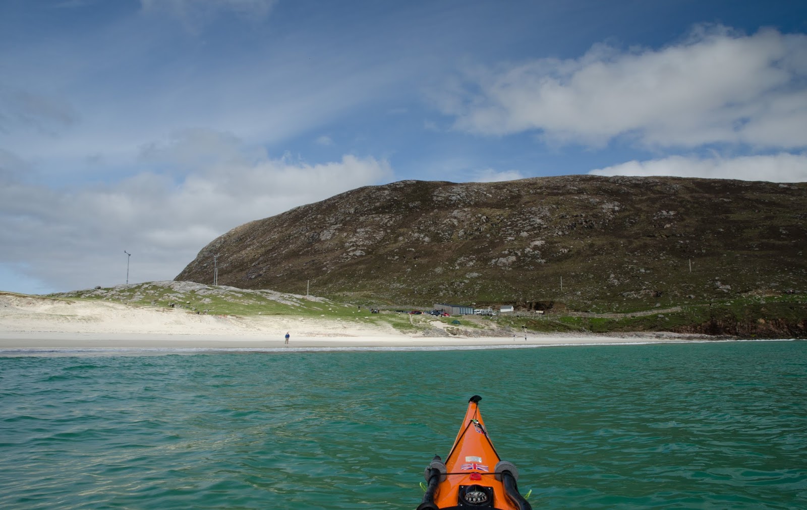
South of Tarbert, the road climbs over a lunar-like moorland landscape before dropping back to the sea on the west side of South Harris. The views get ever more jaw dropping, like here at Horgabost, looking over Seilebost towards Luskentyre......


...and here at nearby Traigh Iar (West Beach) which is more prone to surf than most as it faces directly into the Atlantic.  Each time we passed this beach it had good rollers coming in, great for surfers, not so good for kayakers!


Dragging ones eye away from the sumptuous widescreen views, there was plenty of interest in smaller scale too.  Thrift (Armeria maritima) also known as Sea Pink is one of my favourite wildflowers.  A real flowerof late Spring into early Summer it seems to relish harsh conditions and thrives on rocky coasts and right up onto the summit of mountains.


We'd enjoyed superb wildlife, views to make you gasp out loud and magnificent beaches....and it was still only mid morning!  We headed to a little gem of a place to buy a picnic lunch.  Croft 36 at Northton sells bread, pies and all manner of superb food from this tiny shop.  Baking and cooking are done in the crofthouse over the road and the food is placed in the shop; you pay using an honesty box.  Check out the website or Facebook page and if you're on Harris, don't miss a visit to Croft 36.  The food is healthy, local and excellent - the prepared meals were better than any of the restaurant meals we ate.  Don't leave it late in the day though, Croft 36's reputation means that they sell out quickly.

Well provisioned with pies, rolls and cakes, we were ready to enjoy the rest of the day.....

Thursday 21 June 2018

An enriching encounter at Huisinis


I left Loch Crabhadail with some regret, it's a special place.  The fresh breeze was behind me as I headed back down the Caolas an Scarp toward Huisinis.  The wind combined with an  ebbing tide had me fairly racing along and I decided to continue around to the south facing beach rather than land on the slipway and trolley my boat back over the machair.


As I left the comparative shelter of the channel the ebb and wind began to oppose a big swell.  Rubha Huisinis (Huisinish Point) is a pretty "out there" place, fully exposed to the open ocean; in fact apart from a few skerries the next landfall to the west would be in Canada....

It's been a while since I've paddled in an Atlantic swell; this was the last image I took for quite a while.  While there was no breaking waves, the swell was typically long period and very powerful.  The noise of the swell bursting on the cliffs of the headland was really something and once I settled a bit the situation was really engaging.  I was acutely conscious of how thin the margins are here; a remote headland in a big sea in an area with little realistic prospect of rescue if things went wrong - it focuses the mind wonderfully!


Almost abreast of the point I entered a strange area of calm water where the foam from the bursting swells was forming a broad line arcing out from the headland.  There was no change in either breeze or swell but this just felt more relaxed and I followed the line of foam until I got close to the source at the south end of the headland.  It would have been interesting to get close in to the point, but prudence kept me at least a kilometre offshore.


Turning into the south facing bay brought an immediate change, sheltered from both wind and swell.  It was a different world and a relaxing end to a few hours on this great stretch of the Hebridean coast.  A gentle landing and a short carry up the beach were a bonus too.


There's a new building at Huisinis together with an enlarged parking area;the Huisinis Gateway is a great initiative by the community-owned North Harris Trust.  There are toilets and showers within the building along with indoor picnic benches and information boards.  A site for camper vans is a little way along the road too, constructed to keep vehicles off the sensitive machair.

As we packed up and had a flask of tea before heading back along the road, our day was made even better when we spent some time chatting with another visitor.  A very sprightly 97 year old gentleman stopped to look at the kayak and to talk about how kayak design has evolved.  He'd served in the Royal Navy throughout World War 2 and had then been one of the instructors at the Outward Bound school in Ullswater in the Lake District.  He mentioned a fifteen year stint in East Africa too....it was one of those conversations where one feels enriched by having met such a wonderful person; I really regret not asking his name and learning more about a life well-lived.  That he was holidaying with his daughter from his home in Devon (just about as far away as you can get in UK) and was full of excitement at the trip was just remarkable.

Tuesday 19 June 2018

The black sheiling of Loch Crabhadail


The curving beach of Traigh Mheilein is a delight; a bold curve of dazzling white sand backed by dunes.  The seabed is also white sand for most of the width of the shallow Caolas an Scarp, and reflects light in beautiful aquamarine shades. I paddled along the length of the beach, then around Rubh an Tighe (point of the house) to land on yet another fine beach.


Even though it's comparatively sheltered, the beach at Loch Crabhadail (pronounced "Cravadale") clearly sees some big swell; the boulders at the top of the strand are of considerable size.  This is a quiet, empty spot, but it hasn't always been empty.


Between a small freshwater lochan and the beach, a distinctive pattern on the ground tells of different times when this land was farmed.  The system is known as rig and furrow, more commonly known as "lazy beds" (feannagan in Gaelic).

Scarcely can a more inappropriate term have been applied than "lazy".  The ground here is unpromising and poorly drained, so in order to grow crops it had to be modified.  The rigs were dug by hand and would have been built up using a mixture of sand and seaweed to make a usable gowing medium.  The furrows between the rigs helped to drain the soil and allowed potatoes and mabye some barley to be grown.  Usually the beds were re-made each year, sometimes at right angles to the previous year though here at Crabhadail they may have stayed in the same alignment due to the narrow site and the drainage to the lochan.  It must have been back breaking labour, but necessary to avoid starvation.  And, if that doesn't seem hard enough, when seaweed was in demand for making potash for glass and soap, many landlords banned their tenants from using it for fertilising the soil.

The line of an old wall can be seen at the end of the lazy beds, perhaps built to both shelter the crops from the wind and to keep out cattle.

What now seems an idyllic, lonely place would probably have held a couple of families - and although it's a beautiful setting, you can't live on a view.  This place was a sheiling, used mainly in summer by the people of Scarp and called Am Bhuaile Dubh (the black shieling).  Often it was the young folk and women who worked the sheilings, many Scarp and Harris men went away to work the herring fishery as the fish moved around the coast to the North Sea.


The remains of a couple of small houses can be seen, probably single roomed with low drystone walls and turf roofs.


The larger enclosures were used to confine cattle at night to stop them getting in at the crops; by day the beasts were herded away from the sheiling to graze.  There's a great deal of information about Scarp and the Crabhadail area on the Isle of Harris website -well worth a read.  As ever, these "rickles o' stanes" make me think about the people who made their lives here - all gone now.


Bogbean was flowering in the lochan, the waves on the beach were a gentle rhythm and above the crags a Golden Eagle turned on a thermal.  On this sunny day, Am Bhuaile Dubh and Loch Crabhadail were peaceful and evocative.  On another day just like today I'll come back here and camp in order to spend some time exploring and absorbing something of the place.

Thursday 14 June 2018

Huisinis - pure brilliant light

The first couple of days of our Hebridean holiday had been spent exploring Lewis from our base in Harris. The two are actually one island, but considered as separate entities.  The largest of the Scottish islands, Lewis and Harris are quite different from each other.


Where Lewis is fairly flat and has a landscape dominated by peat bogs, Harris is mountainous and has a rugged, rocky landscape fringed with jewel like beaches.  Harris itself is divided into North and South Harris, and is almost cut in two by the sea at Tarbert, the main settlement.  As elsewhere on the west coast and in the islands, the name "Tarbert" indicates a narrow neck of land between two bodies of water - the name derives from a Norse word meaning "draw-boat" and indicates a place where a longship could be hauled from one body of water to another across the land.

Great eagle country, North Harris has the highest population density of eagles anywhere in northern Europe and we were to see both Golden and Sea Eagles regularly, sometimes at close quarters.

But the thing that Harris is most notable for is the stunning quality of light.  We'd deliberately not gone to visit the coast while the weather was dull and wet, but the third day of our trip dawned bright and sunny, so we headed west...........


....to Huisinis, a crescent of white sand fringed with aquamarine and deep blue - this is what we'd come for!  The journey from Tarbert along a narrow, twisting single-track road takes much longer than the mileage would suggest - and this is a good thing.  Spectacular views, a landscape in parts otherwordly and wildlife (we had two good views of Golden Eagles above the road) are a great introduction, and the destination is well worth the effort.  Huisinis Bay faces south and was sheltered from a brisk northerly breeze; the sun was hot rather than warm which added to the impression of a slice of the tropics adrift in the Hebrides.


We strolled across the machair to the northern bay which has a good view up the Caolas Scarp.  The last time I was here was in 2011 and I was very much looking forward to more exploration of the area. A slipway gives access to the water, and this is was the only viable landing point when the island of Scarp was fully inhabited - these days there's just a couple of holiday homes and an occasionally used croft house.


I did my own bit of "draw boat" by pulling my kayak on a trolley over the machair path to launch from the slipway.  The northerly wind blowing down the Caolas (Kyle) an Scarp made for a bit of swell and a tricky launch but I got underway and headed out between Scarp, on the left of this image, and Harris.  I considered myself very fortunate - the kyle is shallow and in heavy weather swells break right across from shore to shore and travel the length of the channel, cutting off Scarp for days at a time. My first destination was the white sand beach on the right of the image.....


....which is actually the end of a curving beach backed by low dunes.  As I moved into shallower water the colours began to grow in intensity.....


......until they reached a crescendo as I landed on the shore and the sun emerged from behind high cloud.  This is the quintessential Harris scene, dazzling white sand and a sea of aquamarine, turquoise and violet shades.  It could scarcely get any more stunning....


...unless you add a brightly coloured sea kayak into the picture!  I spent a good time just strolling around on this beach, allowing the colours and the pure brilliance of the light to fully register.

Wednesday 13 June 2018

The "other" Calanais

For the last stop on our visit to some of the ancient sites on Lewis, we returned to Calanais, but not to the main standing stones.


The main stone stones were visible and impressive on the skyline, the cross shaped formation is actually easier to appreciate from a distance than when among the stones.


Along the road from the visitor centre, a minor road leads to a small parking area.  On the skyline another stone circle can be seen, reached by a walk across a field.  This elliptical circle is known as "Calanais II", neither circle or individual stones are as large as Calanais, but it's an atmospheric place.


The 18 stones vary from 2 to 3 metres tall and are arranged in an ellipse on a ridge very close to Loch Roag. A metre of peat was removed from the site in 1858 to reveal the full extent of the stones, and it is believed that a timber circle preceded the stone one.  As at Calanais I, the orientation of the stones seems to be on the moonset.


A feature of Calanais II is that the stones are slender and proportionally tall. A slab lies near the westernmost standing stone, pointing to the centre of the circle where there's the remains of a cairn.

Just 200 metres from Calanais II, there's yet another stone circle in this remarkable area.


Across a rough field you come to Calanais III, a double concentric circle.  The outer ring has 13 stones, while the inner circle has just 4 stones remaining.  There's no central cairn here, and once again the balance of interpretation is that the circle was oriented to the major moonset.


There are over twenty neolithic sites in this part of Lewis, a remarkable concentration.  For over 5000 years the stones have been part of the landscape, impressive but never dominating their surroundings.  It's entirely likely that despite the crowds at Calanais I, you'll have these two circles to yourself - which adds to the experience.

As with all such sites, the Calanais stones inspired us to reflect on the community effort of construction, the stones in use and what's been lost in our understanding of the world.

Monday 11 June 2018

Blown away by Dun Carloway

From Calanais we headed north along the road which hugs the coast of Lewis to a visit a place which I'd been really looking forward to, possibly more so than the stones we'd just seen.


Dun Charlabhaigh (Dun Carloway) is visible from a long way, and was meant to be seen.  An iconic outline on a prominent ridge line, even in a partially ruined state it's a striking sight.


Dun Carloway is a broch; a type of fortified residence unique to the north of Scotland, the Northern Isles and Western Isles.  A "Broch" can be described as a tapered round tower construction with more than one internal floor level, and the walls are usually galleried internally.

Built around 100BC, Dun Carloway was constructed at a time when brochs were beginning to be replaced by buildings which required less in the way of resources, particularly timber.  It may have been in use as late as 1000AD, which is quite late in comparison with other brochs.

Even in a partially ruined state you can clearly see the two walls with galleries in between.  The ruin stands nine metres tall at its highest point and is likely to have been somewhat higher.  It would have been had a conical timber roof and timber floors at each level - a significant use of what's a scarce resource on Lewis.  Much of the stone from the side which is easier to access has been re-purposed into constructing nearby blackhouses in the past, before the site became one of the first to be taken into national protection under Historic Scotland.


The quality of construction is astonishingly high.  No mortar was used, the walls are drystone built with hardly a gap - the building of a concentric, tapering tower of stone in this way must have required skill and vision; and must have been commissioned by a person of significant power.


The stairways between floor levels spiral up inside the walls themselves and are still in remarkably good condition.  You have to remind yourself that the brochs date from the Iron Age, but the folk who built this were far from primitive or uneducated.  Given that Dun Carloway has stood here for over 2000 years, the fact that internal stairways are intact and usable is nothing short of astonishing; how many modern structures will last that long? 


The graceful taper of the walls is carried through internally in the galleries which run around each level.  It's likely that livestock could be housed at the ground level with human occupants living above.  Brochs are believed to be part defensive refuges and part impressive statements of power and control - several were probably used as refuges from Norse raiders well after they had ceased to be permanently occupied.


Supporting stone slabs were used higher in the structure to strengthen the whole - the more one explores the more the skill and vision of the broch builders becomes evident.


Dun Carloway is looked after by Urras nan Tursachan (Standing Stones Trust) who also look after the stones at Calanais and there's a small visitor centre below the hill which is built to echo the broch itself and is partially underground. Access to the broch is free and you can explore the inside by going through a small gate at the ground level entrance.  We were blown away by Dun Carloway


We were blown away by Dun Carloway.  In contrast to Calanais there was just two other people around and we were able to glimpse the power, symbolism, the setting of the broch and the craft of its builders.  If you visit Lewis, don't miss Dun Carloway!

Wednesday 6 June 2018

Calanais stones


There's not much doubt that almost everyone who visits Lewis will make the journey to the west of the island to see the standing stones at Calanais.  We arrived early in the afternoon, hoping to avoid some of the bustle of tourist coaches.

One of the best known of Britain's standing stone formations, the main stones here are just one of over 20 monuments in this part of Lewis erected between 3000 and 4000 years ago.  The main site is known as Calanais (Callanish) 1 and consists of some 50 orthostats in a complex arrangement of circle and avenues.  The central stone circle and northern avenue are believed to date from 2000BC with the other avenues and a "tomb" within the central circle dating from about 1500BC.


In plan view the stones form a similar pattern to a celtic cross with the radial avenues leading either to or from the central circle of 13 stones.


The labour and planning required to erect the stones must have been enormous for a small community and it's clear that this was a place of some significance.


Erected in the Neolithic period and in use as a ritual site right through the Bronze Age, the stones are believed to have been a ritual site and have connections with lunar observations, including the lunar standstill which occurs every 18.6 years - the moon appears to stand on the surface of a nearby ridge when seen from the centre of the circle at this time.

Despite the wet weather and a visit planned to coincide with lunchtime there were still large numbers of folk visiting this justifiably famous place.  Below the low hill on which the stones stand there's a visitor centre, cafe and busy car park, all of which detracts slightly from attempts to just stand quietly and absorb the site.


The central stone is some 4.8 metres tall and weighs around 7 tonnes.  It is actually 0.8 metres from the "true" centre of the circle.  The stones seem to have fallen out of use about 800BC, and since then had accumulated a covering of some 1.5 metres of peat which was removed during archaeological excavations in 1857, revealing the extent of the site.


The stones themselves are a rough, granular grey rock banded and speckled with black - quite at home in the landscape.


In its setting on a ridge, Calanais is a visible and evocative site - but it's not the only circle hereabouts and we'd visit others later in the day.  Overhead the promised improvement in the weather was arriving and we'd not see a drop of rain for the remainder of the week.  Next on our itinerary was another place we've wanted to visit for a long time.

Tuesday 5 June 2018

A prolonged shower in Lewis


Our Hebridean holiday was scheduled for the second half of May, which we hoped would give a reasonable chance of good weather.  An early start from home saw us arrive in Ullapool in good time for the morning ferry to Stornoway.  The MV Loch Seaforth is a fine vessel, now well established on this route, for which she was specifically built in 2014.  At 8680 tonnes and 118 metres long she's the largest vessel in the Calmac fleet and can carry 700 passengers and 143 cars.


We left Ullapool on a bright and pleasant morning, but armed with a forecast which showed strong winds by the evening and then a passing front which would bring rain for a time.  After a very comfortable crossing of the Minch we disembarked and drove south through Lewis to Harris (the two are actually one landmass but considered very much as separate islands) to the cottage we'd rented in rapidly strengthening winds.  By evening the rain had arrived - and continued for 43 hours.  In these parts this is known as "a shower"........


The following day was Sunday; and pretty much everything on Lewis was shut.  The tradition here is very much steeped in the Free Church (or "wee free" as it's sometimes known). This Presbyterian and evangelical church is a quite austere form of Christianity - and Sunday is kept as the "Lord's Day" when nothing except worship should happen.  There continues to be opposition to any business or organisation wishing to operate on a Sunday in this island, and it has to be said that churches are well attended

We took a drive around the north of Lewis, much of which is a huge raised peat bog.  The wet conditions seemed to add to the austere nature of the landscape.  I confess that I don't have the resilience of spirit to be able to live and to thrive here.


As it was still raining into Monday, we decided to have a day visiting some of the celebrated ancient sites of Lewis, but the first place we arrived at was somewhat more recent in origin.  The Norse Mill and Kiln near Shawbost is a restored example of horizontal mills which were once active all over the island.  


The water was let in via a lade (channel) to turn horizontal paddles which powered the upper millstone, grinding corn which was fed in by a hopper.  Remarkably, the Shawbost mill only ceased operation in 1930 and similar mills remained operational until 1945.


The building opposite the mill is a kiln where grain could be dried using a small fire.  The construction is very traditional and may show Norse origins - hence the name.


On the moorland approach to the mill, a discarded millstone lies by the side of the path.  At this point in the day the rain was still falling, but with a forecast for a dramatic improvement by mid afternoon.  Even in these conditions, there was the occasional splash of colour though.....


We thought this to be Lady's Smock, or Cuckoo Flower (Cardamine pratensis) which also grows in a damp part of our garden at home.  We were careful not to pick any of it - which in the month of May is considered very unlucky and is associated with being bitten by Adders in a tradition stretching from northern Europe to France!


Bog Bean (Mentyanthes trifoliata) was beginning to flower in many of the pools.  A common aquatic plant, it seems to thrive here; and Lewis has an abundance of pools for it to populate.  It's a pretty plant and has many medicinal applications.


Perhaps the brightest thing around were the abundant Marsh Marigolds (Caltha palustris) one of the most common wildflowers of the Outer HebridesDespite the rain, we were finding plenty of interst and we hadn't yet got to the places we aimed to visit.....