Showing posts with label archaeology. Show all posts

Monday, 12 September 2016

The "stone men" of Saddell Abbey

After breakfast at Saddell Bay we took down our tents and packed up our boats on the shore. One of the pleasures of sea kayaking for both Douglas and I lies in exploring a little of the places we kayak to, and close to where we'd camped was the ruin of the historic Saddell Abbey which we hoped to visit before moving on.


Walking along the track above the shore we first passed Saddell House, one of the properties owned by the Landmark Trust.  The Trust was formed in 1965 with the aim of preserving historic buildings which weren't in the care of either the National Trust or Historic Scotland (then part of the Ministry of Works).  The buildings weren't to be preserved as museums though, one of the key aims was to enable public enjoyment of the properties and in many cases this has been achieved by offering them as holiday rentals.  Saddell House was built in 1774 by Colonel Donald Campbell who had earned military fame as well as considerable wealth in the Indian service.  Built in a light and airy style , one of the most distinctive features of the house are the large chimneys.  In 1899 a fire in one of the chimneys spread to the attic and burned the roof.  Rebuilt almost straight away, it remains an impressive house.


At the western end of the curving bay is the older Saddell Castle, another Landmark Trust property. Built in 1508 by the Bishop of Argyll at a time when bishoprics were hereditary or granted by royal favour and the bishop's robes were interchanged with chain-mail, the castle was described in a contemporary document as "A fair pyle, and stronge".  A fairly typical Scottish tower-house, by 1600 it was held by the Campbells and continued in the ownership of that powerful clan for 400 years.


A long driveway leads from the castle up towards the public road which had a cool, green atmosphere on this morning of sunshine and showers.


The damp climate and shady wood give ideal growning conditions for mosses and fungi which were growing in profusion along the banks lining the drive.


It's a short walk from the end of the castle drive to the ruin of Saddell Abbey, of which comparatively little remains.  Somerled, Lord of the Isles granted land here to Bishop Malachy of Armagh in 1140 to build a Cistercian abbey and work commenced in 1148, the monks came from Armagh also.  Somerled's son Ragnald re-endowed the abbey in 1160 and it remained in use for probably another 350 years, finally being abandoned some time after 1493 when James IV took control of Argyll from the Lords of the Isles.


The ruin lies on a slight rise in the midst of a graveyard. the only really identifiable parts are the interior of the choir and the north transept, all the rest is gone.  But actually it's the graveyard and the stones within which are the main historical interest at Sadell Abbey.


Housed in a very well-made shelter of stone, glass and wood which sits well in the context of the site are a remarkable collection of stones, grave-slabs and effigies which marked burials at Saddell and show what an important place it once was.  On this fragmented stone a highland Birlinn (galley) and a sword are clearly marked, the means by which the Lords of the Isles exercised power.


There are twelve grave-slabs displayed back-to-back within the shelter, most of which are believed to have been carved on Iona and transported here to mark the graves of great men and churchmen (women are rarely depicted on such stones).  All are thought to date from around 1300-1400 and are beautifully made with distinctive Celtic motifs which may once have been painted.


The most striking of the stones are five grave-slabs bearing life-size effigies; two probably represent priests and three are effigies of Highland Lords in full armour.
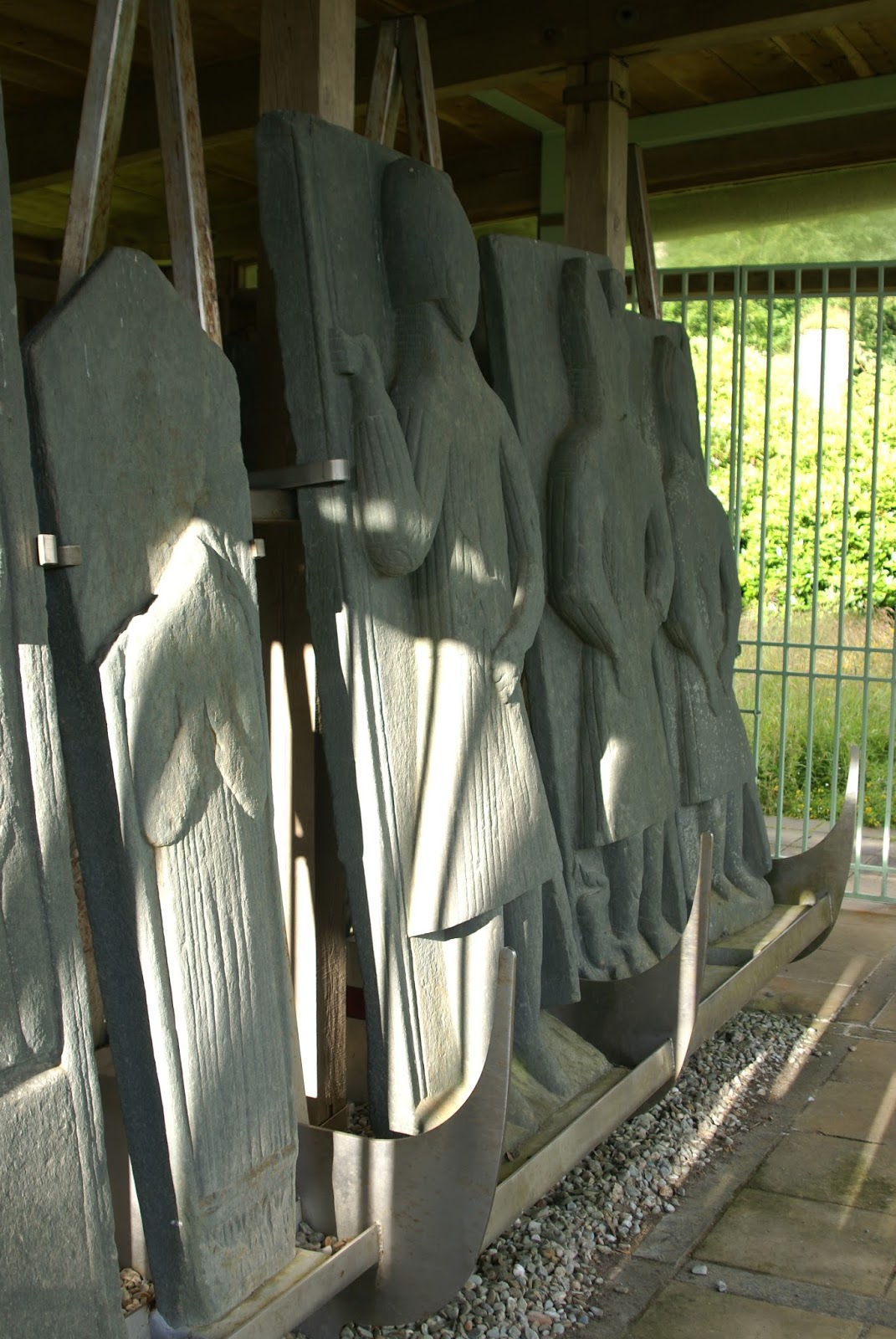


The detail and craftsmanship with which these "stone men" were carved has endured over 700 years - it's possible to get an impression of how the nobility of the day would have actually looked.  In most cases the faces are somewhat blank, but there are other fine details which emerge as the stones are examined more closely.  On two of the stones, figures are displayed at the shoulder of the which may represent wives, and at the feet of the central figure in this image an inverted figure of what appears to be a dead child is depicted in quite explicit detail.  A faded Latin inscription states that this effigy is of Neil McNair, and was commissioned by his son Donald - it's a fascinating window into a past inhabited by identifiable people.


Items of clothing and weapons are carved in superb detail, right down to the decorative elbow guards worn by the Lords and individual scales of chain-mail.  Weapons are carried by all (including the clergymen) and some of the slabs seem to have been carved with provision for an actual or decorative spear - the right hand of this Lord clasps an empty socket with a recess in the stone showing where the weapon would have been.

The shelter housing the effigies has been thoughtfully designed to allow light to flood the stones, enhancing the details.  A nice design touch can be found on the metal frame containing the stones where the separating uprights are made in the style of a Birlinn's bow.

We found the "stone men" of Saddell Abbey fascinating; the site is very well worth a visit.  I'm not sure whether Sir Antony Gormley visited the Abbey when designing his "Land" series of sculptures, but there's maybe a hint of these figures in his work nearby which looks out to Kilbrannan Sound.

Sunday, 31 January 2016

Rhynie Symbol Stones

Below the slopes of Tap o' Noth and its summit hillfort lies the village of Rhynie.  A quiet and unassuming place, archaeologists believe that at one time Rhynie was a major centre of Pictish power.  A glance at the map shows the amount of standing stones and stone circles in the surrounding area, most of which pre-date the Picts, but in 2011 a dig near to the spot where the "Rhynie Man" was found revealed the traces of a substantial fortified settlement.  Some of the artefacts recovered were of Roman origin and alongside other research has led to the suggestion that Rhynie was a royal Pictish site.

The Picts have proved elusive for historians; the word most often used when referring to them is "enigmatic".  Believed to have been both ethnically and linguistically a Celtic people, they controlled much of the north and east of what is now Scotland for at least 600 years.  Despite this prominence, comparatively little is known about them. They left no chronicles or written records and much of what is known of them comes from Roman, Gaelic and Norse sources; peoples they were in conflict with.  The Pictish language remains only in echoes down the centuries, in personal names such as Kenneth and Alpin, and in identifiably Pictish place name roots such as "Pit" or "Peth" (as in Pitmedden and Perth), "Aber" (as in Aberdeen) and "Lhan" (as in Lhanbryde).

The most tangible remains aside from fortified sites such as Tap o' Noth and Burghead are undoubtedly the several hundred Symbol Stones discovered across what was once Pictland.  Carved with great skill and artistry, most feature a range of uniquely Pictish motifs, often abstract or animistic and sometimes with representations of domestic objects. "Enigmatic" to the modern mind, the fact that the symbols occur on stones across the whole of Pictland from Shetland to the Forth implies that they would have been understood by all Picts.  A great resource for discovering more about the stones themselves and the Picts as a people is Historic Scotland's "Pictish Stones" website.

Rhynie has a good collection of symbol stones (aside from the Rhynie Man which, incongrously, is located in Aberdeen city council's HQ).  There are three stones in a shelter near to the present day churchyard, with a fourth in a nearby field.  


The light wasn't so good for photography when I visited on a grey November afternoon. This, the  largest stone, is 1.3 metres tall and carved with a "beast" possibly representing a seal or an otter combined with two typically Pictish abstract symbols- the double disc and Z-rod and a mirror and comb.


An information board nearby has clear representations of the carvings; the one in my photograph is at the lower left.

The fact that the meanings behind the symbols are uncertain adds to the experience of visiting the stones; I find Pictish sites fascinating and hope to explore more in the coming months.

Thursday, 28 January 2016

Tap o' Noth hillfort


 The initial and enduring impression as one enters the Tap o'Noth hill fort is the sheer scale of the site.  The walls enclose an area approximately 100 by 30 metres,  making the site around the size of a football pitch.  The aerial view on "Canmore", the digital archive of the Royal Commission on the Ancient and Historic Sites of Scotland can be used as our guide around this impressive place.


 Although tumbled, enough remains of the walls to gain an insight into what a mighty fortress this would have been, the tumbled remains of the walls are 6 metres wide and 3 meres high  The organisation of labour to build and to occupy Tap o'Noth must indicate an advanced people with a structured society and the means to both construct sites like this and sustain themselves at the same time.  Archaeological finds here include an axe head dated around 2000BC-800BC and a piece of bronze horse harness dating to around the 1st-3rd century AD.  This would indicate that the site was probably in use from the Bronze Age and continued through to the Iron Age Picts, perhaps starting out as a small fort before being greatly expanded.  The word "Noth" is thought to have a Pictish origin and possibly has the meaning of "looking" or "seeing" - very appropriate given the wide ranging views from the summit.


 The fort site has a stone lined cistern well, clearly visible on the aerial view as a dark depression near the southern end of the enclosure.


 Parts of the wall have been vitrified by intense and prolonged heat, these vitrified sections are mostly concentrated at the north western end wall.


Debate continues amongst experts as to what vitrification represents, destruction or a deliberate strengthening of the walls.  There's some more about vitrified hillforts here, and as I visit more vitrified forts it seems to me to be logical that this represents a deliberate construction technique rather than a destructive one.


But the fort itself is just the crowning glory.  Lower down (pretty much at the divide between the grass and heather in this image) there was another stone rampart running right around the hill.  Remains of over 100 house platforms have been recorded in this area, with a definite clustering on the northern and northeastern slopes, sheltered from the prevailing wind and weather by the hill and the fort.


The line of the lower rampart can be seen in this image.  The whole site is a staggering 21 hectares in area; this is no mere defensive bolt-hole or even a status symbol built by an individual - it looks and feels more like a major centre of power; which is what it is believed to have been.


From the northern slopes of the hill a series of terraces exists in places, and occasionally the possible outline of a building.  From here the fort wall looks very impressive - how much more so must it have looked when in use?


The effort involved in the building of such walls must have been enormous.  It would be a mistake to think that these Iron Age people were in most senses of the word "primitive".  Named "Picti" (painted people - probably deriving from the habit of tattooing) when the Romans encountered them in the late 200's AD the Picts were already a force to be reckoned with.  A sophisticated and organised society who farmed, kept livestock, indulged in art and sculpture and were fearsome warriors, they dominated northern and eastern Scotland until around 900 AD when the Picts were defeated and absorbed by their Gaelic Scots neighbours.


As I stood in a raw wind at the wall of Tap o' Noth,  my  thoughts of the warriors who would once have peopled this place were interrupted by a flat roar......


....the signature noise of a modern warrior class - the crew of a Tornado fighter-bomber streaking past in a hard turn. 

Sunday, 12 April 2015

An echo down the centuries from Eilean Fhianain


We took a last look back up Loch Shiel before we turned the corner at Camas Drollaman.  From this point the mountains which hem in the upper loch so closely and give it a fjord character begin to fall back and gradually there is a more open character to the scenery.  To have experienced the loch in such still conditions for two days was a rare treat and we wondered whether we could ever match these two days on future visits to Loch Shiel.


On the low grassy ground near the very point of Camas Drollaman we came across this Ringed Plover (Charadrius hiaticula).  A member of the Plover family and related to Lapwings, these dapper little waders are beginning to breed on more inland sites in addition to their more usual sites on sand and shingle seashore.

The UK breeding population of Ringed Plovers may be less than 6000 pairs, though numbers are boosted in the winter to about six times this figure with birds from Greenland and Canada.  I'm taking a guess that this this particular bird is a resident as it was in breeding plumage; the easiest way to tell the difference is that the bill turns from black in winter to bright yellow-orange with a black tip.

Ringed Plovers lay their beautifully marked eggs in a shallow scrape in sand or gravel.  If the nest site is approached by a predator (or a sea kayaker), the adult will try to lure away the threat by feigning a broken wing. If encountering this display, it's wise to keep a very close watch on where you put your feet as the eggs are so well camouflaged.  Seeing this display in Spring and early Summer on a beach at you intend to camp should be a cue to move on somewhere else to avoid disturbing the birds.  Mike, Douglas and I had last seen nesting Ringed Plovers on Arran in the previous summer and on that occasion had stayed well below the tideline during our second breakfast in order to avoid disturbance.


After paddling around Eilean Camas Drollaman, a wooded island which has evidence of a "bloomery" once used to smelt iron, we headed for the narrow twist of the loch containing Eilean Fhianain (Finan's Island).  We landed next to the small stone jetty, which wasn't the easiest landing due to the water deepening quite quickly immediately off the shore.

Finan was an early Celtic saint who is believed to have lived from around 520 to 600AD.  Details of his life are sketchy but he seems to have followed Columba from Ireland and became Abbot of a small monastery on the island now named after him, but which is also known as the Green Island.  He is believed to have evangelised much of Argyllshire, but considering that his name crops up all over Scotland - as well as the obvious Glenfinnan and Kilfinnan, there is a St Finzean's Fair in Perth and a Finzean as far away as Aberdeenshire, he must have travelled extensively

Known as "Finan the Leper" from the disease which afflicted him, he appears to have favoured small islands on lochs; he is also recorded as the founder of at Inisfallen on Lough Leane in Ireland's County Kerry.  Finan died, it is thought, at Clonmore in his native Ireland.


I've often thought that the early Celtic churchmen knew a good spot when they saw one, and the island which Finan chose as his base is certainly that.  A grassy green hump formed of glacial sand and till, it sits away from the shadow of the high hills and has great a view up Loch Shiel and down to the sea at Moidart.  Crucially for the purposes of the early church it sat in a prominent position on the sea and land routes through Argyll, Sunart and Moidart.

The first of the daffodils were opening on the sunny slopes as we climbed up to explore Finan's island, a splash of bright yellow against the late winter colours elsewhere.


The top of the island is largely given over to a burial ground; some of the graveslabs here are very old, probably early mediaeval, but though some of this group of crosses appear very old they date from the 18th century.  The island was a traditional burial place for the chiefs of Moidart, indeed it may have already been in use as a burial place when Finan arrived in the 6th century.  The island is still used as a place to commemorate the dead, we saw several recent stones marking the interment of ashes - a continuity of use which would surely please Finan the Leper.


A very fine Celtic cross monument stands in a prominent spot overlooking lower Loch Shiel, commemorating  a Reverend Charles MacDonald, priest of the diocese of Argyll and the Isles who also wrote a history of Moidart and of Clanranald.


The stonework on the monument is very fine indeed with celtic motifs, designs and a range of tail-casing animals.

The ruins of a stone chapel sit in a small hollow high on the island, dating from about the 16th century.  It was the centre of worship for those of the Catholic faith but fell into disuse in the 1700's, possibly in the bloody aftermath of the 1745 rebellion.  The visible ruins themselves replaced a wooden chapel which was probably built by Allan MacRuari, a chieftain of Clanranald who had a distinctly violent reputation.

But predating even this is a remarkable artifact - and one which you might reasonably expect to find in a glass case in a musem rather than exposed to the elements in this place.


On the roughly formed altar slab, sitting next to a weathered stone cross is a bronze bell which dates from the 10th century.  It takes a moment for the significance of the thing to sink in - a seamless bronze hand-bell which is in excess of 1000 years old on a small island in Loch Shiel.....

It has survived the ravages of time, of the vikings and all the tumult of the years since to remain intact on the altar here, secured with a small chain.  There are of course stories telling of the curse which will befall any person removing the bell which must have been persuasive enough for the authorities to leave it in place.

We can vouch for the fact that the bell is fully functional, an experimental ring brought a clear tone which echoed back in the still morning air and caused deer over a kilometre away on the mainland to raise their heads - it's an echo which has been heard here down ten centuries.


Eilean Fhianain is a real gem of a place and very well worth a visit.  We spent an hour or so exploring the island and its history before returning to the jetty to make coffee prior to setting out again on our route to the sea.   To have simply paddled past, intent on racking up distance would have been a great shame, one of the advantages of paddling with like-minded friends is that small explorations such as this are a real highlight of the journey as a whole.

From Eilean Fhianain we would paddle the shallow lower part of Loch Shiel and we now started to think ahead to our transition from fresh to salt water.

Thursday, 9 October 2014

Old Keig stone circle

The north east of Scotland is rich in ancient monuments, standing stones, circles, hillforts and castles.  The most enigmatic, mysterious and impressive are the perhaps the stone circles - voices from our past in stone.

Aberdeenshire has the highest concentration of stone circles anywhere in mainland Britain, many of which are of a unique design found nowhere outside an area bounded by the rivers Don and Deveron - the Recumbent Stone Circles. There are several recumbent circles within a few kilometres of the house, and on a raw and grey spring day we made a short drive to see one circle which we'd not previously visited at Old Keig.


Set on a ridge with views over the Howe of Alford, the circle now sits within a shelter belt of beech and pine trees.  The site was built up to make a level platform for the circle, now bounded by a much more modern drystone dyke.  Excavations have revealed that the interior of the circle had a bank of stones and a central cairn bounded by a semi circle of kerb stones; this was a complex construction.  Dated to the Neolithic, remains of pottery and burnt bones have been found buried near the central cairn.

The characteristic recumbent with its two flankers remain, but only a few of the orthostats which would have formed a circle diminishing in height are still intact.


Massive and impressive, the big stones have a subtle geometric pattern common to every one of the recumbent style circles.  The recumbent itself is misaligned with the circumference of the circle by 15 degrees, tracing an arc-axis towards the centre, making the "circle" a subtle spiral.


This is the view from the centre of the circle looking directly over the recumbent.  The alignment of these  monoliths is very significant - they were arranged with astonishing precision.  The recumbent brackets 27 degrees of arc when viewed from the centre of the circle and the midwinter sun sets directly over the middle of the stone.

This is impressive enough, but there's more.  The celestial phenomenon of lunar standstill occurs every 18.6 years and the circle is aligned to it - the midsummer moonset at the major standstill sets precisely over the left edge of the recumbent in the angle formed by the left flanker while the midsummer moonset at the minor standstill sets precisely over the right hand edge of the flanker in the angle formed by the right flanker.  This is surely not coincidence; I have to believe that this astonishingly accurate positioning was by design.

Old Keig's circle is 20 metres in diameter and is noted for the size of the recumbent - the largest of any of this style of circle.  It's a huge block of sillimanite gneiss and the rock type is significant because it wasn't quarried locally.


This gigantic block was quarried from somewhere in the valley of the River Don - some 10 kilometres from the site.  It was worked to make a completely level top face while the bottom of the stone was worked into a "keel" shape to better sit in the ground.

Then this enormous stone measuring 5 metres long by two metres wide by two metres deep and weighing 53 tons was dragged 10 kilometres to this site - the last kilometre up a slope of 1:14 gradient.  The work involved must have been staggering. 


The flankers are carefully placed against the recumbent - the small rocks under the edge are believed to have been positioned much later.


It's only when one considers the work and care which went into this and so many other circles that the true import of what stands here becomes a little clearer.

Far from being primitive savages, the folk who designed and made these circles in the Neolithic - the Stone Age - must have practiced agriculture; only a settled population could have undertaken such a huge project.  Some of them at least must have been able to perform complex observations and mathematical equations in order to work out the positioning and the subtle geometric arrangements.  They must have been a sophisticated enough folk to be able to organise labour (whether voluntary or forced we'll never know) and to use tools, ropes, levers and all the rest in order to move and position huge stones. They must also have been numerous enough to move the stones; it's been estimated that at least 100 people would have been required - or a combination of people and oxen.  As the circles are comparatively closely spaced there must also have been numerous similar communities.

And they must have had time.  The agriculture practiced must have allowed sufficient margins of time to create monuments such as circles and standing stones.

The purpose of the circles remains something of a mystery; were they observatories, places of worship, places of sacrifice even?  Were they used by an exclusive elite or were they a communal statement of the sense of place of the society which made them? Certainly they were places of power, and of powerful symbolism - they remain that to this day.  There is an indefinable presence among the circles and stones - an echo down thousands of years, a sense of mystery and wonder.  In this, the circle builders were spectacularly successful.

We came away from the Old Keig circle with renewed wonder and admiration for what these folk achieved - and maybe that too was part of the purpose of the circles.

Wednesday, 18 September 2013

A two thousand year old view - the Broch of Loch Ardbhair


After leaving Loch Shark I crossed back over the mouth of Loch a' Chairn Bhain and along the coast, where the map indicates a channel between the mainland and Eilean Rairaidh.  ou really have to believe in the map, because the channel seems hardly to exist, but it's there!

Beyond the island, the mouth of Loch Ardbhair seems to be blocked by a rocky arm, but this channel is also there and leads via an "S" shaped entrance into a shallow loch about 1.5km long and 600 metres wide.  Right at the head of this loch, the map has marked on it "Broch".  Well, this was certainly worth exploring further....


On a small tidal island, the remains of a circular structure can clearly be made out.  There seems some debate as to whether this structure was a true Broch, or some other kind of building, referred to by the generic term "roundhouse".  Brochs appear all over the north of Scotland and particularly in the Northern Isles, and mostly take the form of a tapered round tower type construction with massive walls with well fitting stones, galleried inside and with more than one floor.  They mostly date from 600BC to AD100, a quite considerable period of development.

This "Broch" (also referred to as "An Dun" - the fort) has a single skin drystone wall 8 meters in diameter and up to 3 meters thick at its base.  The quality of construction isn't that good in comparison with some Brochs, but it seems meant to have beeen a defensive or protective structure of some sort.


A drystone dyke, noted by the surveyors as a "causeway now partly displaced" runs down the hill and into the water, emerging at the base of the outer wall.  Whilst I don't have the level of insight that specialists in ancient structures have, I couldn't see this a primarily a causeway.  When looking at ancient structures or ruins I try to put myself in the place of the folk who built and used it.  While this could have had use as a means of access, it's quite narrow and would have been precarious; perhaps it had another use as a means of keeping back some water at the head of the loch on the falling tide, maybe as a fish trap or holding area?


The site of this structure probably hasn't changed that much since the Broch builders constructed and used it nearly two thousand years ago; this would still have been a shallow, Curlew-haunted arm of the sea, hidden from view to those who didn't know it was here.........


....and this view to Quinag from the narrow entrance way can hardly have changed at all in two millenia.  This continuity of place occupied my thoughts as I left the tiny island and headed back out of Loch Ardbhair to the sea.

Monday, 14 May 2012

Boom!


Continuing my paddle eastward along the Moray Firth coast, a line of three caves above the shore marks the start of Clashach Cove.  Also along this stretch  is the Sculptor's Cave which has a record of occupation from the Bronze Age to the 19th century.  It is best known for the Pictish carvings which adorn the walls, and also due to the fact that the remains of severed children's skulls were found buried near the entrance and date from the Bronze Age.

The seabirds are returning to the cliffs here; Kittiwakes are already on their nests and the others will soon follow.  Already the clamour and smell of the colonies are beginning to dominate the cliffs.


Whilst passing Clashach Quarry (where early reptile footprints have been fossilised in the sandstone), I could see a periodic eruption of spray from the shoreline.  From closer in the source of the commotion could be seen.

A shelf of rock with a slightly overhanging face in the corner of the cove is normally above the tide line.  The high Spring tide had put the shelf's outer face in the firing line of the swell and a small group of people with cameras were gathered on the shore to watch the fun.  I manoeuvred into a position where I could be safe but quite close......


Showtime!  The larger sets of swells were erupting against the face with impressive force


Spray was being hurled up well over 10 metres into the air and the concussion from each of the big swells  could be felt through the hull of the boat.


The bigger sets of waves were arriving every few minutes and I watched through three or four sets.  The last one included a monster, hitting the shelf with a hollow boom and scattering the folks on the shore as it crashed over the shelf.


The paddle from Clashach Cove to Hopeman was altogether less dramatic, and soon I was landing on the beach inside the harbour which was giving shelter from both wind and waves