Saturday, 7 May 2011

Getting the hump above the woods of Glen Tromie

Towards the end of a very fine spell of weather, I set out from home to travel to Druimguish to do some hillwalking above Glen Tromie (Gaelic: Glen of the Elder trees).  I'd use my bike to get up the glen to the start of the walk.


Glen Tromie is attractively wooded in its lower part with Willow, Birch, Oak, Rowan and of course Elder all being prominent.  Higher up the glen  conifers dominate but fortunately not in monoculture blocks of Sitka Spruce.  The River Tromie flows from the linked lochs of the Gaick Pass and enters the Spey below Druimguish.


There are extensive grassy flats higher in the glen and a couple of abandoned cottages.  The hill which appears to block off the head of the glen is the delightfully named Mullach Coire na Dearcag (Summit of the Corrie of little berries).  I left my bike near this spot and set out up the hill.


A steady climb took me over the subsidiary summit of Meallach Bheag (Little Hump) and onto the Corbett of Meallach Mhor (Big Hump).  Both summits are well named, being just as the names describe.  The view is very extensive; to the northeast the Cairngorm summits were clearly visible, and to the west, the central highland giants of Ben Alder and Creag Meagaidh stood out well.

The Window on Creag Meagaidh was very prominent. How simple it looks to find in this view, but it's not so easy when on the hill itself with the weather down; and finding it is key to a safe way off the summit plateau.  The Post Face was also prominent, containing hard climbs pioneered by Dr Tom Patey


The higher ground still has the bleached tones of winter, but Spring has arrived even here.

The vegetation is largely short heather, parts of which have been burned in strips to provide young shoots for Grouse to browse.  There were more Cloudberry (Rubus chamaemorus) flowers on this hill than I've seen in a long while.  The plant flowers quite infrequently in Scotland; perhaps the exceptionally dry Spring weather has suited it.  Whilst taking this photograph, a lizard scampered over my boots, seemingly without noticing me at all.


To the south I could look into the Gaick Pass, a traditional right of way goes through here linking Speyside with Atholl.  It makes a fine walk or mountain bike route, and has a number of legends attached to it; as well as probably the first recorded avalanche deaths in Scotland when a notorious recruiting Sergeant and his party were avalanched in a hut in the heart of the pass.


I headed north along a broad ridge above Glen Tromie for about 5 km to a trig point on the small summit of Croidh-La.  The view from here is great, a panorama of the Spey valley and the towns of Kingussie and Newtonmore.

A steep descent led me back to the bike and a leisurely spin back down Glen Tromie, with a nice sighting of an Osprey as a bonus.

The route is 25 kilometers in total, about half of which can be cycled; the ascent is 710 metres.  You'll need OS Landranger sheet 35 (Kingussie and the Monadhliaths).  Most of the hillwalking guides recommend a route which uses a bike all the way to Bhran Cottage at the foot of the hill followed by a straightforward up-and-down walk.  I feel that the route I used is a better one, a pleasant ridge walk with very good views.

Thursday, 5 May 2011

An entertaining crossing to Bute


Moving out toward the tip of Ardlamont Point, the island of Bute became visible beyond.  The wind was blowing directly from the island, funnelled through the lowest part of Bute across Ettrick Bay where I hoped to land.  I took a final photo, battened myself down and headed out.

The wind, waves and some wind against tide along and just beyond the point gave some of the most challenging conditions I have ever paddled in.  A short, vicious swell was being punched up as the water shoaled approaching the point itself, and was combining with an incoming swell from the south east.  The boat was pitching and slamming wildly, sheets of spray and water being hurled back across me.  The swells were head height or higher, tumbling and breaking from different directions. This demanded absolute concentration - one small mistake here would be punished instantly. 

I was barely making progress around the point, but found myself actually quite enjoying the ride.  At worst, I could hold the boat head into the the sea and be blown back around the point if I needed to.  Of course as I gradually won clear and into the Sound of Bute, this option wasn't available; being blown backwards would have seen me on the lee shore.  Not good.  Equally, although I could cope with the sea from ahead, going down-sea in this would have been much more difficult.

Fortunately once clear of the point the confusion of different swells settled into a steady direction, and though still large, steep and short period was much more predictable and manageable.  I settled down for the battle, a simple enough game of physical and mental endurance against a relentless wind.  The boat was riding well over the sea, and more than once I was glad that it was loaded with camping kit as more than half of the fore end hung up over a particularly nasty swell; being flipped backwards was not a prospect I relished!

Eventually I won into the wide arms of Ettrick Bay and gradually the swell had receded as it had less fetch to kick up, but if anything the wind strength was higher here as it barrelled across Bute.  A quick re-evaluation of transits and I decided to head slightly north to the beach at Kildavanan, which forms the northern arm of the bay.  Here I'd get more shelter and the paddle wasn't directly against the wind.


I reached Kildavanan, tired but elated after an entertaining crossing.  The 4 kilometers had taken almost three hours of unrelenting effort.  I was thickly encrusted with salt from the spray and quite hungry! 


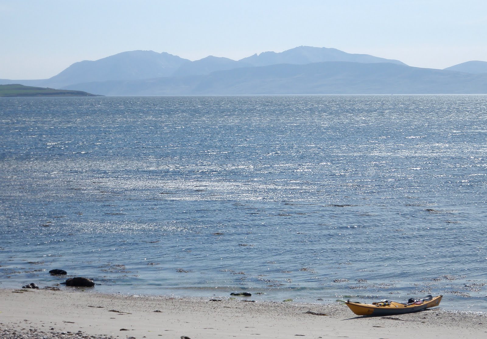
Journey's end at Kildavanan with Arran beyond.  The wind still flattening the water in Ettrick Bay, but as ever it didn't look as imposing from the beach.....

I was picked up at Kildavanan - it helps having relatives on the island!

This is a really good trip with variety and wildlife.  In the more usual westerly airflow it would make sense to start at Colintraive and finish in upper Loch Fyne.  The weather for my trip was a complete contrast to that experienced by Douglas Wilcox and friends on their trip in the same area, this variety of conditions and light is surely one of the attractions of sea kayaking in Scotland.

The distances were 36 kilometers on day 1 and 25 on Day 2; add about 20 kilometers to complete the journey through the Kyles.

Four Ordnance Survey Landranger 1:50,000 maps are required for the trip:

Sheet 56 Loch Lomond & inverary
Sheet 55 Lochgilphead & Loch Awe
Sheet 62 North Kintyre & Tarbert
Sheet 63 Firth of Clyde Area

In upper Loch Fyne HW is +0011 Greenock. 
Tidal stream at the narrows runs at 1Kt Springs, but 2Kts close to the end of An Oitir
Tidal streams in lower Loch fyne are not significant.

Tidal streams enter both the East and West Kyles of Bute on the flood, meeting some way east of the Burnt Islands.  Streams may reach up to 3kts at Springs

Tuesday, 3 May 2011

Wrinkled rocks and furrowed sea at Ardlamont Point


I'd pitched the tent in near darkness on the inner end of a grassy spit with a lagoon behind. After a breezy night I was woken by natures own black and white alarm clocks - Oystercatchers calling as they started their day.  Soon after, they were joined by trilling Sandpipers and my first sound of a Cuckoo for the year.  Clearly it was time to get up!

I was on the water and away by 0730, continuing south then SSE toward the marina at Portavadie.  I could see a huge cloud of dust being blown from the car parks here across the water.  It was going to be a tough day, and as soon as I turned SSE the wind was in my face.


I was able to slog across the more open stretches, then shelter close to the shore in bays with west facing shores.  Here it was very peaceful and quiet.  Early Spring flowers like these Primroses (Primula Vulgaris) have been joined by some later flowering plants - here Red Campion (Silene dioica) making a nice contrast.


Rounding Rubha Preasach (wrinkled point) the first view of the Arran hills opens up.  The wind tearing across the Sound of Bute in the distance was a warning that the shelter of the bay I was in was coming to an end.


The rocks toward Ardlamont Point become increasingly folded and layered.  Tiny inlets of green water are formed where the beds ride up over each other.  I noted several terrific camping spots for future trips.  This rock gave me some shelter to rest, eat and drink before starting the crossing to Bute.  Plans to journey up through the Kyles of bute to the east side of the island were already gone - I would head straight to the west coast around Ettrick Bay.  In good conditions the 4km crossing would take about 45 minutes.  In the F5 gusting F6 now blasting around Ardlamont Point, I anticipated it would take a tad longer!

Monday, 2 May 2011

A Fyne day for a Royal wedding

The day of the Royal wedding of Prince William and Kate Middleton was forecast to be a fine sunny day with a fresh to strong easterly wind - far too good to be sat in front of a television!

I planned a two day paddle down Loch Fyne and across to the Isle of Bute, hopefully going through the Kyles of Bute to the west side of the island.  I knew I'd have shelter from the easterly wind until I got into lower Loch Fyne, then I'd probably be exposed to it.

There's a good launch site in the village of Strachur near the head of Loch Fyne and I set out in very warm weather.  The wind was funnelling down the loch and gave me a good push.


Below Strachur, the lands on the east shore of Fyne are known as Strathlachlan.  It's a pleasant mix of wooded shore with pasture and moorland above.  After about 10 kilometers Kilbride Island is reached; above the shore on a small headland with views up and down the loch is a ruined chapel.  The name "Kilbride" suggests that an early monk may have used this place (the prefix Kil or Cill normally indicates a monks cell).  What is certain is that in the 12th century land and money were granted by the chief of Clan Lachlan to a group of friars in order to establish a chapel here.  As well as the main building, there are traces of other outbuildings visible on the ground.


A few kilometers further on, the ruin of Castle Lachlan occupies a rocky knoll next to a sheltered bay.  There has been a castle of one form or another here since the 12 century, with this building probably dating from the 13th century.  It was the seat of Clan Lachlan (or MacLachlan) who claimed ancestry from Irish princes (a Royal connection!).  The clan received land from Robert I of Scotland in the 12 century and were related to Clan Neill of Barra and Clan Sween - both clans noted sea raiders.


The castle is unusual in that within the square keep wall are linked tenement buildings and vaulted arches.  this was meant as a dwelling as well as being an impressive statement of power.  Today the south facing ivy-grown wall was a suntrap for visitors.


12 kilometers futher down the loch is Otter Ferry.  The name has nothing to do with the aquatic mammal, but derives from An Oitir (the spit), a sand bar which extends half way across the loch from here.  The ferry operated from the 18th century until 1948, and an anti-submarine boom was placed across the loch during World War 2.

The most significant building here now, especially for thirsty sea-kayakers, is the Oystercatcher.  A fine location for a sea kayaking pub, it also has the advantage of serving very fine Fyne ales.  I felt duty bound to drink a toast to the happy couple.....

The afternoon was turning to evening, but I had another couple of hours to go before finding a great camping spot on the shore.  I had great sightings of an Otter and a Fox on this stretch, the fox eading down the shore almost level with me.  At one point he stopped and sat down in a very dog-like manner to watch me pass.  So far I'd been sheltered from the wind, but during the last hour it had been increasingly turning against me and I knew that the following day would be hard.  It was time for an early night.

Tuesday, 26 April 2011

Birds and rocks, Spring on the Moray Firth

After an enforced gap in my paddling and hillwalking of four months due to work, a calm and sunny day seemed too good to miss.


I set out from the little harbour of Sandend, which is situated where a deep channel cuts through the rock.  Just out of shot to the right, a sweeping sandy bay is a popular spot with surfers - not today though in the calm conditions


Heading east across the bay, I meandered out to the West Head, rockhopping along the rugged cliffs.  The West Head has a couple of channels cutting right thorough it.  In the more usual conditions of swell on this coast they make intimidating paddling with surf and amplified swell surging through.  This is the wider of the two, and today was easy.


This is the narrower channel.  I've only ever managed to paddle through this once; even with today's low swell it looked difficult, the powerful surges creating a rise and fall of about two metres.  I backed off again!


Going around the point, soupy conditions showed that an occasional swell was still running.

Spring on the east coast brings seabirds in their tens of thousands. Although quite early in the season, Kittiwakes, Gulls and fulmars are on nests. uillemots, Razorbills and the gorgeous Black Guillemots are in rafts off the cliffs along with Eider and Long-Tailed Ducks. Farther offshore Gannets pass in dazzling white lines from their breeding cliffs near Troup Head. A Kestrel was calling constantly at the gulls passing it's cliff nest site; it's going to be a stressful season for this bird! And, a very special sighting. Heading purposefully east toward Troup Head was a Sea Eagle. I had to double and treble check; I've never seen one on the east coast, perhaps this is one of the birds released in Fife. Fantastic to see, hopefully this will be the start of a repopulation of these great birds.


I stopped for a lunch break in the pleasant harbour of Portsoy.  Peaceful today, the village hosts a Traditional Boat Festival each summer which brings throngs of folk from all over the country and beyond.


Theharbour wall at Portsoy is unusual in that it's built from stones placed vertically.  I don't know of any other harbours in the northeast of Scotland built this way.  The depth is indicated by numbers inscribed on stones - interestingly the numbers change to Roman numerals half way up - perhaps the mason couldn't fit the Roman equivalents for 7, 8 and 9 on the faces of the stones!

A slow paddle took me back to Sandend where the sun was hot and strong.  It's good to be back!

Monday, 11 April 2011

A colourful day on the Dorset cliffs

Whilst I've been at work, I've had a few opportunities to explore the Dorset coast on half day walks.  It's a surprisingly wild coast in parts and very varied.  In superb Spring weather yesterday, the walk along the stretch from Bowleaze to the White Nothe was truly beautiful.  The air was alive with birdsong, and I had my first view this year of a Common Sandpiper - the migrants are arriving in force.

The view to the east was truly exceptional


The chalk cliffs of this part of the coast were dazzlingly white and contrasting superbly with a calm and very blue sea.  This is the view from the headland of White Nothe looking over Bat's Head and Lulworth to the distant Purbeck Hills.  The top of the detached arch of Durdle Door is just visible immediately beyond Bat's Head, which itself has a small arch


Looking down from the cliffs, the water was clear enough to see every detail of the reefs.  I sat in the sun, enjoying the warmth and thinking what a great day it would be for sea kayaking.  As if by magic....


First a double kayak passed, the air so still that I could clearly make out the voices and paddle splashes way below


And then four brightly coloured singles passed, all heading west toward Ringstead..  I lost sight of the lucky paddlers as they passed Ringstead, maybe heading to Weymouth.  They (and I) were treated to a great day, a real hint of the summer to come.

I fairly caught the sun, my face was glowing during the eveening - one more colour to add to the day!

Saturday, 26 March 2011

First Flowers


There are hints of Spring beginning to appear.  Birdsong is increasing, there's a bit of warmth in the sun and plants are reappearing.  A sunny bank by the side of a west coast sea-loch still has the bleached look of winter, but shoots of Woodrush and Yellow flag are everywhere, and there's the occasional splash of brave colour where a Primrose (Primula vulgaris) is in flower.

It's such a welcome sight!

Saturday, 12 March 2011

The road to Assynt

Looking through some pictures, I came across these, taken in February 2006 on a weekend of very fine weather.


Cul Mor is reflected in a hill lochan.  A great hillwalk from Knockan, it can be extended to include Cul Beag, a long but rewarding round of two Corbetts.


The first thrilling view of Suilven (norse: Pillar Mountain), the improbable shape rearing up over the Lochinver road.  Suilven is peculiar in that it looks startlingly different from different directions.