Saturday, 30 April 2016

Full of life at the Place of the Dead


Our paddle along the wonderful NW coast of Jura continued under the pure blue of a Spring morning sky, the wild scenery a constant delight.


Conditions were idyllic and in contrast to the previous evening when we'd had to fight our way clear of the tide in the Corryvreckan strait, out boats seemed to be moving effortlessly through calm, clear water with barely any exertion required.  I think that on this stretch we all fell into a bit of a daydream, but what a location in which to dream......


Mike's call of "eagle!" from behind brought me sharply out of my daydream; the great bird swept along the cliff, landing almost directly above us to examine these strange floating objects.  Huge and impressive birds, a sighting of  a White Tailed Eagle is always a thrill.


Our first goal of the day was Corpach Bay - the name translates as "place of the dead" and indicates that this was one of the places where corpses in transit to the burial islands of Oronsay and Iona were temporarily kept if the weather was too rough for the crossing.  Corpach seems to have been associated with Iona and there's a cave behind the beach where the dead would have been placed while waiting for suitable conditions.


We'd had an early start from Glengarrisdale and it was definetely time for second breakfast!  Our landing was a very easy one on the sandy part of the beach in calm conditions - but this wouldn't be an easy place to land with any swell; there are concelaed boulders and a steep berm of pebbles at the high water mark.


From our seats on clipped turf above the beach we had a super view north to Mull with Ben More very prominent.  Iona was a low smudge on the horizon, the destination for many a final voyage from this beach.  Such sombre thoughts weren't uppermost in our minds on this lovely Spring morning though, the soundtrack to our breakfast was that quintessential sound of Spring, the songs of Skylarks cascading and tumbling from the blue above us.


Surf washed boulders made for interesting patterns on the shore as we made our way back down to the boats......


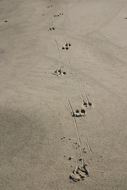
...past the tracks of Red Deer which showed that we weren't the first visitors to Corpach beach that morning.

Corpach may indeed be the "place of the dead", but on a morning like this it seemed to us to be simply full of the joy of life.

Thursday, 28 April 2016

The wild and lonely coast of north west Jura


 We slept well in Glengarrisdale bothy, rising early to a sparkling Spring morning. After breakfast we cleaned out the bothy and laid the firewood ready for the next occupants before saying our goodbyes to Tom and Frances.  Our Iindispensable Kayak Expedition Accessory bags were carried down to the boats - lighter by some food, firewood and a couple of containers of sports recovery drinks each.


 We set out onto a flat calm sea under a cloudless sky of intense blue - the colours of the land fairly zinging in the clear air.


 The northwest of Jura is a wild and lonely coast. Whether on foot or on the water one needs to be self-reliant as well as self-propelled as no paths penetrate the area for a full 25 kilometres of coastline, moor and hill.  Often beset by heavy swell and bad weather, we felt privileged to be able to experience this special place in such benign conditions.


A short distance out from Glengarrisdale we passed the first of several mimetoliths encountered on this side of the island - promptly christened "Iguana Rock" !


 Fifteen kilometres distant, the island of Colonsay lay low on the western horizon.  Our plans had included the possibility of crossing to Colonsay to explore a little of its east coast.  At the fireside planning session the previous evening we'd voted unanimously that both Jura and Colonsay deserved longer exploration than the weather window of around four days we had available - and therefore that we'd stay on the Jura coast and save Colonsay for a future venture rather than paddling out to "tick" the crossing - it was an easy decision to make.


 Headland after headland of wild coastline lay ahead of us awaiting exploration.  The underlying rock of Jura is mainly metamorphic quartzite; in fact it's the largest area of this rock north of the Highland Boundary Fault and shows up on the coast in beaches of bone white pebbles.  A characteristic of quartzite is that it produces poor, peaty soils and rough terrain pretty unsuitable for agriculture.  Only on the east side of the island is the quartzite varied by a narrow strip of schist which breaks down to much more fertile and abundant soil and that's where almost all the population (and the distillery) are.  The prevalence of metamorphic quartzite is part of the reason why there are some 6000 Red Deer and only 200 people on Jura, the eighth largest of the Scottish islands but one of the most sparsely populated.


 Along with there are numerous wild goats and we saw small groups right along the shore and above on seemingly inaccessible cliffs - animals completely at home in their environment.


We paddled at a very relaxed pace, taking time to absorb the view and the situation.  The first of a series of raised beaches came into view, the level of the shore at the end of the last Ice Age.  Since then the land has been rebounding from the release of the ice sheet in a process known as isostatic rebound, we could trace the former high water mark along lengthy sections of the coast.  What a place this was to sea kayak!

Wednesday, 27 April 2016

Shared warmth at Glengarrisdale Bay


Once clear of the Corryvreckan we set off to paddle southwards along the northwest coast of Jura.  The tide on this section of coast doesn't conform to the usual reversing flow, it runs constantly NE'ly so we knew we'd make fairly slow progress.


The northern part of the island is rugged and folded, indented with rocky bays, landing places are mainly marginal and prone to swell.  Our destination for the evening was Glengarrisdale Bay, one of the few sandy bays offering easier landing - with the added advantage of a well maintained MBA bothy for our overnight accommodation.


As we pulled our boats up onto the strand at the end of a 24km paddling day we could see that the bothy door was open and that a tent was pitched outside.  Tents outside a bothy often indicate that the place is busy so we thought we may need to camp after all - not a problem as there's plenty of flat ground for tents.


When we reached the bothy we found that in fact the only folk staying were Tom and Frances who'd pitched their tent outside for sleeping but were using the bothy on a rest day from a backpacking adventure up the west coast of Jura (having previously walked the east coast).  This is a quite remarkable route - there are no paths at all along Jura's west coast and the going is very rough, to say nothing of having to detour around a sea loch which almost bisects the island.  Tom and Frances' adventure put our short 4 day trip in real perspective!  They'd so far been out for over a week and had a couple more days to go - some food left by previous occupants had enabled them to take a rest day and maintain sufficient supplies for the rest of their route.


While Tom and Frances went for a walk up one of the hills at the back of the bothy to watch the sunset and to collect additional firewood, we cooked and ate our evening meal outdoors before turning our attention to things combustible.

We had each brought a Wilcox Ignition Aid (TM) and a quantity of dry firewood inside our boats.  At the bothy were a collection of larger logs and branches, perhaps left by the estate or salvaged as driftwood.  Attempts had been made to saw some of these up, perhaps when they were wet.  Tom and Frances had borrowed our folding "bothy saw" to cut up driftwood on the shore, so we got to work with a bow-saw from the bothy.  When we had reasonable chunks we were able to use a felling axe and a rock "sledgehammer" to produce a satisfying pile of wood for the evening and for the next occupants too; the work involved meant that we'd be twice warmed by the firewood!

Before long we had the fire away and "the lum reeking", a great sight at any bothy.  Our post-dinner dram was, naturally, a Jura whisky - "Superstition"


When Tom and Frances returned they brought driftwood and some peat to leave for the next bothy-dwellers.  We all sat in the main room and enjoyed the warmth of the fire, chatting about how good it was to be here; and reflecting that we were almost certainly the only five people on the whole 40km west coast of Jura. 


We allowed the fire to burn down a little in order to bake sweet potatoes wrapped in foil in the embers.  We found an extra potato for our friends - who had actually been dreaming of baked spuds the previous evening!  Chatting with Tom and Frances gave the additional warmth of our shared love of these special places - and made for a really pleasant evening in front of the fire.

Douglas, Mike and I decided to sleep upstairs in the bothy; the attic space is boarded out and makes for a spacious sleeping area which by the time we retired been warmed by the heat of the chimney breast.

Tuesday, 26 April 2016

Corryvreckan - "a depe horlepoole quhairin if schippis do enter thair is no refuge but death onlie".....

At 1525 we launched from Port nam Furm to make our transit of the Gulf of Corryvreckan, intending to take advantage of the slack water period as the flood tide subsided.

This narrow channel running between the islands of Scarba to the north and Jura to the south has a fearsome reputation - the quote in the title of this post is from a 16th century "rutter" or pilot book compiled by Alexander Lyndsay, the pilot on James Vth's voyage around his kingdom.  In the days of sailing ships the Admiralty Pilot warned against attempting the passage and even today in the age of powerful vessels and GPS, the current Admiralty West Coast of Scotland Pilot states that it is "very violent and dangerous" and that "no vessel should attempt the passage without local knowledge".

The Corryvreckan (speckled cauldron), third largest tidal whirlpool in the world, is only part of the problem.  Huge volumes of water pass through the channel on both flood and ebb tides, on the north-going flood the water pours up the Sound of Jura and is forced through narrow passages to the north and west, the Corryvreckan taking a significant part of the stream.  On the south-going ebb the process is reversed and water is forced through the channel from west to east.

The seabed in the channel approaches and the channel itself is very complex and accelerates the flow of water, producing tidal streams of up to 8 knots (16  kph).  A complicating factor is a pinnacle on the north side of the channel which rises from a 219m deep "hole" to within 29m of the surface, with a very steep face on its eastern side.  On the flood tide particularly, this topography combined with the speed of the flow causes a massive upthrust of water which surges past the pinnacle and sets up an enormous whirlpool with vortices spinning off downstream to the west.  If you then combine this dynamic water with a wind and swell from the western entrance to the channel, the resulting conditions can be truly elemental with standing waves of up to 9 metres and a roar which can be heard up to 20 kilometres away.

As we set out, we met the tour boat "Sea Leopard II" coming eastward from the channel.  As soon as he saw us, the captain throttled right back to minimise his wash - a courtesy we were grateful for; a wash in confused water can produce quite difficult waves.  The video embedded on Craignish Cruises website is an excellent explanation and film of the Corryvreckan - and if you don't fancy kayaking the strait then the Sea Leopard II would be by far the best way to experience the whirlpool and the wildlife of the area.  To get an idea of the power of the tidal stream at Spring tides, this video shows the RNLI lifeboat in the main flow.....

We were very cautious because from Port nam Furm it isn't possible to see what conditions are like in the Gulf itself.  We expected some swell from the west due to strong winds in the preceding days, so it would have been unseamanlike and foolish to have attempted the passage when the flood tide (3 days before Springs) was running strongly.


As we entered the channel and gained a clear view to seaward we were relieved to see quiet conditions and no breaking swell - it appeared that our prospects would be somewhat brighter than "death onlie" !  As if stage-managed, the sunny conditions were replaced with a grey cloud sheet as we entered...


In the narrowest part of the channel the water was swirling and forming gentle hydraulic cushions, but our timing had been good and we passed through easily on slack water.  One factor in our planning of time and tide for this passage was that if we encountered nasty conditions at the west side of the Corryvreckan we could wait a short time for the ebb to build and push us back through the channel to safer water in the Sound of Jura.


However, the timing needed to be calculated accurately - slack water lasts just minutes and the flow picks up very quickly.  By the time we reached the west entrance the east-going flow could already be felt and paddling became a bit more strenuous.


On the Jura side of the western entrance are a couple of small islands and skerries.  We passed inside Eilean Beag (little island) as the ebb began to really get started and had to PLF for a good 15 minutes to escape being drawn back through the Corryvreckan.  For a good five minutes we were paddling at maximum output but making good just over 1kph against the strengthening tide.  To see how strongly this section can run at full flow, the same bit of water is featured from the 9 minute mark in the HebrideanWild video.


After a strenuous pull we won safely clear of the Corryvreckan.......the wild west coast of Jura was now ours to explore.

Monday, 25 April 2016

Time and tide - heading to Jura

My spell of several months working away was finally over. Douglas and I had discussed various trips by email through the preceding couple of weeks - everywhere from the far north to the south west of Scotland - but as ever our planning would be informed by the weather.

A large high pressure system rooted over the UK gave us a great opportunity to explore somewhere exposed and remote, but there was the complication of strong westerly winds in the days before the high pressure calmed things down. After considering various options we settled on an exploration of the west coast of Jura, one of the large islands of the Inner Hebrides.  You'll be able to follow our adventure in "Sea Kayak Stereovision" by reading Douglas' account starting here.

Planning for any trip to Jura is complex.  The island is surrounded on threee sides by water with fast tidal streams, including the notorious Gulf of Corryvreckan to the north.  The only coast with relatively beningn tidal streams is the exposed, wild and uninhabited west side of the island.  All this meant that our usual two texts and a phone call wouldn't suffice at all!  Time and tide would be critical for almost every stage of the journey we intended to undertake.  Our planning remained flexible and as it turned out we altered our plan significantly during the trip.  Our initial plan was for a four day adventure leaving from the Argyll coast and heading anticlockwise around the north of Jura, right down the west coast to Islay and then back to explore the loch which almost bisects Jura before crossing back to Argyll.  We also retained a possible option of heading over to the island of Colonsay should conditions allow it.


Our first time-critical element was a departure from the mainland in sufficient time to allow a transit of the Corryvreckan around slack water.  Douglas, Mike and I met up at Carsaig Bay near Tayvallich at mid-morning to pack the boats and prepare at a measured pace.


And then we were off - another adventure was underway!  Using the light breeze we started straight across the Sound of Jura in order that we didn't get caught in the main stream of the flood tide heading north up the channel - which had the potential to carry us well beyond Jura and would be impossible to paddle against.


The Paps of Jura dominate the view across the Sound - and if our plans were successful we would be on the opposite side of these fine hills two days later.


After a steady 8 km crossing of the channel we made landfall on Jura at a pebble beach to stretch our legs.  We could now afford to take our time as we had a couple of hours to wait for slack water in the Corryvreckan


Heading north along the coast we passed the farmhouse of Barnhill. In 1946-47 an author named Eric Blair lived here while writing a novel, partly to improve his fragile health.  On 19th August 1947 Blair led a boating trip during which their boat was swept into the Corryvreckan and overturned.  Fortunately all of the party managed to scramble ashore to a rock where they were later picked up by a passing fishing boat.  Blair is better known by his nom de plume, George Orwell, and had he perished in the Corryvreckan the modern literary classic "1984" would have been lost with him.


The flood tide ran north at full pelt and with a breeze behind us we fairly belted along at 14km/h.


In order to retain control over when we entered the Gulf of Corryvreckan it was necessary to break out of the main stream and into slower moving water close inshore where boils and swirls marked the surface.


It was quieter here and we drifted along for a while as the island of Scarba grew closer, marking the left turn into the Corryvreckan strait. The nearest headland is the point where we needed to get off the water to wait for the strength of the flood to subside prior to attempting the Corryvreckan. 


The tiny pebble beach at Port nam Furm provided an easy landing and we set up our lunch things in the sun to watch the changing face of the sea as the tidal movement continued running into the channel between Jura and Scarba.  Very appropriately, the name Port nam Furm translates as Port of the Seat.  Clearly we were the latest in a long line of mariners to sit here and wait for the right conditions before entering the Corryvreckan.  An alternative translation might be Port of the Last Chance!

While we drank coffee in the pleasant sunshine an Otter fished across the bay in front of us, coming really quite close to inspect the boats on the shore.  Gradually the speed of the flood reduced towards slack water at a little after 1600.  By 1525 we were ready to get back on the water to take advantage.....

Friday, 8 April 2016

The Roseland Peninsula - St Just to St Mawes


Continuing my walk exploring the Roseland peninsula, I arrived in the village of Portscatho in a particularly heavy rain shower.  As I headed inland from the village the rain passed and a burst of sunlight brought out the colours of land, sea and sky to great effect.  My plan was to cross the peninsula using country lanes and farm tracks in order to walk back to St Mawes - the ferry timetable dictated that my pace would need to be fairly brisk....


But having arrived at St Just in Roseland, I made time to slow down and visit the parish church. Situated on a tidal creek in a very sheltered spot, the church is at the base of a steep bank, and the churchyard is one of the most remarkable anywhere.  Part cemetery, part semi-tropical garden, it's an incredibly beautiful, unique and when I visited, peaceful spot.  the church is however, one of the most photographed in Cornwall and must get very busy in the summer.

There was plenty of evidence of the early spring here - the view down to the church tower was framed by the flowers of a large Magnolia - in almost full flower before the end of March.


The church of St Just in Roseland dates from the 13th century and is built on the site of a Celtic chapel and was served by Celtic clergy from nearby Lanzeague for the first 400 years before being taken into the Saxon, bishop led, church.  Cornwall and the French region of Brittany have a shared Celtic heritage which is fiercely preserved with distinct language and customs.  A 19th century vicar planted many of the exotic trees and plants which today make this a very special and unique place.  Along the path edges there are many granite blocks inscribed with biblical verses, at this time of year surrounded by masses of Primroses.


Having lingered at the church I pressed on down the western edge of the Roseland peninsula.  A path goes through farmland just above the shore here but after a spell of wet weather it was incredibly muddy and I ended up abandoning the path to walk and clamber along the rocky shoreline itself - which proved a bit more strenuous but a lot less messy!  I arrived at St Mawes in good time, and in a burst of warm sunshine.  As I'd walked close to 25 km and had a half hour to spare before the last ferry, I felt that some refreshment would be in order, and so......


....repaired to a suitable purveyor of refreshments and sat in the sun to enjoy.....


...a frothing Sports Recovery Drink......


The ferry "Duchess of Cornwall" arrived right on time and soon I was crossing back to Falmouth, reflecting on a great day's walking.  If the Place ferry is running, this is a walk well worth the effort - starting at either Falmouth and using two ferries, or at St Mawes using just the Place ferry.  Shorter loops can be walked too, based on either St Mawes or Place.

My thanks to Sam, skipper of the "Duchess of Cornwall" for going out of his way to drop me at Place on a day when the small ferry wasn't running.

Tuesday, 5 April 2016

The Roseland peninsula - a Place apart


Whilst working in Cornwall I've managed to do some coastal walking based around the town of Falmouth.  One stretch of coast I'd particularly wanted to explore was the Roseland peninsula, but not having use of a car this involves two ferries.  A couple of attempts to reach the area were unsuccessful due to winter ferry timetable restrictions or windy weather preventing the smaller ferry running.

On a bright and breezy day the plan came together.  I caught the ferry from Falmouth to the pretty village of St Mawes, and although the smaller onward ferry wasn't running, the skipper of the "Duchess of Falmouth" kindly dropped me at the landing point on the Roseland - a place called Place.  From near Place, theere's a lovely view back to the neat white houses of St Mawes.


The coastal path passes behind Place House, through a churchyard containing a mediaeval stone coffin......


...before crossing farmland to the shoreline with a view to the lighthouse at St Anthony's Head.  Built in 1835, this light marks the eastern entrance to the large natural harbour of Falmouth - Carrick Roads.  It was originally lit by Argand lamps, then by pressurised vapour (the former paraffin store is near to the path) before being converted to electricity in 1954.  The light flashes white once every 15 seconds, is visible for 22 miles, and contains a red sector to warn shipping of the Manacles rocks.  As there are no longer any lightkeepers, part of the building can be rented as holiday accommodation.


Also protecting the entrance to Carrick Roads, which is one of the largest natural harbours in the world, are the remains of these gun emplacements - a view indicator sited where the guns would once have been.


The coast path from St Anthony's Head to Portscatho is a pure delight; a path winding along the cliffs above a wild and in most places inaccessible shoreline.  The weather on my walk alternated between bright sunshine and intense, lancing showers of hail and rain - it suited the scene perfectly.


 Conditions have been so mild in Cornwall through the winter of 2015-16 that it's hardly been a winter at all.  Daffodils flowered in late January, and on the last weekend of March the Primroses were well in bloom.  Quite a contrast to home in Aberdeenshire some 700 miles north!


Towan Beach was sheltered from the wind and pleasantly warm inbetween the showers; a couple of hardy souls were even taking a swim.  It was tempting to linger, but I had the ferry timetable firmly in my mind - I needed to be back at St Mawes to catch the last ferry to Falmouth, departing late afternoon, so reluctantly pressed on.