I'm lucky to have Bennachie as a neighbour. One of the most prominent hills in the north east of Scotland, a glimpse of the distinctive outline of the Mither Tap (Mother Top) means "home" to generations of Aberdeenshire folk. Bennachie inspires a real fondness in people and there's even a dedicated band of volunteers known as the Bailies of Bennachie who look after the hill and its environs. I climb it regularly by a variety of routes, but there was one which I hadn't done.
Lorna, Allan and I met up on a bright late summer day to do one of the longest routes on Bennachie, a traverse from one end to the other of what's essentially a long ridge with a number of "tops". They live closer to the hill than me and have a clear view of it from their house - a very desirable feature in any property I feel!
We pre-positioned a car at the end of our intended walk and drove back west to the top of a feature known as the "Lord's Throat", a wooded valley carrying a minor road. A rough track leads to a sand quarry and after a bit of scratching about we climbed above the quarry and onto the open hill above. a view opens up straight away to the furthest tops of Bennachie above the valley of the River Don.
The heathers were all in full bloom, the colours stunning. This is the larger flowered Bell Heather (Erica cinerea).....
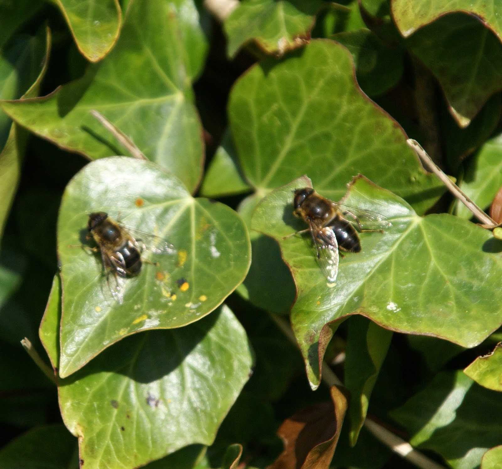
...and this is the more ubiquitous Ling heather (Calluna vulgaris). As we walked our boots raised clouds of honey-scented pollen and one of the dominant sounds was that of the bees collecting pollen - we saw several species on this part of the hill.
This is a corner of the hill I hadn't previously walked and I was intrigued by a line of very old and long-disused shooting butts arranged in a line upslope. Drystone built, the may have been turfed on top when in use and each had an offset entrance for the "gun". Interestingly, almost every one harboured a Rowan tree. Rowan (Sorbus aucuparia) seeds germinate in an interesting way; if you plant them they just won't grow. The seeds are contained in a bright red berry which are irresistible to many species of birds. the berry and seed must first pass through the gut of a bird in order to germinate; and of course will benefit from having a blob of guano fertiliser to boost its chances. The berries are irresistible to some humans too - they make a superb jelly to accompany meats and cheeses!
Rowans are one of the most common trees in Scotland, and are the tree which reaches higher altitudes than any other species here - up to 870m/2850ft in a few places. There's a rich folklore surrounding the tree; it's associated with protection and was commonly planted at the gable end of a house to afford protection from witchcraft in particular. Rowans rarely live longer than 150 years so it's possible to guess the dates of some ruins by the Rowans near to them. Here, in a lovely piece of symmetry, the works of man provide protection for the Rowan - the seeds dropped by a bird have fallen into the grouse butts and the seedlings have grown within the circular embrace of the wall, protected from weather and from browsing animals until well established.
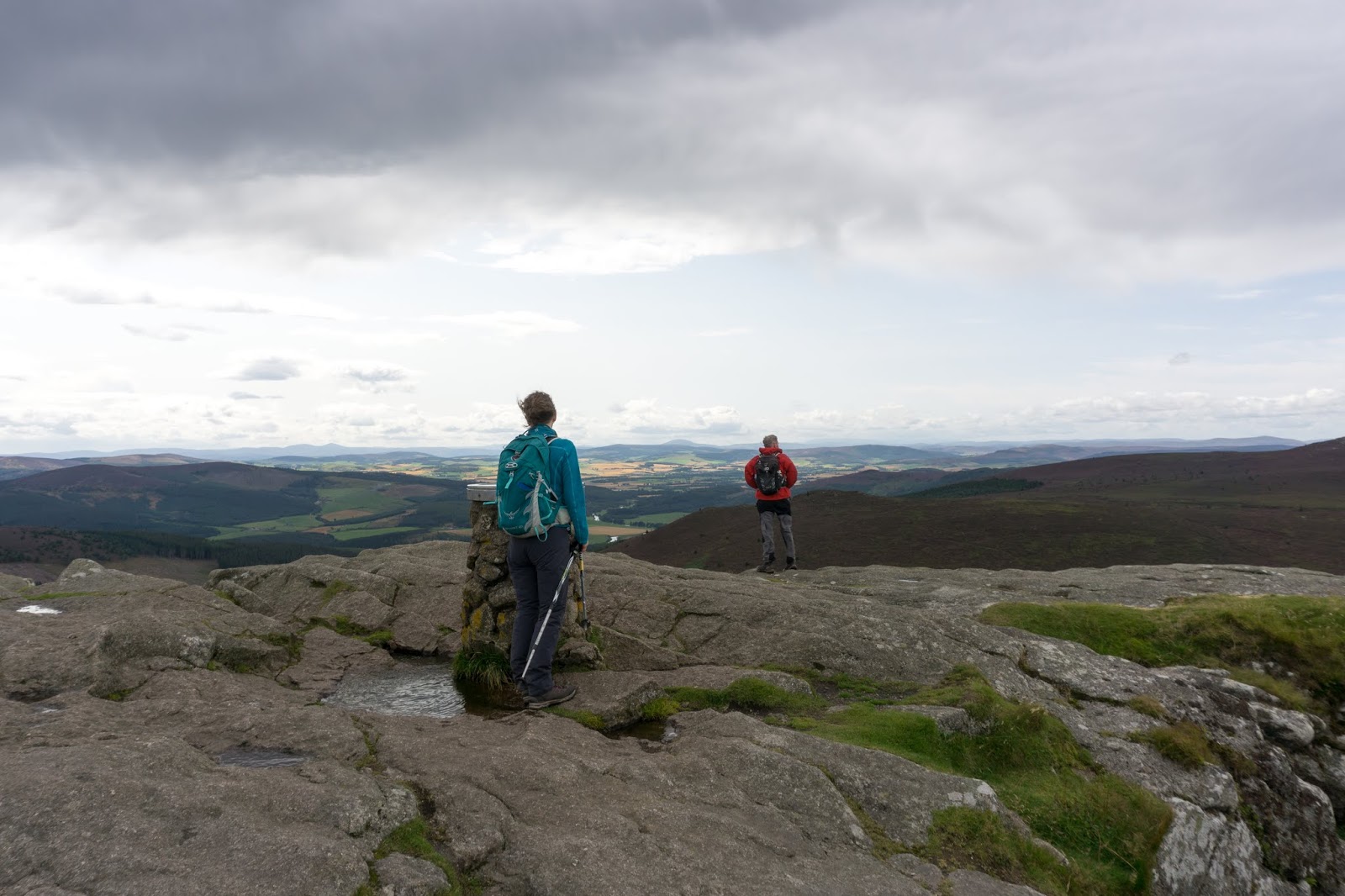
From near the summit of the first "top", Black Hill, there's a wide view over the Aberdeenshire countryside. Due to its relative isolation from surrounding high ground such good views are a feature of the whole of Bennachie.
From Black Hill the ridge proper swings into an east-west orientation and as we continued west the views just kept coming. We took a slight detour to the "top" of Hermit Seat (who was the hermit I wonder and what was his story?) and past Hummel Craig. A Hummel is a stag with no antlers and Craig is a derivation of Crag. From the next "top" of Watch Craig we looked over the valley of the River Don to Pitfichie Hill and Cairn William. Allan and Lorna were just able to see their house from this point!
Once up on the higher ground the paths on Bennachie are really good going and distance just reels away. In quicker time than we'd anticipated we found ourselves on the rocky tor of Oxen Craig. At a modest 528m/1736ft this is the highest point of Bennachie but probably visited by only a small percentage of the folk who climb "Bennachie". Behind us rain showers were strafing the land further west...it seemed we'd probably get wet before the day was done.
A view indicator plaque identifies some of the hills and key features to be seen from Oxen Craig, including some at considerable distance. The view ranges from the city of Aberdeen in the east, round to the hills of Angus in the south, to the Cairngorm giants almost 70 kilometres away and round north to Peterhead and the Buchan coast - an enormous sweep of the northeast of Scotland.
We sat out a shower below Oxen Craig and once it had passed headed slightly off the main line of the ridge to another "top", Craig Shannoch.
From Craig Shannoch there's a good view across to the main attraction of any walk on Bennachie - the Mither Tap. In fact the Mither Tap is Bennachie for most folk; the name of the whole hill is a derivation of Beinn a' Chioch (hill of the breast) and it's the Mither tap which is the most visible, most prominent feature. Across a huge swathe of Aberdeenshire you can look for it - the eye instinctively drawn to a familiar outline. Bennachie, always Bennachie - it's what inspires such affection for the hill. The Tap is a granite plug from the heart of a long ago eroded volcano and has considerable steep drops on three sides. I'd guess that only about one in a hundred people who climb the Mither tap go on to walk to the "real" summit of Oxen Craig - such is the draw of the Tap.
We climbed to the summit, almost able to lean on a tearing westerly wind. We'd traversed top to top to reach the Tap, a fitting end to the high ground of Bennachie.
This place has a long history of use. Being so prominent prompted the building a hillfort here. Constructed during the Iron age and possibly occupied as early as 1000BC, it seems to have been developed for a long period and may have been the site of the battle of Mons Graupius (which gave its name to the Grampian region and mountain range) where the Picts were heavily defeated by a Roman army. The aerial pictures on the Canmore site show the extent of the ruins.
The curving entrance to the upper fort is particularly well preserved - here you can really walk through ancient history.
The descent from the Mither Tap to the Bennachie Centre is knee-jarring, steep and in places rough. Although the shortest route in terms of time and distance I've always thought this the least attractive way to climb the Mither tap. There are a number of ways to reach the Tap, as shown on this downloadable map, or you could always do our longer route of around 10kms! We'd enjoyed a superb day doing this route; it's one all three of us will repeat.
Showing posts with label Iron age. Show all posts
Saturday, 14 September 2019
Monday, 11 June 2018
Blown away by Dun Carloway
From Calanais we headed north along the road which hugs the coast of Lewis to a visit a place which I'd been really looking forward to, possibly more so than the stones we'd just seen.
Dun Charlabhaigh (Dun Carloway) is visible from a long way, and was meant to be seen. An iconic outline on a prominent ridge line, even in a partially ruined state it's a striking sight.
Dun Carloway is a broch; a type of fortified residence unique to the north of Scotland, the Northern Isles and Western Isles. A "Broch" can be described as a tapered round tower construction with more than one internal floor level, and the walls are usually galleried internally.
Built around 100BC, Dun Carloway was constructed at a time when brochs were beginning to be replaced by buildings which required less in the way of resources, particularly timber. It may have been in use as late as 1000AD, which is quite late in comparison with other brochs.
Even in a partially ruined state you can clearly see the two walls with galleries in between. The ruin stands nine metres tall at its highest point and is likely to have been somewhat higher. It would have been had a conical timber roof and timber floors at each level - a significant use of what's a scarce resource on Lewis. Much of the stone from the side which is easier to access has been re-purposed into constructing nearby blackhouses in the past, before the site became one of the first to be taken into national protection under Historic Scotland.
The quality of construction is astonishingly high. No mortar was used, the walls are drystone built with hardly a gap - the building of a concentric, tapering tower of stone in this way must have required skill and vision; and must have been commissioned by a person of significant power.
The stairways between floor levels spiral up inside the walls themselves and are still in remarkably good condition. You have to remind yourself that the brochs date from the Iron Age, but the folk who built this were far from primitive or uneducated. Given that Dun Carloway has stood here for over 2000 years, the fact that internal stairways are intact and usable is nothing short of astonishing; how many modern structures will last that long?
The graceful taper of the walls is carried through internally in the galleries which run around each level. It's likely that livestock could be housed at the ground level with human occupants living above. Brochs are believed to be part defensive refuges and part impressive statements of power and control - several were probably used as refuges from Norse raiders well after they had ceased to be permanently occupied.
Supporting stone slabs were used higher in the structure to strengthen the whole - the more one explores the more the skill and vision of the broch builders becomes evident.
Dun Carloway is looked after by Urras nan Tursachan (Standing Stones Trust) who also look after the stones at Calanais and there's a small visitor centre below the hill which is built to echo the broch itself and is partially underground. Access to the broch is free and you can explore the inside by going through a small gate at the ground level entrance. We were blown away by Dun Carloway
We were blown away by Dun Carloway. In contrast to Calanais there was just two other people around and we were able to glimpse the power, symbolism, the setting of the broch and the craft of its builders. If you visit Lewis, don't miss Dun Carloway!
Sunday, 31 January 2016
Rhynie Symbol Stones
Below the slopes of Tap o' Noth and its summit hillfort lies the village of Rhynie. A quiet and unassuming place, archaeologists believe that at one time Rhynie was a major centre of Pictish power. A glance at the map shows the amount of standing stones and stone circles in the surrounding area, most of which pre-date the Picts, but in 2011 a dig near to the spot where the "Rhynie Man" was found revealed the traces of a substantial fortified settlement. Some of the artefacts recovered were of Roman origin and alongside other research has led to the suggestion that Rhynie was a royal Pictish site.
The Picts have proved elusive for historians; the word most often used when referring to them is "enigmatic". Believed to have been both ethnically and linguistically a Celtic people, they controlled much of the north and east of what is now Scotland for at least 600 years. Despite this prominence, comparatively little is known about them. They left no chronicles or written records and much of what is known of them comes from Roman, Gaelic and Norse sources; peoples they were in conflict with. The Pictish language remains only in echoes down the centuries, in personal names such as Kenneth and Alpin, and in identifiably Pictish place name roots such as "Pit" or "Peth" (as in Pitmedden and Perth), "Aber" (as in Aberdeen) and "Lhan" (as in Lhanbryde).
The most tangible remains aside from fortified sites such as Tap o' Noth and Burghead are undoubtedly the several hundred Symbol Stones discovered across what was once Pictland. Carved with great skill and artistry, most feature a range of uniquely Pictish motifs, often abstract or animistic and sometimes with representations of domestic objects. "Enigmatic" to the modern mind, the fact that the symbols occur on stones across the whole of Pictland from Shetland to the Forth implies that they would have been understood by all Picts. A great resource for discovering more about the stones themselves and the Picts as a people is Historic Scotland's "Pictish Stones" website.
Rhynie has a good collection of symbol stones (aside from the Rhynie Man which, incongrously, is located in Aberdeen city council's HQ). There are three stones in a shelter near to the present day churchyard, with a fourth in a nearby field.
The light wasn't so good for photography when I visited on a grey November afternoon. This, the largest stone, is 1.3 metres tall and carved with a "beast" possibly representing a seal or an otter combined with two typically Pictish abstract symbols- the double disc and Z-rod and a mirror and comb.
An information board nearby has clear representations of the carvings; the one in my photograph is at the lower left.
The fact that the meanings behind the symbols are uncertain adds to the experience of visiting the stones; I find Pictish sites fascinating and hope to explore more in the coming months.
Thursday, 28 January 2016
Tap o' Noth hillfort
The initial and enduring impression as one enters the Tap o'Noth hill fort is the sheer scale of the site. The walls enclose an area approximately 100 by 30 metres, making the site around the size of a football pitch. The aerial view on "Canmore", the digital archive of the Royal Commission on the Ancient and Historic Sites of Scotland can be used as our guide around this impressive place.
Although tumbled, enough remains of the walls to gain an insight into what a mighty fortress this would have been, the tumbled remains of the walls are 6 metres wide and 3 meres high The organisation of labour to build and to occupy Tap o'Noth must indicate an advanced people with a structured society and the means to both construct sites like this and sustain themselves at the same time. Archaeological finds here include an axe head dated around 2000BC-800BC and a piece of bronze horse harness dating to around the 1st-3rd century AD. This would indicate that the site was probably in use from the Bronze Age and continued through to the Iron Age Picts, perhaps starting out as a small fort before being greatly expanded. The word "Noth" is thought to have a Pictish origin and possibly has the meaning of "looking" or "seeing" - very appropriate given the wide ranging views from the summit.
The fort site has a stone lined cistern well, clearly visible on the aerial view as a dark depression near the southern end of the enclosure.
Parts of the wall have been vitrified by intense and prolonged heat, these vitrified sections are mostly concentrated at the north western end wall.
Debate continues amongst experts as to what vitrification represents, destruction or a deliberate strengthening of the walls. There's some more about vitrified hillforts here, and as I visit more vitrified forts it seems to me to be logical that this represents a deliberate construction technique rather than a destructive one.
But the fort itself is just the crowning glory. Lower down (pretty much at the divide between the grass and heather in this image) there was another stone rampart running right around the hill. Remains of over 100 house platforms have been recorded in this area, with a definite clustering on the northern and northeastern slopes, sheltered from the prevailing wind and weather by the hill and the fort.
The line of the lower rampart can be seen in this image. The whole site is a staggering 21 hectares in area; this is no mere defensive bolt-hole or even a status symbol built by an individual - it looks and feels more like a major centre of power; which is what it is believed to have been.
From the northern slopes of the hill a series of terraces exists in places, and occasionally the possible outline of a building. From here the fort wall looks very impressive - how much more so must it have looked when in use?
The effort involved in the building of such walls must have been enormous. It would be a mistake to think that these Iron Age people were in most senses of the word "primitive". Named "Picti" (painted people - probably deriving from the habit of tattooing) when the Romans encountered them in the late 200's AD the Picts were already a force to be reckoned with. A sophisticated and organised society who farmed, kept livestock, indulged in art and sculpture and were fearsome warriors, they dominated northern and eastern Scotland until around 900 AD when the Picts were defeated and absorbed by their Gaelic Scots neighbours.
As I stood in a raw wind at the wall of Tap o' Noth, my thoughts of the warriors who would once have peopled this place were interrupted by a flat roar......
....the signature noise of a modern warrior class - the crew of a Tornado fighter-bomber streaking past in a hard turn.
Tuesday, 19 January 2016
A significant view from the Tap o'Noth
One of the most distinctive hills in the north east of Scotland, Tap o' Noth with its sawn-off cone of a summit lying at the end of a ridge is one of the familiar landmarks of Aberdeenshire. On a walk along the Correen Hills I realised that it had been more than a year since I'd climbed it despite the hill being barely fifteen minutes drive from home.
A couple of days later a dry-ish day and a few spare hours gave me the chance to revisit. I started from the tiny car park below the highest point of the hill from where a straightforward ascent can be made. The route climbs on a track through farmland before contouring out on a level grassy area with the summit cone straight ahead.
The village of Rhynie seems very close from just below the summit area. The village is mainly known for the Rhynie Chert, an early Devonian sedimentary rock deposit aged about 410 million years which contains the earliest known insect fossil, and a strong Pictish connection - of which more shortly....
To the south west there's a long view across to the Buck o' the Cabrach , itself a noted viewpoint lying between Strathdon and Glenfiddich with grandstand views to the Cairngorms.
On the subject of grandstand views, the extent of the view from Tap o'Noth is shown on an information board just below the summit area. Each circle is a 5 kilometre extension with the outer, 50 kilometre ring showing the potential view on clear days. From the North Sea at the city of Aberdeen to the Moray Firth, south to the Angus Hills and west to the high Cairngorms, it's a marvellous panorama from a hill which is just 563 metres/1847 feet high.
Probably the most significant elements of the view are direct sight lines to the Pictish fort at Burghead on the Moray Firth, to the hillfort summit of Bennachie and below to Rhynie itself.
Significant because the entire summit area of Tap o'Noth consists of a huge hillfort; the second highest in Scotland and one of the largest at 21 hectares in area. The best angle from which to get a sense of the scale and extent of the place is from above, as in this image from the Canmore archive.
I first climbed Tap o'Noth when we moved to Aberdeenshire some 15 years ago - I was blown away by the fort then and every time I return it has the same effect - let me show you around......
Saturday, 14 November 2015
Solway sojourn - a southern symmetrical structure
We got back on the water after visiting the beach and folly at Knockbrex and passed another castellated building; this time a water tower. The next point of interest on our journey would continue the castellated theme......
...but with a somewhat older vintage. Marked on the map as a Dun (fort), the ruin at Castle Haven is a remarkable structure. We entered the site via a doorway through a double wall and climbed up to get a better view of this astonishingly large fort.
The site is roughly D-shaped, utilising the line of a low cliff a the straight portion and has a symmetrical double wall right around the perimeter - as clearly seen on the Canmore website aerial image. Dated as early Iron Age, the site was partly reconstructed by James Brown (the owner of Knockbrex House). The reconstruction may have altered the site somewhat - the galleried walls put Castle Haven very close to being a broch, though these are usually found in the north of Scotland and the Northern Isles. The other slight difference from a true broch is that Castle Haven doesn't have an inter-mural stairway.
Ivy is now beginning to overrun the ruins, but it's a very impressive site indeed. The predominant sound within the walled area was the low hum of tens of thousands of bees feeding on the nectar from the ivy flowers - the walls themselves were buzzing.
If Castle Haven is a broch (and it certainly "feels" right); it's the most southerly broch in existence. One thing is certain: Broch or Dun - Castle Haven is a really great place to explore.
Back on the water, and another double wall appeared - the only reconstuction here has been by the force of the sea.....
Friday, 1 August 2014
Colours and caves - Deil's Heid to Auchmithie
After passing the sea stack of the Deil's Heid we entered Carlingheugh Bay where the cliffs become a little lower. A series of dry caves lie above the shore, again these would have been sea caves prior to the isostatic rebound effect as the weight of ice sheets unloaded. Much of Scotland is still rising as the rebound continues at a slow rate, while the southern half of Britain continues to sink at a corresponding rate. We were about to find a cave which is most definitely at sea level though....
The entrance is very obvious, a large square with undercut strata heading back into the gloom.....
...but once inside the space opens up into a large cavern. Some of the rock strata have been prised away by the explosive hydraulic pressure of big swells and have formed a flat ceiling. This view is looking into the cave; the light source behind Joan is from Gaylet Pot, a collapsed section of roof forming a "gloup" 140 metres into the cave.
The mechanics of its formation are really remarkable; the hydraulic pressure which prised away the strata to form the cave would have forced air along one of the fault lines of the Lower Devonian sandstone, compressing still further until it found a weakness where the repeated and concentrated compressive force was able to shatter the rock above, collapsing the roof and forming the gloup. The forces involved must be truly enormous and we could only imagine what this place must be like in an easterly storm.
Today was very calm and the only thing streaming thorough the cave entrance was the late morning sunshine. Duncan was able to land at a boulder beach in the gloup itself to get a further perspective on the feature which emerges in the middle of a farmer's field! After spending some time exploring the extent of the cave we headed back towards the light.
There's an angle from which the whole length of the cave can be seen, though not the extent of the interior. Duncan and Joan can just be made out at the gloup end, giving scale to the place.
If you kayak this section of the Angus coastline on a calm day, Gaylet Pot is a real "must do"!
The next point of interest on this remarkable paddle is Lud Castle, an Iron Age promontory fort site. The site would have been defended by fortifying the narrow neck of land leading out to the headland; it would have mad a great vantage point but appears to have no natural source of water.
Since setting out from Arbroath in the morning, the 6 linear kilometres we'd paddled had taken well over two and a half hours such is the constant interest along this stunningly colourful and featured coast. We must have added half as much distance again in exploring the various geos, caves and channels around the cliffs though! We put some extra energy into the short distance from Lud Castle to Auchmithie in order to land for coffee and first luncheon on the beach adjacent to the harbour.
The harbour itself is delapidated, almost ruinous, but was once a thriving fishing harbour. At lower states of tide the easier landings are on the beach as the harbour bottom has some rocky obstructions. Auchmithie is the home of the "Arbroath Smokie", a local delicacy. Haddock are cleaned then dried for a period before being split and tied by the tail over a slow burning fire of beech and oak (usually in a barrel lined with slate) and covered with hessian. After smoking for 30-40 minutes the fish are cured and ready to eat hot or cold. The result incredibly tasty and very healthy too - a real treat. Unfortunately we didn't have smokies with us, maybe next time it would be fun to bring one back to Aucmithie by sea.....
Subscribe to:
Posts (Atom)


