Showing posts with label Morvern. Show all posts

Monday, 22 May 2017

A Cuil view


The cool northwesterly breeze dropped overnight but the sparkling sunshine of the previous day was replaced by an overcast and murky morning.  The long view up Loch Linnhe from our camp with snow capped Ben Nevis looks cold, but in fact it was a reasonably mild morning.


We decided to paddle straight across the loch before any breeze might start up and create the sort of choppy conditions we'd enjoyed the previous evening.  Landfall of the Morvern shore was made near the Glensanda superquarry, which as ever comes a a jarring intrusion into the loch scenery.
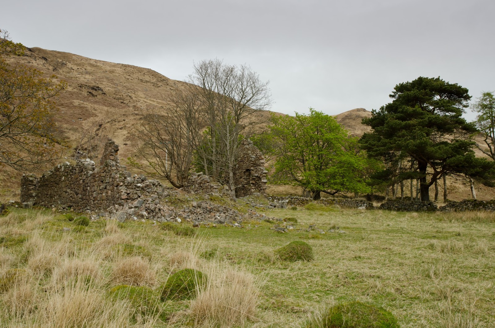


A few kilometres further on we stopped to take a walk around Arigh Shamraidh (the summer shieling).  Visible from across the loch as a green patch lined by trees, there are five ruined buildings and a field system here, the ruins probably date to the early 18th century but earlier maps how a permanent settlement of similar size.


Further along again we passed Camasnacroise (Bay of the cross) with its neatly painted white houses and church on the shore of Loch a' Coire. The church-related names include the hill which towers over the shore - Beinn na Cille (hill of the (monks) cell) In 1890 the village is recorded as having a church, school, shop and smiddy.  The village is quite remote by modern standards, and connected by tiny single track roads.


We enjoyed paddling the wild shore north of Camasnacroise, moving slowly and absorbing the atmosphere of the place.  A couple of potential camping spots came and went before we found a place on a level grassy platform above the shore.  The effort of carrying all our stuff up a steep 20 metre slope was rewarded with a view across Loch Linnhe to Cuil, from where we'd set out.

We could easily have crossed back and ended the trip without camping, but elected to spend another night out and have a short paddle the following morning.


We spent a pleasant evening enjoying the views from our camp, though the morning turned out damp with some drizzle and a thick mist.  I took some bearings and set up a route on my GPS as we packed the boats, as well as putting the VHF radios to "scan" in order to pick up any traffic from vessels moving on the loch which we'd not be able to see.


After travelling up the shore a little way we struck out across Loch Linnhe towards Cuil just as the drizzle stopped and the mist began to break into banks of low cloud.  With such damp, low-light conditions and little wind, we were thankful that the midges hadn't got going by this time in April!


All too soon we were back at Cuil in a rapidly improving morning with a fresh breeze dispersing the last of the cloud. 


 Our two night trip had been relatively short in distance at just over 50Km, but had been really relaxing as we'd deliberately kept our plans to the minimum and just gone with the flow.  It had also been a useful shake-out of our kayak camping kit, which had shown up a couple of deficiencies and necessary tweaks before a longer trip.

Friday, 19 May 2017

Cuil camping

This the first of two catch-up posts from a camping trip Allan and I made on Loch Linnhe in the second half of April.  The plan was for a relaxed circuit and a couple of nights wild camping; for both of us it was the first overnight trip of the year due to work or health reasons.  A bigger trip was in the planning so this would also be a good shake-out of camping kit.


Our starting point was Cuil Bay on the eastern shore of Loch Linnhe, where a couple of cars can be parked by the side of the minor road above the shore - taking care to leave access for farm vehicles.  Cuil translates as either "wing" or "back", both of which would be good descriptions for the shape of the bay.

The weather looked good with sunshine and cloud dappling the long view down the loch towards the distant Mull hills.


We paddled south down the loch in perfect conditions, enjoying the reflections of the Morvern hills on the mirror calm water.  To our left the main A828 road follows the shore for several kilometres and there was some traffic noise, but this soon fades when the road turns inland a little.


We took luncheon on a tiny pebble beach at the north tip of Shuna (the northerly of two islands with the same name in this area, the other being in the Firth of Lorn).  The sunlight was picking out the colours of the pebbles below the water beautifully - it really was a very relaxing spot.  Looking over the loch to Morvern, I recalled one of our trips from the previous year when we'd paddled around Movern in late summer warmth.  Loch Linnhe seems to be overlooked a bit by sea kayakers, but it does have the potential for good trips.


After paddling around the outside of Shuna, our next stop was at the ferry jetty on Lismore.  There's a toilet and water from a tap at the ferry waiting room here, handy on longer trips.  We now had a decision to make....our plan was very flexible and we'd not planned in any more detail than a starting point and a basic direction down the loch.  From the jetty we could paddle down either side of the island of Lismore (Lios Mor - the big garden, so named for the fertility of the island which is on limestone).


We chose to go down the outside, west, side of the island as it has plenty of interest and a few more camping options.  Within 30 minutes of setting out, a stiff NW'ly breeze blew up and made things quite bouncy - it seemed we'd made the wrong choice!

A considerable chop built up as we passed beneath the ruin of Castle Coeffin.  Built in the 13th century by the MacDougalls of Lorn, the castle passed into ownership of Clan Stewart through marriage and eventually to Clan Campbell.


We were glad of the opportunity to tuck into the bay below the castle for a breather out of the wind.  This bay must have been a factor in the siting of the castle as the MacDougalls were a clan of sea raiders, the beach must have been a perfect base for operating the highland version of a longship - the Birlinn.


The bay also contains the well-preserved remains of a medieval fish trap.  The fish were held back as the tide dropped and could be caught easily in the confines of the trap. 

We considered making our first camp on the cropped turf below the castle, but a reasonably polite notice asks that folk don't camp here as it's close to the croft house and is grazed occasionally by horses.  We had a quick look at the map and decided to backtrack on our route a bit to a spot we'd noticed earlier.


It was a fairly stiff paddle back up against a strengthening wind to reach the spot we had in mind, but it was worthwhile as it was a good place to camp with a little shelter from what had become a cold NW'ly wind - a "Cuil" breeze in fact!


After dinner we managed to find a spot for a campfire below the high water line and enjoyed a dram or two to mark the first kayak camp of the year.

Monday, 7 November 2016

Carrying on to the end around Morvern


We woke to a bright morning at our camp on the shore of Loch Sunart, unfortunately so did the midges!  A welcome breeze started up as we ate breakfast which was just enough to keep them away.


We were soon on the water and heading into the enclosed Loch na Droma Buidhe (also known as Loch Drumbuie and meaning Loch of the yellow ridge). The mainland shore of this loch had been one possible camp site, but we were pretty sure that the loch would be busy with yachts as it's a popular and very sheltered anchorage.  There were six yachts at anchor immediately off the spot we'd identified, and anyway we'd have missed out on the superb sunset as the view from the loch is obscured by the high ground on Oronsay.


The east end of Loch na Droma Buidhe connects with Loch Sunart by a narrow channel which dries out to leave Oronsay connected to the Morvern shore.  We knew that we'd have a bit of a portage to move the boats across the gap, but felt that this would be a bit quicker than paddling around the outside of Oronsay against a stiff breeze.

The portage was a bit longer than we'd have liked at around 200 metres but having chosen this route we decided to just carry on and carry the boats over.  The yellow colour of the exposed weed here led us to speculate whether this might be the source of the loch's name?


Back on the water and we had a stiff paddle around the south end of Carna against the ebb stream pouring out of Loch Teacuis.  The flow here can be very strong but we arrived near the end of the ebb and were able to eddy-hop around the south of Carna then enjoy a push out of Caol Charna (narrows (kyle) of Carna).  Although we'd been going less than two hours, a stop for second breakfast was unanimously carried - the exertions of portaging and paddling had rekindled appetites!


Back out on Loch Sunart and we started to feel the east wind in our faces, but it was somewhat less than the F5 being broadcast on the VHF weather forecast.  We knew that if it remained at this sort of strength we'd finish our trip without difficulty.  Sunart is a long and fjord-like sea loch reaching far from the open sea, lined with glorious Atlantic oakwood for much of its length.  The scenery is grand, this part of the loch is dominated by Ben Resipol, which today was pin-sharp in the clear air.


The upper part of Loch Sunart is joined to the rest of the loch by a constriction at Laudale.  The tidal stream in the narrows can run very strongly and rough water is often found when wind opposes tide.  By the time we gathered in a bay immediately to the west of the narrows the flood tide was barrelling through against a breeze which had risen a notch as it too passed through the gap.  We expected some rough water but in truth it was just fun, the boats powering through eddy lines and along ribbons of surf.  Donald had so much fun in his F-RIB that he went back for a second pass!


Through the narrows and we were on the last leg of the trip.  At our final stop for a leisurely second luncheon the view ahead was to the Ardgour hills, below which we'd set off.  It seemed like a long time had passed since setting out on Loch Linnhe, but it was only two days previously; sea kayak trips seem to have this ability to make time seem extended.


By the time we reached the slipway near Strontian the wind had died completely to leave a very warm afternoon with temperatures of 25 degrees Celsius - well, very warm for Scotland that is!  After lifting our boats up the slipway, all that remained was to run the shuttle and collect our cars from Glensanda.  It had been a really great trip, almost around Morven, shared with good friends and with memories to treasure.


Our route was 95 kilometres, paddled over two and a half days with two nights en route.  We started on Loch Linnhe, turned up the Sound of Mull and then along Loch Sunart to finish at Strontian.  The forecast weather was for increasingly strong winds from the east, and certainly the wind in the Sound of Mull reached  the top of the forecast.  Otherwise we enjoyed a light easterly airflow and this is probably the best weather in which to do this trip.

Day 1

Not quite an island, not quite the mainland

How to remove a hill - one load at a time    Note that on the Google Earth slide above, the Glensanda quarry is clearly visible as two pale scars above Loch Linnhe, which gives an indication of scale.

Midge Avoidance at Inninmore

Day 2 

Having a blast on the Sound of Mull

The magic of a wild camp on Loch Sunart

A Sunart stunner

Day 3

This post

Friday, 21 October 2016

A Sunart stunner


After dinner at our camp on the Morvern shore of outer Loch Sunart we looked for a good spot below the tideline and got the fire lit.  As the breeze dropped the midges made their presence felt but were a minor inconvenience rather than a full-on attack.


The sun set over Ardnamurchan with a brilliant flourish and  a searing, glittering flood of light across the Sound of Mull. We'd hoped that our campsite would give us a good view of the sunset....we weren't to be disappointed!


The light show started almost as soon as the sun dipped below Ardnamurchan Point with an intense golden glow....


..which faded to a copper colour over about twenty minutes.  One of the advantages of sunsets at more northern latitudes is that they last a long time and this one was a full hour from the sun setting to the last of the light.


Once the sun was well below the horizon the cloud formations took on the brightest colours....


...in a gradually developing palette from bronze......


......through to purples and pink shades which were bright enough to reflect their clours on the water.


Almost an hour after the sun had dipped below Ardnamurchan, the sky was still glowing with colour.  The horizon itself was a smoky brown; a band of brighter light spread around the western skyline and above that the clouds took on a deep red shade.  It had been another of those west coast of Scotland sunsets during which we felt ourselves participants rather than spectators, and with some of the best seats in the house.


Minutes later the colour drained from the sky and the stars emerged.  Soon the only bright light was from our fire; we sat late into the evening chatting and reflecting on how lucky we are to have the opportunity of experiences such as these.  The darkness around us wasn't quite complete though - we were treated to the fleeting brilliance of several very bright meteors, part of the Perseid meteor shower.  What a stunner of an evening!

Tuesday, 18 October 2016

The magic of a wild camp on Loch Sunart


By the time we reached Auliston Point we were in almost complete shelter from the southeasterly wind which continued to barrel up the Sound of Mull.  This had been one of the possibilities we'd discussed for our night's camp, so we gathered on the shore.....


...and climbed above the beach to a grassy meadow edged by basalt dykes with a great view across to Ardnamurchan. The ground was good for camping.......


....but the distance from the boats and the fact that the meadow was in the wind made it much less than ideal.  We decided to press on into Loch Sunart where we knew that there was good flat ground on the south shore of Loch na Droma Buidhe.  I was less than keen at the prospect of this spot for camping having previously experienced it in summer, and it would be completly sheltered from the wind which would very likely add midges and a flotilla of anchored yachts into the mix.


As it turned out, we found a great campsite before we arrived at Loch na Droma Buidhe; plenty of room on flat ground for our tents, accessible at all states of the tide and with a good supply of driftwood for the evening's fire.  We got the tents up and changed out of paddling gear, laying the kit out on the shore to air in the sun.  It had been a great day's sea kayaking in lively conditions, we could now relax into the evening.


David demonstrated his talents as a magician by first producing, like a rabbit from a hat, a collection of miniature bottles of Isle of Arran malt whiskies.


He then topped this - to the delight of the assembled audience - by making them disappear, one by one!.......


This was no sleight-of-hand illusion though,  there was magic in particular trick and the contents disappeared into our whisky cups!


This really is a big part of the magic of sea kayaking for me; a group of friends undertaking a journey together where the camps and the diversions are as integral as the distance travelled.  David's magic had been our pre-dinner entertainment and we were hopeful of a colourful evening "show".

Sunday, 16 October 2016

Having a blast on the Sound of Mull


 A light breeze started up as we headed north towards Lochaline, making for a relaxed start to the day.


 The ruin of Ardtornish Castle is prominent on a grassy headland jutting out into the Sound of Mull.  Built in the late 13th century, it was held by the Lords of the Isles (Clan Donald) through the 14th and 15th centuries before becoming part of the MacLean possessions in the 16th century - the castle at Duart across on the Mull side of the Sound would have given them complete control over this important sea route.  Abandoned in the late 1600's, the Ardtornish lands were eventually lost to the Campbells.


 We turned off from the main Sound into Loch Aline where we landed near the ferry slip to enjoy second breakfast at the Lochaline Snack Bar.  The food was freshly cooked and very good - some of us visited the nearby shop to stock up on essentials and we refilled with water from the tap.

Lochaline is nowadays best known as one of the ferry ports serving Mull, but is also a working industrial centre.  A sand mine produces high quality white silica sand with a particularly low iron content which is ideal for the manufacture of very pure glass.  Opened in 1940, the mine operated until 2008 when it temporarily closed, reopening in 2012 under the joint ownership of Minerali Industrali and NSG/Pilkington.


 We waited for MV Loch Fyne to depart on her run across to Fishnish on Mull before following her out of Lochaline harbour.


 As "Loch Fyne" departed Loch Aline she passed a very graceful yacht on her way into harbour - by coincidence our friend Ronnie had crewed on her when newly built.  Ronnie left us at Lochaline but it had been really good to meet up with him and share the evening at Inninmore.


 We hoisted sails to take advantage of the freshening breeze, cracking along on a sparkling sea under blue sky.


 After a while we became aware of a strange buzzing noise, and then were surprised to see a drone flying close above with its camera filming us - it got really quite close to Phil's mast.


 The wind had really freshened as we headed up the coast and by the time we reached the small bay below Caisteal nan Con (Castle of the Hounds) it was up to the top end of a F5 with gusts well into F6 - time to take down the sails as we risked damaging the rigs in the stronger gusts, particularly with loaded boats.  Built on the site of an Iron Age hillfort, the ruin is of a 17th century tower house which was also known as Killundine Castle and is believed to have been built by an Allan MacLean, tacksman of Killundine.  The building was damaged by bombardment by a British warship in 1719 when Jacobite rebels were garrisoned here and was subsequently abandoned.

 We found a spot on the shore to shelter from the wind and take first luncheon, watching the trees on the adjacent shore bending in the wind.  Then came that buzzing sound again, as the drone reappeared and hovered above where we were sitting.  This really felt intrusive, particularly as it got closer to us.  Just as we decided to throw rocks at the annoying object the operator, wisely, flew it away.


 We battled back out of the bay and turned north again with a full F6 wind at our backs.  Out in the Sound, the MV Clansman was battering along with spray flying from her bow, on her way to Oban from Coll and Tiree.


 The conditions demanded full attention, swell was building at an awkward quartering angle and the wind strength was an insistent pressure.  It was exhilarating sea kayaking of the very best sort though - blasting along in bursts of spray.  We'd hoped to have crossed over to Tobermory on Mull for a visit, but the crossing would have been a real challenge - Donald ventured a little way over in his F-RIB and reported the conditions to be more than a little exciting.


We pressed on northwards and as a corner near Drimnin was turned, we came quite suddenly into shelter.  Just offshore the white horses continued to pile past but we were in much more benign conditions.  Ahead and across the mouth of Loch Sunart the view was dominated by the impressive cliffs of MacLean's Nose on Ardnamurchan, meaning we were nearly at the second "corner" of our journey around Morvern.