Thursday 26 May 2011

The Star of the Wood

Whilst walking in my local park this evening, I noticed this small plant.  About 10cm tall and delicately beautiful, it's flowering in large numbers in the birchwoods.


Not being too good with wildflower identification, I looked it up when I got home. It's Chickweed Wintergreen (Trientalis europaea) which is apparently neither a Chickweed or a Wintergreen but a member of the Primrose family.

As is so often the case, the Gaels have a much more descriptive and evocative name: "Reul na Coille" - Star of the Wood

Wednesday 25 May 2011

A small hill under a big sky

On a windy day with some bright spells I set out for a walk along the River Gairn.  The wind was forecast to be above gale force on the higher hills, so staying low seemed a good bet.


The walk started through a pleasant mix of Birch and Rowan wood before heading across more open ground to the River Gairn.  Ahead are the slopes of Mona Gowan (Moor or Mountain of goats).  There are lots of ruined buildings along the Gairn; at one time it must have been well populated.  Some of the buildings are recorded as having been in use as late as 1888.


There are some very fine views along the Gairn from the track.  This part of the Cairngorms has an enormous sense of space even at low levels.  The mountain in the distance is Ben Avon (pronounced A'an).  The hill takes its name from the River Avon (bright one).  Ben Avon is a sprawling mass of a hill, prominent from may parts of the north east - from where I stood a walk of 20 kilometres would have been needed just to get to the foot of it.


After crossing the Gairn on a Victorian iron bridge the track arrives at Corndavon Lodge, a former shooting lodge owned by Invercauld estate.  It was extensively damaged by fire and subsequently repaired and is still in occasional use for shooting groups to take luncheon.  There are reputed to be full size wall murals in some of the rooms.  The building beyond is marked as a bothy, but has been securely locked for many years.


From Corndavon Lodge I went back across the Gairn, this time on a shoogly wooden bridge and followed a track uphill towards the high point of my walk, Tom Breac (the speckled hill).  Looking back along the walk-in, the characteristic patchwork of a grouse moor shows well.  Heather is burned in strips to allow young heather shoots to grow as food for the grouse.  These patterned hillsides are common all over the eastern highlands.  In this view, the Corbett of Morven is prominent.


Soon the summit of Tom Breac is reached and the view is magnificent.  Across the Dee valley is Lochnagar; I was last on its summit a little over a year ago when there was much more snow on the ground.  To the south, the view stretches right down past the Cairnwell to the mountains of Perthshire and to the west there's a grandstand view into the corries of Ben Avon. 

Tom Breac is just 696 metres high yet packs a view way beyond its height; it's a little hill under a big sky.  It isn't on any tick list and seems rarely visited, which is a pity because it makes for a good half day walk. 

Tuesday 24 May 2011

After the wind

Much of Scotland is clearing up today after an area of exeptionally strong winds crossed the country on 23rd May.  Gusts of 160kph (100mph) were widely recorded, with mean strengths of over 110kph (70mph) in some areas for a large part of the day.  In the Beaufort scale, this puts the winds between Storm and Hurricane force.

We're fortunate not to experience the extreme weather events which some parts of the world endure, but this was a pretty strong wind.


42,000 homes were without power for varying lengths of time with many still to be reconnected, road were blocked, ferries and trains cancelled.  It's a reminder that nature is in charge, even in a supposedly benign month.  The gales are continuing today but at greatly reduced speeds

Lots of trees are down, often large mature ones like here.  The tree has fallen over a very well used path alongside the River Don.  We walk this path 3 or 4 times a week.

It's been a strange period of weather.  After the calm and warm days of April, May has been very unsettled.  The west of the country has been inundated with almost endless rain, as commented on by our friends Simon & Liz.  Here in the north east it's been much drier, in fact the river levels are well below the seasonal norm.  It's been windy and showery, but nothing like yesterday's blow.

We're hoping for something more settled soon, but the weather forecasts don't offer too much hope!

Monday 23 May 2011

Hanging out on a wet weekend

So, how much fun can it be to spend a significant part of a weekend immersed upside down in water?


Actually, quite a lot!  I spent last weekend at Glenmore Lodge, Scotland's National Outdoor Training Centre on a kayak rolling course.  Along with lots of time in the pool, there was video analysis and land based training.

Lots of skills and techniques to learn in a great environment.  Glenmore Lodge has an enviable and well-deserved reputation for the quality of instruction, staff and facilities and in all respects lived up to the reputation.  Along with great facilities, the accommodation and food were superb - the afternoon cake being a highlight!

A fun weekend with some really nice folk, spent largely upside down

Friday 20 May 2011

From Buchan to Transylvania!


Just south of the sandy sweep of Cruden Bay at a group of skerries known as The Skares there's a change in the rock type to a pink, heavily featured granite.  This doesn't form such large cliffs, but there are interesting features on this section; this is the larger of two arches - no chance to paddle through this one though!  There are lots of caves along the route, some very large but I elected not to disturb the birds by paddling in at this time of the year.


The skerries at the south of Cruden Bay are a great place to see Atlantic Grey Seals


Some of which are very curious and playful!  In the background are the dunes and sandy bay of Cruden.


Passing Port Errol, the tiny harbour of Cruden Bay, the stark and dramatic ruin of Slains Castle is reached.  Built in 1594 by the Earl of Errol as a replacement for Old Slains, it must have been a draughty place to live.  The castle is quite large and was built around an existing tower house.


The diarists Boswell and Johnson stayed here on their tour of Scotland, but probably the most famous visitor was Bram Stoker who used the castle as inspiration for "Dracula".  It's not hard to see why, the gothic lines and drama of the place create a brooding and slightly menacing atmosphere in bright sunlight, never mind a wild moonlit night....

I continued a little further north from here before turning for the paddle back to Collieston.  The sun was out though and it was pleasant enough.  In Collieston harbour, the kids had finished school and were playing on the sand and swimming in the sea - hardy souls!


This had been a great paddle; the spectacular seabird colonies, wonderful wildflowers, seal encounters, a sandy bay, arches and caves plus a vampire's castle - who says the East coast lacks interest?!

Apart from Port Errol, there are few opportunities for landing along this route (31 kilometres in total).  The few bays which are tenable to land in are rocky and much easier to use at higher states of the tide, being bouldery lower down.

The start of the route is on OS Landranger sheet 38 (Aberdeen) with the remainder on sheet 30 (Fraserburgh)

Tides run stronger here than on most of the north east coast.  The Springs rate is given at 1.75Kts, turning at roughly HW and LW Aberdeen.  I found that close in the stream felt stronger, particularly at the headlands either end of bays, where strong eddies and some turbulence occurs.

Thursday 19 May 2011

A botanical break

The cliffs on this part of  the Buchan coast tend not to be high or continuous.  Between the stretches of rocky cliff are steep slopes of grass and sharply incut geos.  In these places there are great areas to see wildflowers.


The mats of Thrift (Armeria maritima), also known as "Sea Pink" for its resemblance to Carnation, are the most common flowering plant in spring and early Summer, along with Sea Campion (Silene uniflora).


Close up, the Thrift flowers are very pretty and look to be quite delicate.  This is an illusion though as the plant grows abundantly on rocky cliffs and shores and also on mountains right up to the summits;  it seems to thrive in tough environments.  It's one of my favourite plants and one I've planted in my own garden.


Thrift is often seen sprouting from seemingly bare rock, anchored into a crack, but where conditions are favourable it can grow in profusion.


At the back of a tiny bay it seemed to be forming a cascade of pink flowers.


Where the rocks of the shore meet the grassy slopes I found a few Common Scurvy Grass (Cochlearia officialis).  A member of the Cabbage family, it has leaves rich in Vitamin C and was once eaten to prevent Scurvy. Perhaps this is the origin of the Gaelic name for the plant - "Am Maraiche" (the Sailor)


In the more grassy areas is another favourite of mine, Red Campion (Silene dioica).  It's a beautiful plant which grows in most places; again I've planted an area in my own garden.  It's particularly beautiful when seen in low sunshine when the hairs on the stems and leaves give the plant a halo of light as they catch the sun.  A word of warning though - Red Campion is very vigorous in a garden, it spreads by throwing seeds from the bladders under the flowers when the wind blows.  Once you plant an area it's a constant process to stop it taking over!

The relative quiet of the grassy slopes was quite a contrast to the noise and smell of the cliffs, but it was time to move on.  The tidal movement on this bit of coast is stronger than elsewhere in the north east and I didn't want to miss the free push!

Wednesday 18 May 2011

Seabird cities of the Buchan coast

May has so far been quite a windy month, so when a calm day following a run of westerly winds was forecast it seemed a good opportunity to paddle along the seabird cliffs of the Buchan coast


I set out from the little harbour at Collieston on a cloudy morning with no swell, a bonus on this part of the coast which juts into the North Sea.  I planned to paddle north past Cruden Bay and return later in the day.  Launching is very easy at Collieston as there's a sandy beach inside the harbour.  Parking is limited, but there's another car park a few hundred metres north of the village with a small beach.  The harbour is owned by the local community and an honesty box is in place for using it - the suggested donation is £1.


Heading out of the harbour I turned north and shortly passed the ruin of Slains Castle, confusingly one of two along this coast with the same name.  This is Old Slains, the smaller and less well known of the two.  It was built in the 15th century and blown up by James VI of Scotland (James I of England) in 1594 to punish the Earl of Errol for becoming involved in a plot against him.  The Earl was later forgiven and went on to build a much larger castle further up the coast.


Further north the cliffs begin to get higher, the dark rocks streaked with white from the seabird colonies


Every ledge and platform is crammed with nesting birds.  The most numerous are Kittiwakes (Rissa tridactyla), Guillemots (Uria aalge) and Razorbills (Alca torda) with smaller numbers of Fulmars (Fulmarus glacialis), Shags (Phalocrocorax aristotelis) and everyone's favourite, Puffins (Fratercula arctica). 

I kept back from the cliffs a little to minimise disturbance to the birds; the other numerous species here are Herring gulls (Larus argentatus) which constantly cruise the cliffs looking for unguarded eggs or chicks.


Paddling along the seabird cliffs in late Spring is an intense sensory experience; the sheer noise of the colonies, the almost overpowering smell and above all, the whirling, whirring activity of birds coming and going to their nesting ledges, jostling, preening and arguing.  You are truly surrounded by birds and their daily lives.

It's one of Britains greatest wildlife spectacles and an absolute privilege to experience.  The sobering thought is that these packed cliffs are quite small colonies in comparison with those on cliffs such as Fowlsheugh near Stonehaven.

Monday 16 May 2011

A rinsing on the Innsean!

When I set out from the bothy the view to the day's hills was obscured by a shower. I hoped that the sunny spells would outnumber the showers!


As I climbed to a shoulder below the first hill, Sgurr Innse (peak of the meadow) the cloud cleared to show the rugged summit cone. The way up lies on the far side of the summit so I began contouring the slopes to the left below crags and blocky boulderfields.


The Sgurr is mainly schistose rock which breaks down to reasonably good soil and supports a better variety of plants than soils from some other rock types.  Among the boulders, the herb Dwarf Cornel (Cornus suecica) was flowering earlier than usual.  the white "petals" are in fact bracts, the flowers are the tiny dark cluster at the centre which ripen to a cluster of round red berries.  The berries were once used to stimulate the appetite, but the plant is now fairly uncommon.


The ascent of Sgurr Innse looks intimidating, but as is so often the case unfolds as a reasonably easy line requiring occasional mild scrambling.  The compact summit has great views and is set neatly between the much larger hills of the Grey Corries to the west and the Loch Treig hills to the south east.  The view across to Stob Coire Easain and Stob a'Choire Mheadhoin above Loch Treig is particularly fine.  I recalled climbing this pair in wet snow and a gale of wind on a day much more pleasurable in the pub afterward than it was on the hill!


The key to safely descending Sgurr Innse is to go back exactly the way you climbed up on a slanting rocky shelf.  There are a couple of apparent paths leading to descent routes but the summit area is surrounded by crags and loose gullies.

Back on the bealach (col) I had a clear view across to Cruach Innse (hill of the meadow).  The names of these hills refers to the meadows at the foot of them where the sheiling remains lie.  The Gaelic word "Innse" or "Innis" can mean either meadow or island and crops up regularly in place names where there is pasture, most usually in the form "Insh" and on islands where it is usually rendered "Inch"

To the west the sky had blackened and I was obviously due a meteorological kicking.  The right hand boulder made a good shelter and I sat in its lee as the rain started - and what rain!  It simply hammered down, the air temperature dropped dramatically and the wind increased too.  After about half an hour I was becoming quite chilled, and decided to move on as soon as there was any sign of a slackening in the rain.  Battening down, I headed out, and a few minutes later the rain got even heavier...  I can recall being out on the hill in heavier rain than this only once; it was truly lashing.  The ground was visibly flooding around me as I plodded up the rocky slopes of the Cruach; and then, as suddenly as it had come on the rain stopped.


One of the features of a showery weather regime in the UK is the quality of light in between the rain; everything looks intensely coloured and washed clean.  The view back toward the Loch Treig hills seemed much more vibrant.  Sgurr Innse is at centre right and the rocky shelf of the ascent route is clearly visible slanting right to left.

The two hills, though linked by a bealach and quite close together are completely different in character.  The Sgurr is schisty and craggy whereas the Cruach is a spacious dome with clipped heather overlying quartzite rock in all shades from dazzling white through pink to ashy grey.


There's a long view from the summit along Glen Spean to Loch Laggan and Badenoch.  The tops of the Creag Meagaidh group were in the cloud, a towering banner which stretched fully 60 kilometres - no wonder it was a long shower!

I headed back to the bothy for the night and actually managed to get back dry as the wind was still quite strong.  All the streams and rivers had risen considerably in just a few hours from the rain and burns were streaming off the hillsides in ribbons of white.

I cooked dinner and took a stroll around the area of the bothy before a disturbed night due to the mice which were neither "sleekit, cowerin' or timorous"! 

Saturday 14 May 2011

Of mice and ministers

With a forecast of blustery winds and heavy showers, hillwalking looked a better bet than sea kayaking.  I planned to climb two Corbetts to the south of Glen Spean, Sgurr Innse and Cruach Innse, and incorporate an overnight stay in the Lairig Leacach bothy.


Walking in from near Coirechoille (Wood Corrie) the route follows a traditional drove road once used by drovers taking cattle from the highlands to the trysts at Crieff or Falkirk. The track leads from the banks of the River Spean and starts to head uphill through woods of Ash - not generally common in the highlands.  Above the Ashwood, more open ground with stands of willow, birch and conifers gradually gives way to open hillside.  Ahead, the bulk of Cruach Innse (hill of the meadow) is prominent.


Alongside the track, Birdsfoot-trefoil (Lotus corniculatus) was beginning to flower.  A member of the Pea family, the name refers to the pods which form after the flowers and resemble a bird's claws.  The red and yellow of the flower gives rise to a dialect name - "bacon-and-eggs".


I thought I'd seen a figure in the distance, but it was a bit of a surprise to come around a bend in the track and see this gentleman!  Known as the "Wee Minister", it's a statue of a Free Kirk minister carved from wood using a chainsaw.  There was a stone figure of a minister near this spot which was destroyed during the 1970's, this statue was installed in May 2010.  There is some debate as to which minister he is an image of, but the plaque offers good fortune to all travellers who pass.   Standing about 1.5 metres tall, I imagine he'd give you a bit of a fright in the mist....


Climbing higher, the track heads into the Lairig Leacach (Pass of slabs or paving stones).  The name may refer to the occasional bands of slabs which the modern vehicle track crosses.  Ahead, the first of the promised showers was raking across Stob Coire na Ceannain (peak of the corrie of heads) at the eastern end of the Grey Corries ridge.


Just off the track, a bright green patch in the brown moorland tones indicates the remains of a sheiling.  Just the base of the walls are visible now of a hut which would have been used during the summer when the younger folk would take cattle to a higher pasture to allow the ground around a farmstead to recover (the process of transhumance).  Common across the highlands, sheiling sites are often much greener than their surroundings, even several hundred years after they were last in use.


After 10 kilometres of walking I arrived at the Lairig Leacach bothy.  An open shelter maintained by the Mountain Bothies Association, it and other bothies are a unique and precious resource, freely available to all.  There's no charge to stay, you can't book, accommodation is a bare building with wooden platforms to sleep on and in most cases the bathroom facilities consist of a spade.

It looked as if I'd have the place to myself overnight, but I was wrong!  Of the many bothies I've stayed in across Scotland, this one had the most mice.  There were at least six visible at one time through the night, together with a vole.  Just about every bothy has a resident mouse or two, but they were mob-handed here.  Bothy mice seem to be rapidly evolving into a distinct subspecies, equipped with crampons instead of claws and titanium tipped teeth.  It's common practice to hang all food up out of the way, here I had to hang my jacket, rucsac and everything else from the ceiling!

All this excitement was still to come when I left most of my kit in the bothy and set out towards Sgurr Innse.

Saturday 7 May 2011

Getting the hump above the woods of Glen Tromie

Towards the end of a very fine spell of weather, I set out from home to travel to Druimguish to do some hillwalking above Glen Tromie (Gaelic: Glen of the Elder trees).  I'd use my bike to get up the glen to the start of the walk.


Glen Tromie is attractively wooded in its lower part with Willow, Birch, Oak, Rowan and of course Elder all being prominent.  Higher up the glen  conifers dominate but fortunately not in monoculture blocks of Sitka Spruce.  The River Tromie flows from the linked lochs of the Gaick Pass and enters the Spey below Druimguish.


There are extensive grassy flats higher in the glen and a couple of abandoned cottages.  The hill which appears to block off the head of the glen is the delightfully named Mullach Coire na Dearcag (Summit of the Corrie of little berries).  I left my bike near this spot and set out up the hill.


A steady climb took me over the subsidiary summit of Meallach Bheag (Little Hump) and onto the Corbett of Meallach Mhor (Big Hump).  Both summits are well named, being just as the names describe.  The view is very extensive; to the northeast the Cairngorm summits were clearly visible, and to the west, the central highland giants of Ben Alder and Creag Meagaidh stood out well.

The Window on Creag Meagaidh was very prominent. How simple it looks to find in this view, but it's not so easy when on the hill itself with the weather down; and finding it is key to a safe way off the summit plateau.  The Post Face was also prominent, containing hard climbs pioneered by Dr Tom Patey


The higher ground still has the bleached tones of winter, but Spring has arrived even here.

The vegetation is largely short heather, parts of which have been burned in strips to provide young shoots for Grouse to browse.  There were more Cloudberry (Rubus chamaemorus) flowers on this hill than I've seen in a long while.  The plant flowers quite infrequently in Scotland; perhaps the exceptionally dry Spring weather has suited it.  Whilst taking this photograph, a lizard scampered over my boots, seemingly without noticing me at all.


To the south I could look into the Gaick Pass, a traditional right of way goes through here linking Speyside with Atholl.  It makes a fine walk or mountain bike route, and has a number of legends attached to it; as well as probably the first recorded avalanche deaths in Scotland when a notorious recruiting Sergeant and his party were avalanched in a hut in the heart of the pass.


I headed north along a broad ridge above Glen Tromie for about 5 km to a trig point on the small summit of Croidh-La.  The view from here is great, a panorama of the Spey valley and the towns of Kingussie and Newtonmore.

A steep descent led me back to the bike and a leisurely spin back down Glen Tromie, with a nice sighting of an Osprey as a bonus.

The route is 25 kilometers in total, about half of which can be cycled; the ascent is 710 metres.  You'll need OS Landranger sheet 35 (Kingussie and the Monadhliaths).  Most of the hillwalking guides recommend a route which uses a bike all the way to Bhran Cottage at the foot of the hill followed by a straightforward up-and-down walk.  I feel that the route I used is a better one, a pleasant ridge walk with very good views.

Thursday 5 May 2011

An entertaining crossing to Bute


Moving out toward the tip of Ardlamont Point, the island of Bute became visible beyond.  The wind was blowing directly from the island, funnelled through the lowest part of Bute across Ettrick Bay where I hoped to land.  I took a final photo, battened myself down and headed out.

The wind, waves and some wind against tide along and just beyond the point gave some of the most challenging conditions I have ever paddled in.  A short, vicious swell was being punched up as the water shoaled approaching the point itself, and was combining with an incoming swell from the south east.  The boat was pitching and slamming wildly, sheets of spray and water being hurled back across me.  The swells were head height or higher, tumbling and breaking from different directions. This demanded absolute concentration - one small mistake here would be punished instantly. 

I was barely making progress around the point, but found myself actually quite enjoying the ride.  At worst, I could hold the boat head into the the sea and be blown back around the point if I needed to.  Of course as I gradually won clear and into the Sound of Bute, this option wasn't available; being blown backwards would have seen me on the lee shore.  Not good.  Equally, although I could cope with the sea from ahead, going down-sea in this would have been much more difficult.

Fortunately once clear of the point the confusion of different swells settled into a steady direction, and though still large, steep and short period was much more predictable and manageable.  I settled down for the battle, a simple enough game of physical and mental endurance against a relentless wind.  The boat was riding well over the sea, and more than once I was glad that it was loaded with camping kit as more than half of the fore end hung up over a particularly nasty swell; being flipped backwards was not a prospect I relished!

Eventually I won into the wide arms of Ettrick Bay and gradually the swell had receded as it had less fetch to kick up, but if anything the wind strength was higher here as it barrelled across Bute.  A quick re-evaluation of transits and I decided to head slightly north to the beach at Kildavanan, which forms the northern arm of the bay.  Here I'd get more shelter and the paddle wasn't directly against the wind.


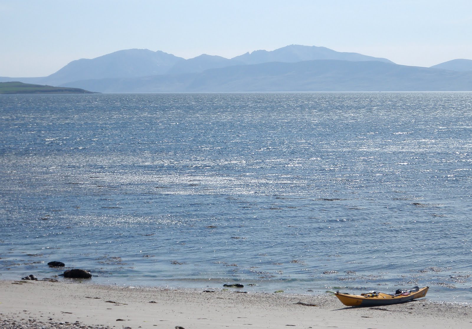
I reached Kildavanan, tired but elated after an entertaining crossing.  The 4 kilometers had taken almost three hours of unrelenting effort.  I was thickly encrusted with salt from the spray and quite hungry! 


Journey's end at Kildavanan with Arran beyond.  The wind still flattening the water in Ettrick Bay, but as ever it didn't look as imposing from the beach.....

I was picked up at Kildavanan - it helps having relatives on the island!

This is a really good trip with variety and wildlife.  In the more usual westerly airflow it would make sense to start at Colintraive and finish in upper Loch Fyne.  The weather for my trip was a complete contrast to that experienced by Douglas Wilcox and friends on their trip in the same area, this variety of conditions and light is surely one of the attractions of sea kayaking in Scotland.

The distances were 36 kilometers on day 1 and 25 on Day 2; add about 20 kilometers to complete the journey through the Kyles.

Four Ordnance Survey Landranger 1:50,000 maps are required for the trip:

Sheet 56 Loch Lomond & inverary
Sheet 55 Lochgilphead & Loch Awe
Sheet 62 North Kintyre & Tarbert
Sheet 63 Firth of Clyde Area

In upper Loch Fyne HW is +0011 Greenock. 
Tidal stream at the narrows runs at 1Kt Springs, but 2Kts close to the end of An Oitir
Tidal streams in lower Loch fyne are not significant.

Tidal streams enter both the East and West Kyles of Bute on the flood, meeting some way east of the Burnt Islands.  Streams may reach up to 3kts at Springs

Tuesday 3 May 2011

Wrinkled rocks and furrowed sea at Ardlamont Point


I'd pitched the tent in near darkness on the inner end of a grassy spit with a lagoon behind. After a breezy night I was woken by natures own black and white alarm clocks - Oystercatchers calling as they started their day.  Soon after, they were joined by trilling Sandpipers and my first sound of a Cuckoo for the year.  Clearly it was time to get up!

I was on the water and away by 0730, continuing south then SSE toward the marina at Portavadie.  I could see a huge cloud of dust being blown from the car parks here across the water.  It was going to be a tough day, and as soon as I turned SSE the wind was in my face.


I was able to slog across the more open stretches, then shelter close to the shore in bays with west facing shores.  Here it was very peaceful and quiet.  Early Spring flowers like these Primroses (Primula Vulgaris) have been joined by some later flowering plants - here Red Campion (Silene dioica) making a nice contrast.


Rounding Rubha Preasach (wrinkled point) the first view of the Arran hills opens up.  The wind tearing across the Sound of Bute in the distance was a warning that the shelter of the bay I was in was coming to an end.


The rocks toward Ardlamont Point become increasingly folded and layered.  Tiny inlets of green water are formed where the beds ride up over each other.  I noted several terrific camping spots for future trips.  This rock gave me some shelter to rest, eat and drink before starting the crossing to Bute.  Plans to journey up through the Kyles of bute to the east side of the island were already gone - I would head straight to the west coast around Ettrick Bay.  In good conditions the 4km crossing would take about 45 minutes.  In the F5 gusting F6 now blasting around Ardlamont Point, I anticipated it would take a tad longer!