Showing posts with label Bridges. Show all posts

Wednesday, 25 May 2022

Bridging the gap

This is a catch-up post from a walk in upper Donside in the second half of April.  Lorna, Allan and I have explored many of the area's tracks, especially when Covid restrictions limited the distance we could travel.

We decided on a linear walk from Corgarff at the foot of the Lecht road down to Bellabeg in Strathdon.  By the A944 road this isn't a particularly long route but we intended to use parts of altogether older roads.  We would also link a series of bridges which have historical interest - the "bridge" theme would continue in that our route would bridge a gap between walking routes we know well.


We set off on a lovely Spring morning, heading SE from Ordgarff along the track which is signed as "Old Military Road".  This simple statement has a deal of history behind it because this is a section of road built between 1748 and 1757 as part of  a massive roadbuilding and infrastructure project following the 18th century Jacobite rebellions.

That said, the first of the bridges isn't typical of the "Wade Bridge", being a graceful, slender arch over the Allt Damh - seemingly defying gravity! 


Just under 2km further along the track is Delavine Bridge.  This is much more representative of the bridge construction on the 18th century military roads.  Delavine was one of three bridges repaired and stabilised over three years from 1997 to 2000 to keep these scheduled monuments intact.  A plaque on Delavine bridge records the work, placed on the outer parapet where it is particularly difficult to read without standing in the burn itself!  It is typical of the larger bridges of the period in construction and in being 4 metres wide.

The familiar term is "Wade roads" and "Wade Bridges" in reference to General George Wade, a military Commander in North Britain from 1724 to 1740.  Wade is actually the only person named in the British National Anthem - one of the more clunky verses which isn't used today reads:

"Lord grant that Marshal Wade
may by thy aid victory bring
May he sedition hush
And like a torrent rush
Rebellious Scots to crush
God Save the King"

The "Wade" road here is part of a 100 mile (160km) route from Coupar Angus to Fort George near Inverness via Braemar, Corgarff and Grantown on Spey.  The whole route was built in nine years between 1748 and 1757, starting just two years after the final Jacobite defeat at Culloden Moor.  For context, the 26 mile/42km Aberdeen Western Peripheral route took five years to complete in the 21st century!

By the time construction of this road was started Wade had long since left the Highlands and in fact died in the same year work on this route started.  His successor, Major William Caulfeild (note the spelling, not "Caulfield") was appointed Inspector for Roads in Scotland in 1732.  While nowhere near as well known as Wade, Caulfeild oversaw far more of the network: Wade was responsible for 250 miles (400km) of road, forty bridges and two forts; Caulfeild  for 900 miles (1400km) of road and over six hundred bridges - an astonishing series of works.   

The road we now walked is part of the longest single stretch Caulfeild built at 100 miles and the line it took was clearly good because the vast majority of the route is still public road, suitably upgraded for modern traffic. This stretch wasn't absorbed into the road network and remains as a great walking route. 

The ingenuity, effort, endurance and craft of the road planners and of the regiments of soldier-navvies who constructed the military road network is a great testament to one of Britain's greatest engineering feats. 


A little over a kilometre further on the road crosses the third bridge of the section, this one spanning the Burn of Tornahaish.  Here also the bridge required restoration works and all three bridges on the section are now leased from the landowner, Candacraig Estate, by the Gordon Trust on a 99 year lease.  Smaller than Delavine and without a parapet, the span and height above what is a very small burn gives an indication of the volume the Burn of Tornahaish is capable of in spate.


The track climbs up from Burn of Tornahaish to join the A939 road, or more properly become the A939 road.  From here the Military Road goes to Gairnshiel then on over the hill to Crathie on Deeside.  We walked uphill for a short way before leaving the road on a track cutting back uphill, having bridged the gap of several kilometres between our previous walks.  Here we had a choice of routes to reach Bellabeg.  One route would take us over to link with a lower level walk we've done before while the other would climb up onto the high ground to cross the summit of Scraulac - a route done several times previously.


We chose the higher level option as the weather was good and we were in no particular rush.  The summit of Scraulac (which I think may be from the Gaelic for Scree Place) is really wide, though today a bit breezy too.  An estate worker passed us on a quad bike here and was the only other person we saw on the entire route.

We left the estate tracks to descend Scraulac's north east ridge, finding a remarkable hidden building en route.  A good track which became a metalled road soon led us down to the public road at Culfork.  This really is a "road less travelled", a loop of minor road running parallel to the A944 but on the opposite side of the river Don.  A relatively new venture along here is Cairngorms Glamping and Camp Site, which looks to be a super place to spend a holiday!


 Cutting off the road just outside Bellabeg, a track descends around a wooded hill to the last of the historic bridges of our walk.  Poldullie Bridge was constructed in 1715 by Sir John Forbes of Inverernan and crosses the River Don. A remarkably graceful single span bridge, the elegant form is best seen from above as in the images on the Canmore site.  Sir John Forbes made a fatal choice in throwing in his lot with the Jacobites at the 1715 rebellion and was captured following the battle of Sherrifmuir.  He died in Carlisle prison the day before the date of his execution.  It was this rebellion which prompted much of the roadbuilding effort in Scotland in order to "pacify" the Highlands.  Movie buffs might recognise Poldullie Bridge as it featured in the 2019 film "Mary Queen of Scots".


From Poldullie Bridge we climbed a steep bank to the main A944 road and strolled downhill to Bellabeg where we'd left a car earlier in the day.  

This had been a great walk with lots of history and great views.  The route we took is 19km/11.8 miles and it took us six hours at a fairly relaxed pace with a couple of stops.  Ordnance Survey 1:50K Landranger map 37 (Strathdon and Alford) covers the whole route.  As there is no public transport between Bellabeg and Corgarff this route does require two cars and a shuttle.  It would also make for a great mountain biking route with scope for variation.

Tuesday, 10 November 2020

Autumn on Etive

Of all the seasons, autumn in Scotland is my favourite.  the colours are at their best and there's a tangible sense of change in the air - I've never thought it to be a season of decline or dwelled on the shortening day length.  Allan, Raymond and I were looking for a sea kayak trip during a period of settled weather in mid-October; we decided on paddling on Loch Etive which we hoped would give us a good trip and allow us to experience the autumn colours from the water too.


Loch Etive is a 30km long, fjiord-like sea loch with its entrance into the Firth of Lorn at Connel, just north of Oban.  When the glaciers carved out the loch and then retreated, a sill of rock was left near the entrance.  This sill limits the flow of water leaving the loch on an ebb tide, with the effect that the level of the water outside the loch drops faster than that in the loch.  From quite early in the ebb a tidal fall forms at Connel where the loch is spanned by a road bridge.  On a spring tide, which it was when we did this trip, the Falls of Lora were in full and spectacular flow.  We stopped to admire the spectacle, and to watch the river kayakers who use the Fall as a play spot.  We, however, had no intention of taking 5 metre fully laden sea kayaks anywhere near this spot on a spring tide and planned to stat our trip some way up the loch!


We gathered at Taynuilt where the loch again narrows but without the excitement of a tidal fall to contend with.  We'd need to paddle against the last of the ebb tide for a short while but were confident of finding eddies along the shore to help us past this short section.  It was a bright morning but with a chilly breeze which was forecast to drop during the afternoon.  Loaded and ready, we got on the water for our short adventure.


Approaching the narrows there are tantalising glimpses of the mountains which line both sides of Loch Etive and give it such character.  I've climbed the hills and walked one side of the loch but hadn't previously paddled here, so was looking forward to exploring as much as we could.


We got through the narrows with little difficulty, though against a bit of a breeze as well as the ebb stream.  The play of light on the hillsides, alternately lighting the rich autumn colours, was lovely - though we noticed a cloud sheet was beginning to form over the area.


As shafts of sunlight became less frequent their effect seemed more pronounced, pefhaps also due to the lowering angle of the sun at mid afternoon.


 All too soon the cloud sheet drew right across the sky, and though the scenery ahead was getting more spectacular the absence of vivid colour took something away.  We certainly weren't complaining too much though, this is a great place to explore by sea kayak - and we had an unexpected treat ahead of us.

Monday, 10 June 2019

Bridging the gap from river to sea


Shortly after leaving Acharacle we approached the first of two bridges on the River Shiel.  This is the "new" bridge, built in 1935 and formed of a fine triple arch.  This is one of two "Shiel Bridges" and not to be confused with the "Shiel Bridge" in Kintail.


The second bridge is a graceful single arch built by Thomas Telford in 1804 over a point where the river is force through a narrow gap.  The "old" bridge was too narrow to carry road vehicles and was replaced by the "new" bridge in the 1930's.  There's actually a channel to the left of the bridge in this image, but in today's low water level it was completely dry.  We've had a little excitement in much higher conditions here but today we drifted serenely through into a quiet zone of deep, slow moving pools.


After a quiet stretch the river changes again to a broad, shallow flow over banks of shingle which required a bit of careful route choice to avoid.


A steep bank on the right hand side is a good reference point to start looking for options to get off the river prior to the drop into the Sea Pool.  This part of Scotland is still rising after the weight of the ice sheet was released at the end of the last Ice Age and is up to 5 metres above sea level.  In simple terms, Loch Shiel and it's river used to be connected to the sea, but are now up to 5 metres above sea level....which means that the water has a bit of a drop into the sea right at the end of the river.


We chose a spot we've used previously to get off the water; at a river gauging station.  There was just enough space for our five kayaks next to the minor road.  The road may be tiny but it's quite busy as it leads down to the popular Castle Tioram.


We got our boats onto the trolleys and one by one set off down the road. 


After 150 metres or so we could leave the road and take an estate track beside the river, so we weren't holding up the traffic!


Each time we've been on this trip we've taken the time to  take a look at the river's final plunge into the sea.  There was a lot less water here than on previous trips - one autumn visit had particularly impressive volumes of water sluicing down.

A common thread on each visit is that we've not had the slightest inclination to run this rapid in fully laden sea kayaks!  Even in this lower flow there are hazards; there's a couple of big rocks submerged in the line of descent.  That said. if you arrive in low river flow and at high water springs, it's said that the descent is straightforward.  Being of the disposition which plans for envisaged conditions....we bring trolleys!


We'd come from freshwater loch to river, under two bridges and then a short portage which had bridged the gap from fresh water to salt water.  Ahead of us lay the charms of Loch Moidart and the open sea.

Thursday, 25 April 2019

A warm welcome at Glenfinnan


In the week leading up to Easter, Allan, Lorna, Douglas and I rendezvoused at Glenfinnan by the head of Loch Shiel.  Under a pale blue sky there was warm sunshine....unremarkable enough except that for the previous two weeks Scotland had been under bitterly cold easterly airflows with low single digit Celsius temperatures.  A change in the source of the airstream across the country had been well forecast - but none of us really believed it until we stepped from our vehicles into 20 C sunshine!


We planned a journey down Loch Shiel to the sea, then along the Moidart coast.  It's a journey we've done previously a couple of times but Allan had missed out due to illness - all the more reason to do it again!  Our last journey down the long length of freshwater Loch Shiel had been in October 2016 when Douglas, Lorna and I had enjoyed a superb display of autumn colours.  On that occasion we'd rustled through the fallen leaves and "conkers" of a big Horse Chestnut tree to get to the launch, on this occasion the leaves of the same tree were just opening - the wheel of the seasons turning.

We ran two of our vehicles to our expected finishing point and had arranged to park one at the Glenfinnan House hotel for a very reasonable parking charge.  If you do this trip - please make sure to check in advance as we did that there will be space to leave a car; the available spaces are restricted and hotel guests will obviously have priority.  The hotel staff told us of a group of Open Canoeists who had arrived without warning, half filled the car park then returned and left without paying - on a holiday weekend when the hotel was full to capacity.


We were soon on the water in a light breeze which gave Allan and Lorna a chance to accustom themselves to sea kayak sailing - for Lorna this was the first time and Douglas had in fact fitted her boat for a sail in the car park immediately before we got on the water!


The pal ochre colours on the hills behind Glenfinnan were definitely still those of early Spring, but the temperatures spoke of summer - it was so good to be back out on the water.


At the head of the loch you can see the two main attractions of Glenfinnan; the railway viaduct and the memorial to the ill-fated 1745 Jacobite rebellion.  The monument used to be the main draw for visitors to Glenfinnan, with the railway viaduct of interest mainly to enthusiasts of railways and concrete construction; it was completed in 1898 of the then new-fangled wonder material by Robert McAlpine who earned the nickname "Concrete Bob".

All this changed with the appearance of a certain Boy Wizard.  The second and third Harry Potter films featured Glenfinnan viaduct and the "Jacobite" steam train as it took Harry and friends to and from Hogwarts.  The explosion in tourism which followed has been nothing short of remarkable.  Traffic congestion is now a daily event and despite a second car park being constructed to accommodate visitors, both are invariably full with cars parked in all sorts of "interesting" places. 


But the Harry Potter lookalikes and the sound of the traffic were left behind as soon as we headed out into Loch Shiel.  Fresh water under our hulls, miles of empty country ahead of us and the sun beaming down....we were off on our own adventures again!

Friday, 31 August 2018

A meeting of waters


Climbing up beyond Bynack Lodge, there's a last long view over towards the main Cairngorm group; Beinn Bhrotain in the middle distance, Cairn a Mhaim and Ben Macdui beyond.  The camera hasn't caught it, but I could clearly make out the cliffs of Coire Sputan Dearg (corrie of the red spouts) to the right of the summit cone of Ben Macdui.


The path towards Glen Tilt then enters a green valley below the hidden Loch Tilt known as Bealaidh Sidhean (fairy pass) , which probably recalls the grim Celtic "Sithean" (pronounced Shee-an) rather than the type of fairies with twinkly green outfits.  I've walked this stretch several times but hadn't previously noticed the small milestone in the mossy ground.  Just about 15cm tall, I think the 15 refers to the miles from Blair Atholl to this point.  It's also just about at the county boundary where one steps from Aberdeenshire into Perthshire.


Having crested the rise and gone "over the hill", the way ahead follows the clear stream of the Allt Garbh Bhuidhe (rough yellow stream) as it enters a narrow valley - ahead there's a glimpse of one of Perthshire's best hills, the multi-summited Beinn a'Ghlo which has three Munros.  I tried to recall the last time I'd climbed that fine ridge and decided it's too long ago....another one to go back to soon!


The Garbh Allt Bhuidhe runs through quite a remarkable gorge which looks like a glacial breach.  The path traverses close to the burn, sometimes at a level with the water and sometimes quite high above across steep slopes.


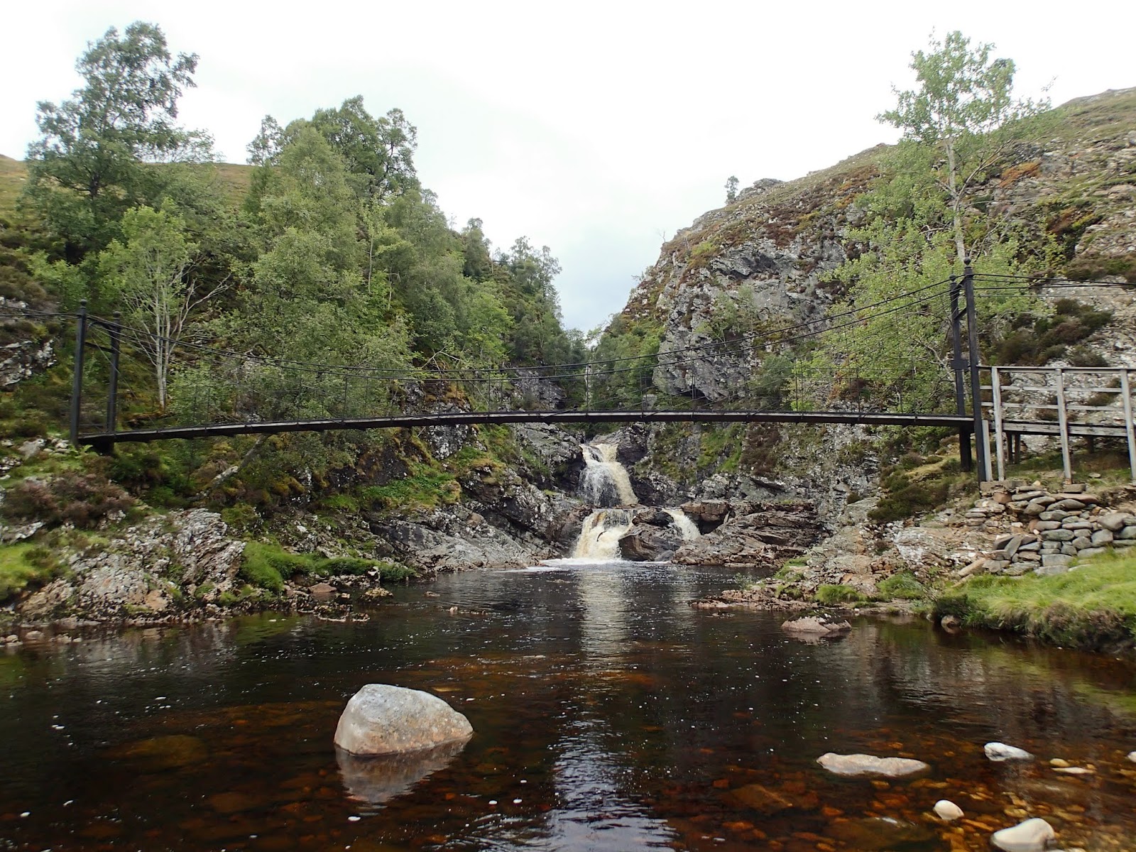
Eventually the burn is joined by the larger Tarf Water at Falls of Tarf, spanned by an elegant iron and timber bridge.  In dry conditions in one of the driest summers for years this is a quiet, pleasant spot; in spate these falls are an impressive sight.


The bridge is known as the "Bedford Memorial Bridge" and commemorates a young man drowned trying to cross the Tarf here in August 1879.  This is a slightly unusual meeting of waters; the Garbh Allt Bhuidhe is joined from the west by the Tarf Water and from the east by the Allt a'Ghlinne Mhoir (stream of the big glen), but from this point the combined waters enter Glen Tilt and are known as the River Tilt.

My route now left the main Braemar to Blair Atholl path and headed up the north bank of the Tarf Water.  There's a path shown on the OS 1:50,000 map, but it's a figment of the cartographical imagination.  The going was terrifically hard on rough and boggy ground, and I wouldn't wish to walk this section again any time soon.


Eventually I arrived at a much flatter area with better walking ground, near the pony stable below Dun Mor.  THe track coming in around the hill can be accessed from Glen Tilt some 3 kilometres down Glen Tilt from the Bedford bridge and if coming this way again I'd use this longer option.

I now had to decide which side of the Tarf Water to use in order to reach my destination for the night; settling for the south side which gave reasonable walking partly on a vehicle track.  After what seemed a long time, my planned accommodation came into view......


.....and after a long and exhausting day, it was a welcome sight - a building standing in splendid isolation in true "mamba" country.

Tuesday, 28 August 2018

Destination "mamba"


Late August in Scotland.  The hills are covered with the purple shades of heather, the sun shines on long days and all things seem possible.  Or......the midges are at their worst, the weather is muggy and oppressive and a heavy green and grey cloak covers the hills.  Towards the end of the month it seemed that there would be a bit of all of these things.  I'd initially planned a sea kayak trip but realised that forecast light winds and overcast conditions along the coasts would mean midge purgatory.

So, I looked for a backpacking trip which would give the opportunity of at least one night in a bothy, giving respite from the biting hordes.  The journey I settled on would take me into some of the most remote country Scotland has to offer - I'd need to be completely self sufficient in shelter and food so that if I didn't make the planned route I could still camp and be relatively comfortable.


Linn of Dee is the starting point for many long walks; to the north you can head off on some of the best known treks in the country; through the Cairngorms from Deeside to Speyside via the Lairig Ghru or the Lairig an Laoigh; or onto the great plateaux of the eastern Cairngorms and over to Donside perhaps.

Heading west, the choice is hardly less enticing - the routes shown on the Scottish Rights of Way Society sign indicate an alternative start to reach the Lairig Ghru and two great through-routes towards the west.

Anyone heading off on these journeys will enter true wild country, and though there are either tracks or defined paths the whole way, the challenges of distance and weather can test the strongest walkers.  Then there are the rivers - the routes to the west require crossings of water which can be running hard and fast; and there are no bridges over two of the most significant rivers.


My plan was to take the first part of the route from Linn of Dee to Blair Atholl, then head into the trackless country west of Glen Tilt to visit one of the most remote of bothies.  This view shows just the first few miles of my route, up the River Dee to the hills beyond.


The first significant river crossing at least has a bridge - White Bridge crosses the Dee and is a meeting point of tracks and paths (though it's not white!).


The view up the valley of the infant River Dee is one of glimpsed giants.  To the left, Beinn Bhrotain at 1108m/3635ft with the flank of the Devil's Point and Cairn Toul beyond -big hills for big days.


After such a dry summer I was confident of finding the water in the next river, the Geldie Burn, low - but I can't ever recall seeing it so low.  The Geldie is termed a "burn" (stream), but make no mistake, this is usually a river and it runs hard and deep in wet weather or during snowmelt; it's often impossible to cross safely and there are no bridges over it.  I've several times arrived here and found it birling along with an ominous rumbling sound of boulders being rolled along its bed - a crossing to treat with caution in normal conditions.

From here on I was entering "mamba" country.  Not referring to venomous snakes, thank goodness, the word is an acronym possibly coined by servicemen sent from southern England to serve in the Highlands and Islands during the Second World War.  "Mamba" stands for Miles and Miles of B*gger All !


Beyond the Geldie a substantial ruin stands in a patch of green sward, a bright spot among the heather.  This is (or was) Bynack Lodge, a ruined 19th century shooting lodge from the days of the great estates.  Perhaps it's the green setting or the trees surrounding the ruin, mainly pines and sycamores, which make this such a pleasant spot; I've always found this ruin a place of peace and have camped here several times.


The ruin has been stabilised by Mar Lodge estate and you can see some of the brickwork used to support the mortared rubble original wall.  There are actually a few ruins here, one building was a game larder with a subterranean meat store, there was a separate building which may have accommodated the staff, traces of kennels, a stable and even a walled garden.

One slightly surreal but enjoyable experience I had here was watching the balcony scene from Shakespeare's "Romeo and Juliet" being performed using the window sill in the left of this image as the balcony - and that can't have happened too many times!


After a final glance through the arched wall aperture back down the Bynack Burn towards Geldie I hoisted my rucksack and headed onwards; there was still a long way to go today, much of it "mamba".

Monday, 21 May 2018

Four seasons in a forenoon


I slept well in my tent, pitched behind Glendhu bothy.  We woke to frozen ground and a dusting of snow which was coming and going in light showers - quite a difference to the warmth of the previous afternoon!

It's often said that in Scotland you can experience four seasons in a day - and we were about to have just such a day. 


Snow was falling steadily on the hills above Glendhu.  Our bothy companions took a look outside and voted unanimously for a late start to see if it would clear.


After breakfast we got packed up, said goodbye to the lads and got on the water in improving conditions.  The wind died completely and the cloud began to break and lift up the crags surounding the head of the loch.  An easy paced paddle took us down to Kylesku in a little over an hour.

Our plan had now evolved a little due to forecast strong winds the following day.  We'd thought of shuttling a car ahead to Scourie and paddling from Kylesku north, using the camp site at Scourie, but the forecast northerlies would have made this a hard slog.  Instead, we decided to drop our camping gear and excess kit at the vehicles in Kylesku, then to explore Loch a' Chairn Bhain, returning to Kylesku to finish.


On the shore opposite the fishing jetty lie the remains of the two-car ferry "Maid of Kylesku".  She served the Kylesku crossing from the 1950's until 1967 when she was replaced by the "Queen of Kylesku" in 1967, which in turn was replaced by the "Maid of Glencoul".  When the Kylesku bridge replaced the ferry service in 1984, the "Maid of Glencoul" was redeployed as a relief vessel at the Corran ferry in Lochaber.

"Maid of Kylesku" was simply beached when she reached the end of her service life in 1967 and it's testament to the strength of her construction that she's essentially still in one piece over fifty years later - although she has certainly seen better days.


Having unloaded most of our kit back into the vehicles at Kylesku, wetook advantage of the strong ebb stream too pass under the Kylesku Bridge at quite a lick.  Rain began to fall steadily as we set out, and soon after we went under the bridge there was a dramatic change in conditions as a squall barrelled in from the north bringing a vicious mix of rain and hail on a suddenly strong wind.


As quickly as it had come in the squall passed through and disappeared over the summit ridges of Quinag, trailing veils of rain as it did so.  The wind dropped, out came the sun and it suddenly felt warm - another of Scotland's weather tricks.


By the time we reached the seaward end of Loch a' Chairn Bhain (loch of the white cairn) we were paddling under blue skies and bright sunshine once more.  I remembered a small pebble beach at the back of a tiny bay where we stopped for luncheon; there are surprisingly few landing places on the north shore of this wide loch.


The colours here were really fine, that alluring mix of white sand under turquoise water, a real treat.  Allan and Lorna were both suffering from heavy colds and decided to go just a little further before turning back.......


.....but first we explored the tiny Loch Shark, a lovely shallow loch enclosed by pine and spruce woods - most unusual for this part of the coast.  As Allan and Lorna began the return leg towards Kylesku, headed north to paddle around the island of Calbha Beag (little calf).


Almost as soon as I turned north the wind began to increase; in the channel between Calbha Mor and Calbha Beag it became a real effort to make progress and I reached the top of the island with some relief.

The north coast of this small island is rugged and steep; the wind had quickly built a swell in the wide open Eddrachilis Bay which was acting against the ebb tide to produce quite sporting conditions - lots of spray, noise and movement.  I was then treated to a fast, surfing run down the west coast of the island taking advantage of the wind-over-tide wave trains....there aren't any photos of this section!

From the still frost of the early morning, to snow, dead calm, hail and rain, bright sunshine and now a barrelling wind; we'd had four seasons in a forenoon never mind a day!  Truly, in Scotland we don't have a climate, we just have weather.......


I spoke to Allan on the VHF radio to let him and Lorna know I was back inside Loch a' Chairn Bhain.  A pleasant paddle took me back towards Kylesku, where the bridge is suddenly revealed when a point which seems to block the loch off is rounded.  This is still one of my favourite bridges, there's a simple grace to it and seen from the ridges of Quinag the curve of the deck seems to fit the landscape really well for a modern structure.


We packed up at Kylesku and consdiered options.  The forecast for the following day was poor and Allan and Lorna decided to head to Scourie to camp before taking a leisurely trip home.  I decided to head home to take the opportunity of seeing visiting family, and started on the journey back across country.

Before I did though, I stopped on the road at a layby with a view up the length of Loch Glencoul - a view familiar to many geology students and one that has few equals from a main road.


Heading over the watershed to the eastern side of Scotland, the higher hills were still plastered white - this is Ben Wyvis, a sprawling giant of a hill visible from a wide area.

A short trip, but a good one in a favourite part of the country; hopefully I'll be back there soon.