Showing posts with label industrial sites. Show all posts

Sunday, 3 May 2020

One good thing - 2nd and 3rd May 2020

One good thing about the weekends is the opportunity to take longer walks without the time constraint of working from home. These longer routes have averaged around 15km and are usually circular, although one of the walks this weekend was linear.


Setting out from home I revisited the route which runs from Alford to Rhynie over the Correen Hills.  Once used as a cattle droving route, it was also used as a path between kirks.  The parishes of Forbes on the Tullynessle side of the hills and Kearn to the north shared a minister and services alternated between the kirks, so on Sundays this route would have been busy with one or other congregation making a return journey over the hill.  This route remains a right of way between Alford and Rhynie and is relatively easy to follow.

From Terpersie a track climbs gently up on a broad spur to a long-disused quarry.  The soundtrack was all moorland birds, the constant backing stream of Skylark song, the sudden "squelch" call of a Snipe zig-zagging away from close by, the chuckle of Red Grouse, the wild call of  Curlews in display flight, and - as expected this weekend the familiar pirate call of a Cuckoo, the first of the year.


The view back down to Tullynessle opens up as height is gained, moorland and forest bounded by rich farmland. 


The highest point of the walk is at a shallow bealach (col) near Badingair Hill from where a wide view opens up to the north with Tap O'Noth crowned by its massive hillfort prominent.  The previous time i walked this route I turned east (right in this image) near the solar array to finish at the village of Clatt.  Today I wanted to follow the traditional route to Rhynie - which goes along the strip along the side solar panels towards Tap O'Noth.


Close up the renewable energy plant is quite impressive.  I had a fascinating chat with a mole-catcher who was checking his traps around the base of the solar panels.  He's one of the last people to specialise in mole catching locally and I learned lots in a short conversation.  The moles here are clearly very numerous judging from the amount of molehills and are presenting a problem not just around the infrastructure but in the livestock fields nearby.


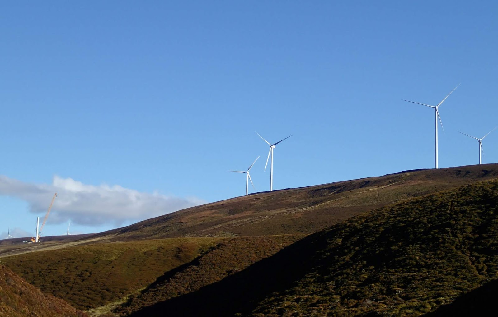
The three turbines at Carnmore are 81 metres tall and each of the blades is 25 metres long, rotating at a nominal 26rpm, each has an output of 850Kw which is claimed to be capable of powering 600 homes.  The whooshing of the blade tips was noticeable but not as intrusive as some.


Nearby is the remains of Cairnmore hillfort - a Pictish site dated to around 500AD.  Not as immediately spectacular as the forts on the summits of Tap O'Noth or Bennachie, it is nevertheless thought to have been a site of high status in the Pictish era and has a wide outlook over the surrounding country and a direct line of sight to Tap O'Noth.

Tap O'Noth was built many hundreds of years before Cairnmore but it's possible that both were in use at the same time for a period.  At this time of year it's likely that huge fires would have burned near both sites at the celebration of Beltane, which has roots very early in history.


An information board gives a good impression of what the site may have looked like based on a series of archaeological digs.

The route from Cairnmore follows a farm road downhill to a quiet country road leading to the village of Rhynie.  If time allows there's an outstanding collection of Pictish symbol stones at the kirk in the village.

This route was a little over 15km and takes around 4 hours including stops. I feel that the finish in Rhynie is a better one than the finish in Clatt. It's another added to my exploration of walks straight from home, and has lots of good things to recommend it.

Monday, 20 April 2020

One good thing - 19th April 2020

The weekend gave opportunity for a longer walk, and one which has been on my list to do for some time.  The enforced restriction to local ventures has focused me on exploring more of what's on the doorstep.  Setting out from home I intended to follow the cattle droving route which linked Rhynie to Alford - though my route would do it in the opposite direction to the drovers.


A short walk along minor roads reaches Terpersie and the small "castle", a 16th century tower house restored to habitable condition which is the earliest dated example of a Z-plan design in Scotland.  Terpersie marks the end of the public road and the start of a hill track leading over the Correen hills.


A long but easy climb on an old track goes up past old quarry workings on a gentle spur to reach the lowest point of the Correen ridge at about 450m/1475ft near Badingair Hill.  The view back is expansive but the whole of the Howe of Alford is hidden from here.


Looking east it was apparent that lots of the snow has been stripped from even the highest Cairngorm hills in the fine and sunny weather which has so far characterised April, the giant Ben Avon holding most patches.


Across the watershed of the ridge a fine view opens up into Strathbogie with Tap o'Noth very and it's huge hillfort very prominent.  Another hillfort site, Carn More, can be made out as a pale mound just beyond the right hand of the wind turbines.

The view is undoubtedly changed by the turbines and the large solar energy array - this is the compromise to be considered if a move to a low-carbon energy economy is to happen.

The drove route leads down past Carn More to the village of Rhynie, it once linked Rhynie with the cattle marts at Alford and Lumphanan.  My route went down to the base of the hill and then I headed west (right in this image) to link farm tracks towards Clatt.....


...with it's pretty church (which has a Pictish symbol stone incorporated into a boundary wall).  This was a 15km walk and a good one.  I'm glad that staying local prompted me to walk this track, next time I'll follow the drove route to Rhynie itself.

Sunday, 26 January 2020

Last sunset of the year

On the last day of 2019 Allan and I took advantage of a some sharp, clear weather and set out on on a walk across one of the local hills, Cairn William.  In fact, this hill is so local to Allan and Lorna that we were able to set out from their back garden!


After a pleasant traverse among the pine woods Allan showed me the former Corennie Quarry - despite having lived in the area for many years I wasn't aware that this was concealed on a rocky hillside within the woods.  Now filled with water, it made a great reflecting pool on this still and clear morning.  The quarry was active in the late 19th century and was quite a hive of activity, there was a smithy and steam powered machinery in place and a trackway linking to the railway which linked Alford to Aberdeen.  Granite from the quarry was used both locally and much further afield - some being exported as far as Australia.


After exploring the quarry we climbed out of the forest and onto the open hillside.  Straight away the views begin to open up....


...especially out over the Howe of Alford , across the village itself and beyond to the Correen Hills.  I could just make out where my house is in the view too!


This last day of the year was bright with a low winter sun.  We'd chosen a route to put the sun at our backs and were glad of it.  Ahead the moor dips slightly before heading over to Cairn William.  We enjoyed striding out on a good path with wide views.


We were soon at the great domes of granite which form the summit of Cairn William.  At 448m/1470ft this isn't a high hill at all but does have good views, and as a bonus it's on our doorsteps!


The view across to Bennachie is really fine, the distinctive shape seen from much of Aberdeenshire is one I instinctively look for in any skyline view.  We didn't loiter on the summit because a chilly breeze had started up, so we headed to the bealach between Cairn William and Pitfichie Hill to have a rest stop.  A quick climb up to the summit of Pitfichie Hill had us warmed up again - and at early afternoon we started back, the sun already low in the sky.


The low winter sun through the trees of the forest was creating some lovely light and shade patterns.  Lorna had walked out to meet us and found us taking a half step left and right to get the best image - as anyone who spends time with me on the hill or water will know, taking photos can take eat hours over the course of a day!


Walking back across the fields near Allan and Lorna's house we were treated to the most delicate of sunsets.  The last day of the year had started gold and blue, it would end in pink and lilac.


We stood until the cold moved us on, the colourful sky enhanced by a soundtrack of thousands of Pink Footed geese heading to Loch of Skene for the night.  What a superb way to end the year!

Wednesday, 6 November 2019

Powered up on Loch Ericht


After our hillwalking diversion we had a cup of tea on the shore before getting back on the water to complete our return leg up Loch Ericht to Dalwhinnie. Near to Corrievarkie is the turbine house for a hydro-electric power scheme.  This station produces 2.2MW of power and is fed from Loch Garry in the hills to the east of Loch Ericht.  There's a 55 metre height difference between the lochs which gives the "head" for the water.  This scheme is part of the larger and widespread Tummel hydro network.


A following breeze was very welcome and we hoisted our sails to get some assistance on the long run back up to Dalwhinnie.


Keeping to the eastern side of the loch, we got a good view of Ben Alder Lodge in its grand wooded setting below hillsides already touched by the blonde shades of autumn.  The stalking season would get into full swing a few days after our visit and there was plenty of activity on the estate road leading down the west shore from Dalwhinnie.


Not long after this image was taken the serene, pleasant paddle-sailing ended.  At a slight twist in the loch the wind began to blow in mighty gusts which were rolling down from the steep slopes to our right (east) side.  We assessed later that these might have been turbulent rolls of wind rushing downslope from the steady easterly flow over the high ground but whatever the cause, the effect was very dramatic.

Before we could drop our sails the wind caught our boats with considerable violence.  I was driven downwind at a terrific rate and had real concern about the sail and mast being torn from the hull of my boat.  For a few moments I had little or no control over either direction or speed and just hung on, bracing hard on the paddle with a rooster tail of spray tailing back from the submerged blade.  I glanced up at the top of my mast and wished that I hadn't, the whole thing was being forced into an arc by the pressure of wind.  As soon as it had started the gust subsided and we dropped our sails hastily.  Checking my GPS later, it had briefly recorded a speed of 15Km/h during this gust.

We continued to experience these gusts until near the top of the loch when the wind simply poured out of a valley, hammering across the loch and making for quite challenging conditions as it blew from the starboard quarter at a solid F6 for some ten minutes.  Then, as soon as we were out of the firing line of the valley, the wind subsided again to almost nothing.  Paddling on Loch Ericht needs careful planning, the orientation of the loch catches the prevailing wind but even in light crosswinds the topography will give tricky conditions at times, with the area between Ben Alder Bay and Corrievarkie seemingly a real wind tunnel.


As we approached the dam which holds the northern end of Loch Ericht our return was marked by the noise of traffic from the nearby A9 trunk road and the slightly strange sight of a Scotrail train belting north towards Inverness.


We pulled into the bay near the inflow of the aqueduct which brings water from Loch Cuaich on the other side of the road and railway.  The water in Loch Ericht is used in it's turn to feed the hydro electric power station on Loch Rannoch, and thence to Tummel in an interconnected hydro scheme.


Our paddle and hillwalking trip had been short in time, but we'd done quite a bit.  In a little over 24 hours we'd covered 47km/29 miles of paddling and done a 10Km hillwalk with around 550 metres of ascent.  Allan remarked wryly that I'd managed to plan three days of a trip into one overnight journey!
Tuesday, 8 October 2019

Summer sojourn on the Moray Firth - Sandend to Whitehills

Our camp site for the night had been the very pleasant Sandend Caravan Park (which also has tent pitches).  Wild camping isn't so easy to find on this part of the coast, so this was a perfect base - especially as we were able to carry our boats straight onto the glorious Sandend beach to launch.


It was going to be another cracking day, hot sunshine, light winds and low swell, ideal conditions for sea kayaking on this predominantly rocky coast.


The fun starts almost straight away with a series of narrow channels piercing the West Head.  Confusingly, this to the east of Sandend....it's actually the West Head in relation to the bigger harbour and town of Portsoy.


Often the swell at this exposed spot is too high to get safely through thes chanels, but no such problem today - it really couldn't have been better.  Allan, Lorna and I have paddled this coast many times and it never pales - but this was Raymond's first visit and it was great to share it with him.


We passed through the third channel at Redhythe Point and paddled slowly on along sheer cliffs.  Raymond asked if this was the end of the rock architecture so early in the day......


...erm, Nope! A fine double arch is the next delight, almost invisible unless you happen across it or know exactly where to look as it's hidden behind a buttressed cliff. A pool at the back can be entered at most states of the tide so that you can paddle it in either direction - or both directions as we did.


A short distance further to the east is the lovely harbour of Portsoy.  Actually two harbours, the older one dating from 1692 is unusual in being constructed of large stones set vertically.  A white sand beach at the back makes for a pleasant stop.  The red boat in this image is a very solidly constructed clinker built traditional fishing boat made in Denmark nearly a hundred years ago and still very much seaworthy and serviceable - she featured alongside Portsoy harbour in the 2016 remake of the film "Whisky Galore"


It's easy to see why you'd choose this harbour as a film location, it has great charm and is very well kept.  Each June Portsoy hosts the Scottish Traditional Boat Festival....when it's a lot busier than this!  Some of the warehouses around the harbour were used to store and trade Portsoy Marble, a red and green serpentine much in demand at one time.  Although the trade is long diminished, you can still buy items made from this unusual stone locally.


A modern addition to the harbour is this very evocative life-sized sculpture of one of the Moray Firth's Bottlenose Dolphins created by the artist Carn Standing in 2016.  It's a striking, graceful piece and adds to the public sculpture which Scotland is becoming so good at hosting and producing.


After a break for coffee at Portsoy we continued east with a warm afternoon sun on our backs, passing a couple of lovely small beaches which are the favoured haul-outs of Grey Seals before landing at a third one.  Difficult of acces from landward, these beaches are almost always deserted and simply lovely places to spend some time.  We almost dozed off in the warm sunshine, with a gentle hiss of rhythmic waves and glorious summer colours to add to the relaxing effect.


The last leg took us along a stretch of lower lying coast with jagged reefs running out to sea - it's a place to be wary in a sea kayak or any other craft.  We continued past the main harbour at Whitehills, once a busy whitefish port but now developed to become the largest leisure boat marina on the Moray Firth.  Our landing point was a tiny harbour to the east, once home to an 18th century brickworks which produced clay pipes as well as bricks.  It was demolished in 1978 and a caravan park now stands on the site.  The tiny harbour gives a good landing spot and there are still lots of brick fragments lying among the pebbles in the harbour.


Our first two days of paddling had taken us from Findochty to Whitehills amongst some of the best sea kayaking anywhere - rock arches, caves, cliffs, channels, friendly harbours, caves, a castle and several stunning beaches - this area really has so much to offer (but we would say that as it's our local patch!).  We still had another day of good weather before strong winds nd rain would arrive...and we had the pleasant dilemma of where to paddle the following day.  We headed back to our camp at Sandend to discuss the options.....

Friday, 21 December 2018

Blowing in the wind on Corryhabbie Hill


Near the summit of Corryhabbie Hill there's a series of small cairns and stone lined hollows.  I can't find much information about their origin, but it's known that Ordnance Survey teams camped on the summit in 1819 and again in 1850.  Sometimes the parties built stone shelters to live in and its possible that these are remnants of the shelters.


A fairly level walk along the ridge with splendid views soon arrives at the 781m/2562ft summit which is marked by a trig point within a shelter wall.  The trig point is topped by a conical metal "hat", something I've not seen on any other trig pillar.   I hunkered down in the lee of the shelter wall to get some respite from the biting cold of a north wind.

In the previous post I remarked on just how expansive the views are from Corryhabbie Hill, and that's why it was selected as a triangulation point for mapping by the Ordnance Survey.  The views have recently been altered completely though - to the east of Corryhabbie is Cook's Cairn, a broad ridge of heather...........


.......the north end of which hosts the turbines of the huge Dorenell Windfarm.  This has been, and continues to be, a very controversial project for a number of reasons.  The Aberdeen Press and Journal (P & J) articles make for interesting reading, as do the ones from Energy Voice.  Whatever the controversies and whatever your opinion of onshore wind energy, the simple fact is that the industrialisation of this hill has changed it forever.


I descended from Corryhabbie Hill to a boggy bealach which drains to form the River Livet on one side and the River Fiddich on theo other, thus providing the raw material for some of Scotland's best known whiskies.  The 120m/400ft turbines dominate the ridge above, the noise of those which are operating was really obvious.


I was glad to get past the windfarm and follow the Fiddich as it curved around towards my starting point at Bridgehaugh.


The final few kilometres were a joy, some warm October sunshine on my back and glorious autumnal colour around me.  I still think that this is a better route to Corryhabbie Hill than the much shorter "up and down" from Glen Rinnes - despite the visual intrusion of Dorenell.

Monday, 1 October 2018

Roll out the barrel (s)


On a recent visit to Speyside we called by a cooperage serving the many whisky distilleries in the area.  There were some nice images to photograph, whether quite plain.......


...or full of vibrant colour.  It's possible, with a little knowledge, to guess the origin of some of these barrels - Glen Grant, Glenlivet, The Macallan and many more from Speyside, as well as examples from far and wide such as Islay's Laphroaig.


I liked this image with the end of a huge stack of barrels lit by sunshine with the backdrop of a storm-black rain cloud.


There are so may barrels here and in other cooperages they seem almost uncountable - and these are just the ones not in curent use; there will be many times more maturing in bonded warehouses throughout Scotland.  This seemingly endless supply is a good thing.....


.......or for enjoying the products of the barrels.  Looks like we'll not be running out of the raw materials any time soon!