Showing posts with label waterfalls. Show all posts
Tuesday, 26 February 2019
A February day in Glen Quoich
February has continued to be unseasonably warm with temperatures more usually associated with late Spring than late Winter. On a "normal" February day a walk up Glen Quoich would need most of the gear required for winter hillwalking, but certainly not this year. The glen is entirely bare of snow and even the mountains only have patches of old snow. So complete is the thaw that the Quoich Water is at a low volume - most of the snow having already melted.
There are some wonderful areas of old growth Caledonian pine forest in the lower part of the glen, standing deadwood mixed in amongst mature pines and, pleasingly, lots of young trees. It's not so many years since you could walk in this area and see lots of Red Deer but very few young trees. The National Trust for Scotland took a decision to reduce deer numbers on the ground and the result is a much more healthy regenerating forest. A healthier forest will also be good for the deer going forward as they're animals of forests rather than moorland.
The spiral grain of a Scots Pine (Pinus sylvestris) can be clearly seen in the dead trunk above. This is a characteristic of the species and seems always to spiral clockwise. It's thought that spiral grain is an adaptation which strengthens the tree and enables it to resist wind stresses better. Some mature pines have huge crowns and of course retain their needles through the northern winter so an adaptation to resist wind stress seems to make sense.
At the opposite end of the scale from the huge dead pine trunk, there are clear signs of the coming Spring, especially in the smaller trees like this Rowan (Sorbus aucuparia), even though the colours of the wood are generally muted at this time of year it won't be too long before the fresh greens of Spring emerge.
Much more colourful was a large granite boulder covered in orange lichen - quite beautiful in it's own way.
At our feet we noticed a number of dark brown or black hairy caterpillars crossing the path. I've not been able to identify the species - so if anyone knows what type of caterpillar this is please let me know!
As hazy sunshine began to break through we looked up to a great view. Across upper Glen Quoich the southern spurs of the sprawling Ben a' Bhuird dominate the view. We sat and "brewed up" tea, enjoying both the view and the warmth of sunshine on our backs.
We kept close to the Quoich Water on our way back down the glen. Flowing off hills of granite rocks, it's a clear lively river. As can be seen by the landslip on the bank in this image, it's also a dynamic river which thrashes around in times of spate.
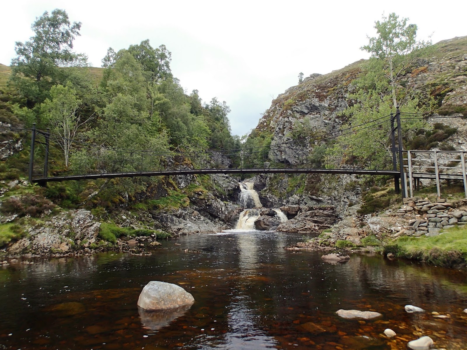
Near to where the Quoich flows into the River Dee is a favourite spot of ours. A series of small falls are formed where the river drops over shelves of rock. One of these rock shelves has a waterworn hollow known as the Earl of Mar's Punchbowl. Local legend has it that the Earl of Mar had this hollow filled with punch during a hunting trip to toast the Jacobite cause in 1715. He'd be disappointed today though as one side of the hollow is worn through allowing water to pour out.
Below the Punchbowl a wooden bridge crosses over the river above the Linn of Quoich (a Linn is a narrow constricted channel) where the whole volume of the river roars onto a narrow gorge. In spate this can be a fearsome sight.
Walking back up from the Linn of Quoich we looked back up the glen to see that a dark bank of cloud had obscured any sun. The forecast was for afternoon rain and it looked like the forecast was absolutely accurate!
The rain passed through during the afternoon, and back at home we were treated to a fine show as the sun set. It had been a very pleasant winter day.....
Wednesday, 31 October 2018
A loch within a loch, an island within an island
The combination of sunshine and cloud seemed to intensify the colours in the trees along the shore of Loch Maree as I paddled slowly back out to the islands.
Between the islands there was no wind at all and the reflections were absolutely pin-sharp on the dark water of the loch. After paddling through a narrow gap between two small islands I aimed straight for the largest of the group to land and explore a little.
It took a while to get through the waist-height heather to find what I was looking for, a location which if not immediately spectacular is quite unusual. On Eilean Subhainn there's a lochan with two tiny islands in it - difficult to see the one in this image. What makes this an unusual place is that here on a loch there's an island, which itself has a loch with an island in it! I don't know of any other place in Scotland where this can be found. Eilean Subhainn is the second largest freshwater loch island in Scotland, only Inchmurrin on Loch Lomond is bigger. If you land and force through the heather to the lochan, check yourself for ticks afterward - even at this late stage of the season I picked up two tiny ones on my arm.
Back on the water and I wound my way through some more of the islands - you can easily spend a full day exploring here and not paddle the same bit of water twice.
Emerging from between two of the islands, a great view opens up to the wild hills of Torridon - hills of great distinction which have given me some great days; and i's been too long since I climbed them!
Heading back to Slattadale I nosed the boat in to the burn flowing from Loch Garbhaig (loch of the rough place) over the "other" Victoria Falls - so named because Queen Victoria was taken to see the waterfall which drops over a small crag into a gorge.
I arrived back at Slattadale in lovely late afternoon sunshine. Having unloaded the boat and put it back onto the car I had plenty of time to make a cup of tea and sit watching the play of light and shade on Slioch - and reflecting on a really good day's fresh water kayaking.
Friday, 31 August 2018
A meeting of waters
Climbing up beyond Bynack Lodge, there's a last long view over towards the main Cairngorm group; Beinn Bhrotain in the middle distance, Cairn a Mhaim and Ben Macdui beyond. The camera hasn't caught it, but I could clearly make out the cliffs of Coire Sputan Dearg (corrie of the red spouts) to the right of the summit cone of Ben Macdui.
The path towards Glen Tilt then enters a green valley below the hidden Loch Tilt known as Bealaidh Sidhean (fairy pass) , which probably recalls the grim Celtic "Sithean" (pronounced Shee-an) rather than the type of fairies with twinkly green outfits. I've walked this stretch several times but hadn't previously noticed the small milestone in the mossy ground. Just about 15cm tall, I think the 15 refers to the miles from Blair Atholl to this point. It's also just about at the county boundary where one steps from Aberdeenshire into Perthshire.
Having crested the rise and gone "over the hill", the way ahead follows the clear stream of the Allt Garbh Bhuidhe (rough yellow stream) as it enters a narrow valley - ahead there's a glimpse of one of Perthshire's best hills, the multi-summited Beinn a'Ghlo which has three Munros. I tried to recall the last time I'd climbed that fine ridge and decided it's too long ago....another one to go back to soon!
The Garbh Allt Bhuidhe runs through quite a remarkable gorge which looks like a glacial breach. The path traverses close to the burn, sometimes at a level with the water and sometimes quite high above across steep slopes.
Eventually the burn is joined by the larger Tarf Water at Falls of Tarf, spanned by an elegant iron and timber bridge. In dry conditions in one of the driest summers for years this is a quiet, pleasant spot; in spate these falls are an impressive sight.
The bridge is known as the "Bedford Memorial Bridge" and commemorates a young man drowned trying to cross the Tarf here in August 1879. This is a slightly unusual meeting of waters; the Garbh Allt Bhuidhe is joined from the west by the Tarf Water and from the east by the Allt a'Ghlinne Mhoir (stream of the big glen), but from this point the combined waters enter Glen Tilt and are known as the River Tilt.
My route now left the main Braemar to Blair Atholl path and headed up the north bank of the Tarf Water. There's a path shown on the OS 1:50,000 map, but it's a figment of the cartographical imagination. The going was terrifically hard on rough and boggy ground, and I wouldn't wish to walk this section again any time soon.
Eventually I arrived at a much flatter area with better walking ground, near the pony stable below Dun Mor. THe track coming in around the hill can be accessed from Glen Tilt some 3 kilometres down Glen Tilt from the Bedford bridge and if coming this way again I'd use this longer option.
I now had to decide which side of the Tarf Water to use in order to reach my destination for the night; settling for the south side which gave reasonable walking partly on a vehicle track. After what seemed a long time, my planned accommodation came into view......
.....and after a long and exhausting day, it was a welcome sight - a building standing in splendid isolation in true "mamba" country.
Sunday, 8 April 2018
A speleological, ornithological, meteorological kind of day (part 2)
Continuing on past the sunny beach where the Stonehaven paddlers were taking lunch, we passed behind a stack and back out towards the open sea through a tall and narrow geo. We reflcted that things would be very different in here during an easterly gale with a big swell!
A little way north of the geo we entered Old Hall Bay beneath the striking remains of Dunottar Castle.
One of the most dramatically sited of Scottish castles, Dunottar sits atop a headland joined to the coast by a narrow neck of land and is protected on three sides by tall cliffs. It's one of the most photographed of castles, but not from the angle which sea kayakers can see it. Most of the ruins seen today are from the 15th and 16th centuries, but there's been a fortification here for much longer.
The "Dun" prefix to the place name indicates that this is a very old fortified site; and there was a Pictish fort on this headland from at least the late 400's AD when St Ninian was known to have converted the Pictish rulers to Christianity and established a monastery. Sacked by the Vikings in AD 900 and rebuilt, Dunottar was attacked again in AD 934 by Aethelstan of Wessex. Through the 11th, 12th and 13th century Dunnotar changed hands between the English and the Scots at least three times, including being taken by Edward I ("Longshanks") in 1296, and retaken the following year by William Wallace. This turbulent history is a mark of the strategic importance of Dunottar and its position dominating the north east coast.
Things were a lot more peaceful on the shore where Allan and I took our luncheon - and there was even some warm sunshine - a rare commodity over the past winter!
The pebble shore in Old Hall Bay is, like most others on this stretch of coast, a mix of rock types. Some will have been washed out in the floods which formed the conglomerate cliffs and some may have been brought down to the sea by the current river systems of the Don and the Dee fourther north. Richly coloured when washed by the ebbing tide, there was real beauty here.
We'd come as far north as we intended, and after lunch began our leisurely journey back to Catterline. Back past the geo and around Maiden Kaim, we found another beach on which to land for a short break.
Against a blue sky the lichens on the rock pinnacles behind the shoore were stunningly bright. A sudden flurry of activity among the birds caused us to look around in time to see a Peregrine Falcon arrowing across the cliffs in a hunting flight.
We met up with some of the paddlers we'd seen on the beach earlier - and it turned out that Allan and I knew two of them, a pleasant meeting. As we chatted the weather closed in and a fairly heavy rain shower passed over. With little wind, it was no inconvenience and seemed likely not to last too long. The full length of the Fowlsheugh cliffs came into view as we rounded Trelung Ness, already beginning to take on a streak of white from the seabird guano.
And there are plenty of seabirds to add to the guano streaks! The sky above us was simply full of birds, mostly Razorbills and Kittiwakes with Guillemots, Fulmars and Puffins also evident - all coming and going to the cliff faces as they establish their nesting sites. It pays to wear a hat hereabouts....and not to look upwards too often!
The scale of the cliff is apparent in this image as Allan paddled around a protuding section; it will soon be a real high-rise city of birds.
Below Crawton a small burn launches itself over the cliff edge and forms an attarctive waterfall (unless a strong eastery is blowing, when no water reaches the sea - it's simply blown back over the RSPB car park). Allan decided to try rinsing his boat before he got off the water!
All too soon we were passing the "wave" rock formation near the entrance to Catterline harbour, just as the sun re-emerged and we finished our speleological, ornithological, meteorological kind of afternoon paddle.
The trip from Catterline to Dunottar and return is a little over 16km, but more distance can be taken if you explore all the cliffs and geos. Parking is very limited at Catterline and used by Montrose Diving club on Tuesdays and Sundays through the summer. A one way trip can be done starting or finishing at either Stonehaven or Inverbervie which is a similar distance to the return trip described here.
The whole coast here is exposed to the North Sea and can get considerable swell and clapotis. Very calm conditions are recommended if you want to explore the many caves. Once the birds are nesting (usually late April to July), you should keep well out from the cliffs to avoid disturbance.
Tuesday, 21 February 2017
Going with the flow
We left Eilean Fhianain with a brisk easterly breeze at our backs - one of the reasons we'd chosen this particular trip was the predominantly easterly wind which was forecast - it would either be at our backs or we'd be sheltered on the west coast.
A last look back towards the mountains of Loch Shiel.......
...and then steadily onwards along the stretch of water which isn't quite Loch Shiel and isn't yet ruly the River Shiel. Shallow water lined with salt marsh, this is a great place for waterfowl and waders to feed and to rest.
Talking of feeding and resting.....
....we landed near the jetty at Acharacle in order to check out the options for first luncheon. Acharacle (Torquil's ford) is named for a Norse leader who was killed here along with all his men in a battle with Somerled, Lord of the Isles in 1120. Torquil's men found the water too deep to cross and they were killed making a last stand near this spot.
We walked up the small road which leads from the wooden jetty to the village shops......where we had a choice of eating in at the Acharacle Tearoom or purchasing lunch to eat outside the Bakery.
As we were in our paddling clothes - and it was anyway such a nice morning - we chose to eat outside the Bakery. The coffee and Foccaccia bread are particularly recommended by your reviewers!
Acharacle is a handy stop in this area, it has a couple of options for food, a shop, and public toilets with a tap outside for topping up water.
Fuelled up and rested, we got back on the water, our boats being drawn along by the now noticeable current towards the fine triple arched road bridge over the River Shiel, built in 1935. The footings of the bridge supports were clear of the water which certainly hadn't been the case on our winter trip, and the river flow was markedly less too.
Shortly after the road bridge the river narrows quickly and swings into a rocky gorge. At the end, the old bridge crosses the river at the point of a ninety degree left bend. Built by Thomas Telford in 1804, it was too narrow to carry motor vehicles and was replaced as a road bridge by the 1935 version. You can walk from the road to this bridge and cross it, but the south side is private property.
Beneath the bridge is a small rapid where the water runs over a rocky shelf - with more water in the river it can prove exciting, but as the level was quite low it was little more than a quickening of the flow.
The rapid marks the end of the narrow section, the water slows and the river becomes wide and shallow. A wooded hill makes a lovely backdrop to a very relaxing section of the trip where we were able to just go with the flow in the literal sense.
If making this journey when the water level is relatively high, it's good to know that there are a couple of potential egress points to allow a portage around the tidal fall where the river empties into the sea. The first is at a gauging station marked by wires crossing above the water - we used this during our winter trip when the river was quite full.
The second point is a small patch of flat grass jutting out into the river, which Douglas, Lorna and I used to land and carry our boats up to the track alongside the water; Mike found a spot further down again, but after that there's just one option immediately above the falls - miss it and you're committed....
We put the boats on the trolleys we carried specifically for this section and portaged along the estate track through woods of beech and pine - despite pulling the boats this was a very pleasant section. Once again the trolleys (three KCS Expedition models and one Lomo model) proved their worth and performed faultlessly.
A short detour to view the tidal fall is well worth the effort - if only to assess whether you feel it could have been paddled. The drop from river to sea is the result of isostatic rebound, the continued rising of the land in this part of Scotland following the release of ice from the last ice age. The fall itself is affected by two things; the amount of water in the river and the height of tide - in simple terms, when the tide is low the river has further to drop. On neither occasion we've been here have we felt the slightest inclination to run the fall in fully laden sea kayaks......
This is the fall in comparatively low river levels but also a low tide.......

.....and this is the fall on our winter trip with more water in the river but a higher tide.
Immediately beyond the point where the river ends, we arrived at the shore of Loch Moidart. We carried our boats down over a patch of saltmarsh to place them, for the first time on this journey, into salt water.
Labels:
Acharacle,
autumn colours,
Bridges,
food and drink,
fresh water paddling,
kayak trolley,
KCS Expedition Trolley,
Loch Moidart,
Moidart,
portages,
River Shiel,
sea kayaking,
waterfalls
Wednesday, 31 August 2016
Kingdom of the wind - down to earth
From the summit of Ben Avon my return route went northeast across the plateau to the tor of Stob Bac an Fhurain (Point of the bank of the spring). From this outlying summit a broad ridge leads down to the dome of Da Druim Lom (Two bare ridges) above the River Avon. Part way down the ridge is perhaps the most impressive of ben Avon's many granite tors - Clach Bun Rudhtair.
The view while descending this ridge is very fine, with Lochnagar particularly prominent across 20km of clear air.......
...but it was the view nearer at hand which really caught my attention. Across the corrie, below West Meur Gorm Craig ("Meur Gorm" is blue finger) there's a tantaalising view of the green jewel of Lochan nan Gobhar (Little loch of the goats). Highlighted in a flash of sunlight the water seemed intensely green and I mentally stored this as the destination for a future walk, perhaps even a wild camp.
From the top of the ridge Clach Bun Rudhtair had looked fairly insignificant, close to hand it's a formidable outcrop of weathered brown granite which reaches 25 metres above the ridge. Despite its position quite low down the ridge, the top of this tor is at 914 metres or 3000ft. The central blade has a "window" right through it and I scrambled up to take a look through - it's quite an awkward scramble and fairly tight at the window itself.
Clach Bun Rudhtair (the name possibly translates as stone of the foot of the peat stack) was appropriatley described by Dr Adam Watson in the SMC guidebook to the Cairngorms as resembling Rhinoceros horns. Below the tor the ground levels out before taking a final steep drop to reach the River Avon, where a short way downstream the main track from Inchrory up Glen Avon is met.
I'd spent many hours high up on Ben Avon where the predominant shades are those of muted greens and the delicate pinkish brown of Cairngorm granite. When coming back down to a glen after a day high up the smells and colours always seem very striking, and on this day the effect was particularly noticeable on the track by the River Avon.
The damp ground adjacent to the track was studded with two of Scotland's carniverous plants, the pale green starfish-shaped Butterwort (Pinguicula vulgaris) and the deep red Round Leafed Sundew (Drosera rotundifola). Both live on poor, wet ground and supplement the lack of soil by trapping insects on sticky parts of their leaves.
The Butterwort's leaves curl over to digest the unfortunate insects trapped by the sticky surface with a cocktail of enzymes. In the case of the Sundew, insects are trapped by a sticky "dew" secreted on the leaves and contact initiates a touch stimulus causing the nearest tentacles to bend inwards - remarkably this can start within ten seconds of an insect becoming trapped. The leaves take about a day to close fully and remain shut for one to two weeks before opening to release indigistible parts of the insects. Both species typically trap very small insects of about midge size, but Sundews can trap surprisingly large insects across several leaves.
Another plant of damper ground and a real late summer indicator is the Bog Asphodel (Narthecium ossifragum). The flower spikes open to a brilliant yellow cluster on 10-20cm stems and seem to fairly glow in sunshine. When the flowers have died in autumn the spikes of pale, bleached Bog Asphodels can last well into the winter.
On the track margins in dry and well drained ground were large areas of Wild Thyme (Thymus polytrichus), the intensely coloured flowers a magnet for bees and hoverflies in the warm sunshine. Getting close to the plants to take photographs, the herbal scent was really strong - the leaves make a very tasty addition to wild camp meals too!
The flowers along the way helped to ease the 3km walk along the rough and stony track to Linn of Avon, a favourite spot which never loses its appeal. I'd left my bike in the heather by the track here to speed the way back over the hill to my starting point at Cock Bridge. The track climbing out from Inchrory over to the bowl of the Feith Bhait is quite steep...and was quite beyond me staying on the bike after 20km of hillwalking...I gave in gracefully at the bottom and pushed the bike up!
Fortunately it's pretty much all gently downhill from there on, finishing with a fast stretch of cycling on the tarmac estate track leading to the car park below the gaunt castle at Corgarff to end a really enjoyable day.
Labels:
Aberdeenshire,
Ben Avon,
Cairngorms,
Castles,
Corgarff Castle,
Flowers,
Glen Avon,
hillwalking,
Linn of Avon,
mountain biking,
Munros,
Plantlife,
River Avon,
rock formations,
waterfalls
Subscribe to:
Comments (Atom)


