Showing posts with label sea colours. Show all posts

Tuesday, 31 May 2022

Over the sea from Skye


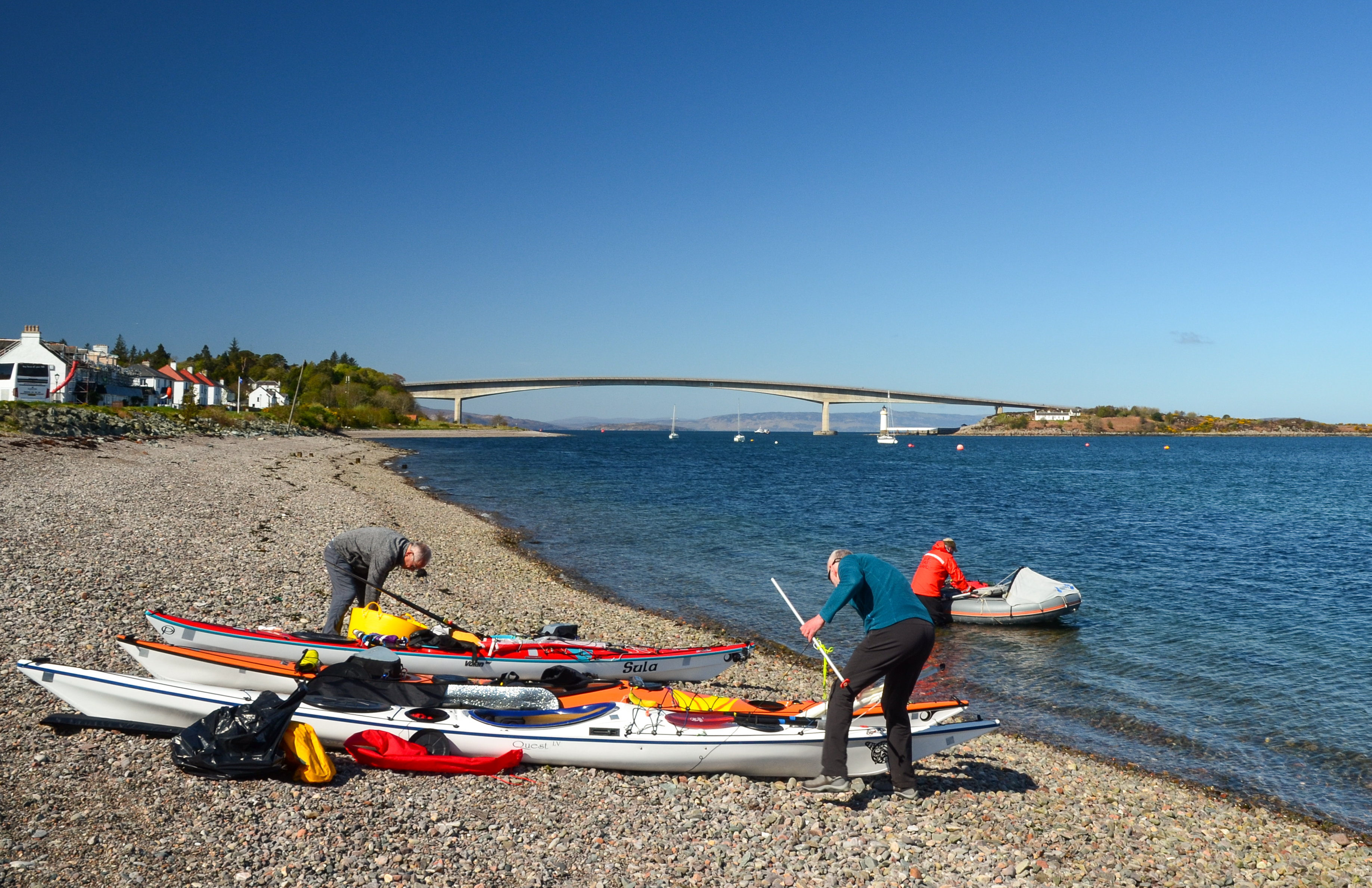
A spell of warm and sunny Spring weather is always so welcome here in Scotland - so when a run of fine days was forecast in the second half of April we made plans for a kayak trip.  Our starting point was to be Kyleakin on the Isle of Skye; and we met up on a sparkling morning.  Allan and I travelled from Aberdeenshire, Douglas from the Solway coast via Glasgow and Taynuilt, where he teamed up with Donny for the journey to Skye.  Our plan was very flexible....simply to spend some time kayaking around the southern part of the Inner Sound.

While we rigged our kayaks Donny got his F-RIB "Guppy" afloat and set off to do a little filming.  You'll be able to see the video of our trip on Donny's Youtube channel here.  


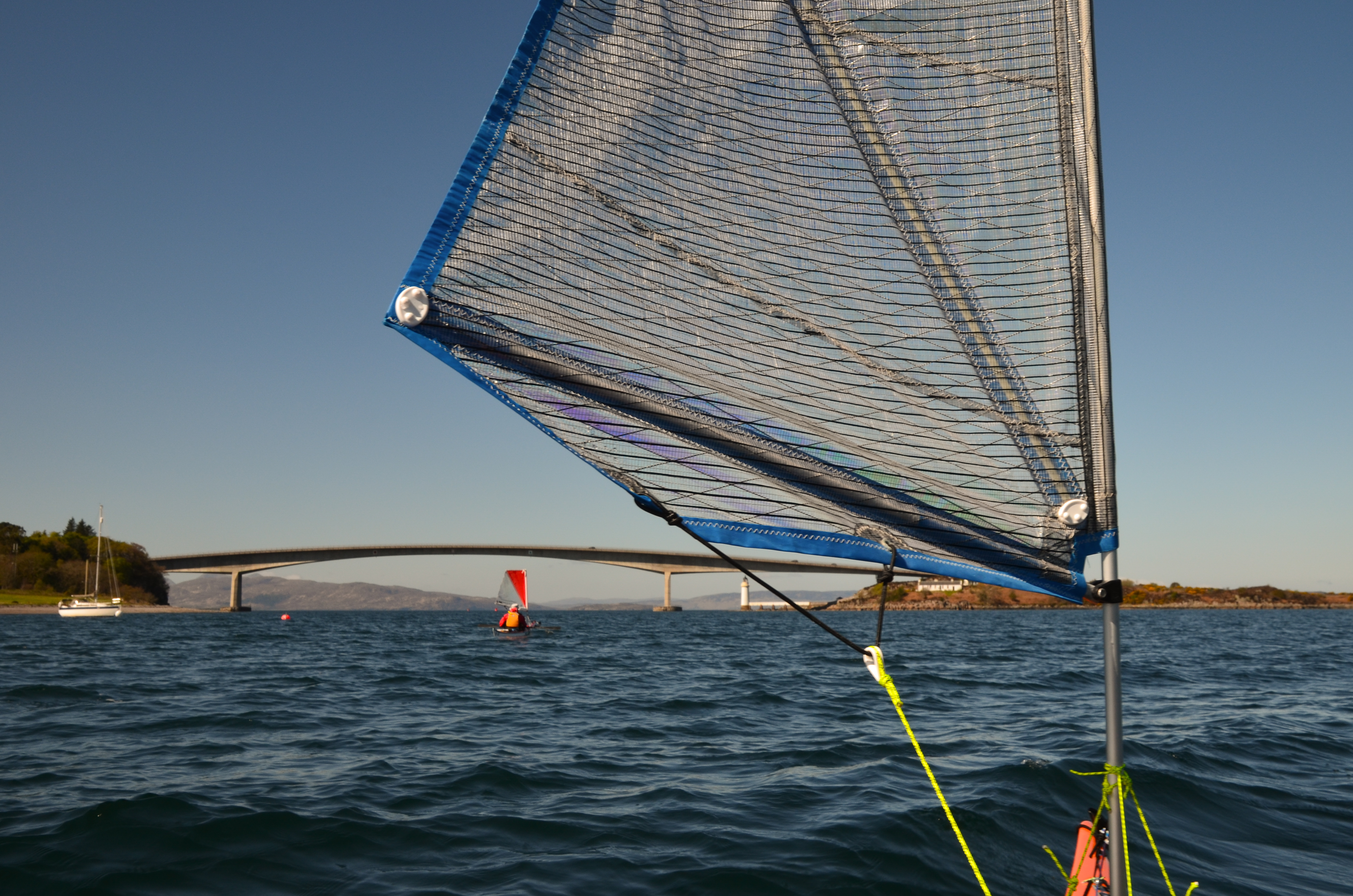
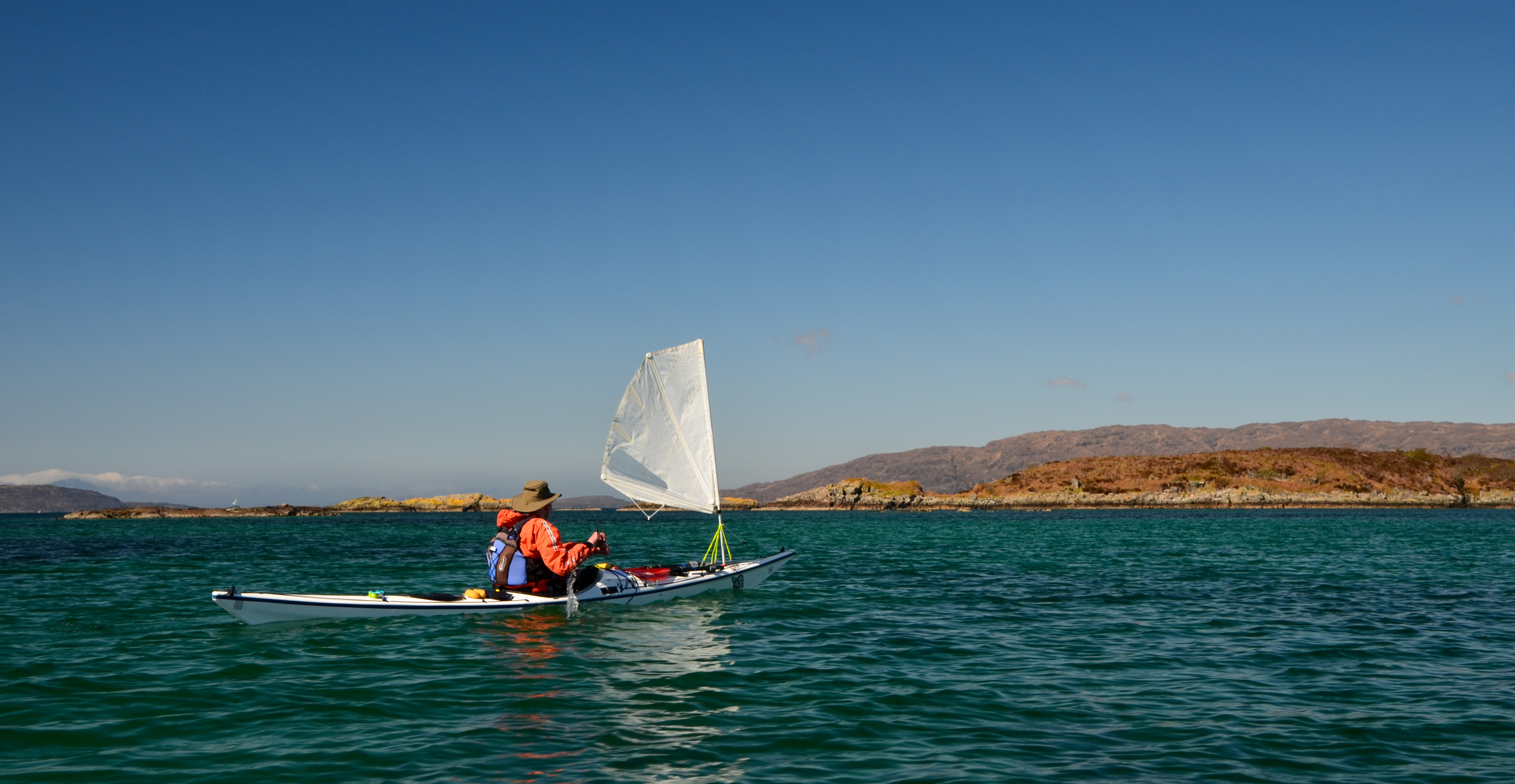
After the usual routine of boat packing and trying to make sure everything fitted in, we got underway and immediately put up our sails to catch a push from the north easterly breeze.  This stretch of water,  Kyle of Lochalsh or more properly Caol Loch Ailse (Strait of the Foaming Lake) has strong tidal streams, particularly at the narrow western entrance which is named separately as Kyle Akin (Haakon's Strait) - named for a Norse king who brought a huge force of longships through here and beached at Kyleakin on his way south where he would be engaged and beaten by a Scots army under King Alexander III on 2nd October 1263.


The building of the Skye Bridge altered the flows somewhat at Kyleakin and the strongest of the stream can be avoided by passing close under the eastern side between Eiean Ban and the mainland shore - that said it's still an energetic paddle against the tide!

We started on Skye and apart from a brief call back at Kyleakin didn't plan to paddle any of the island's coast on this trip - not so much "Over the Sea to Skye" as over the sea from Skye!


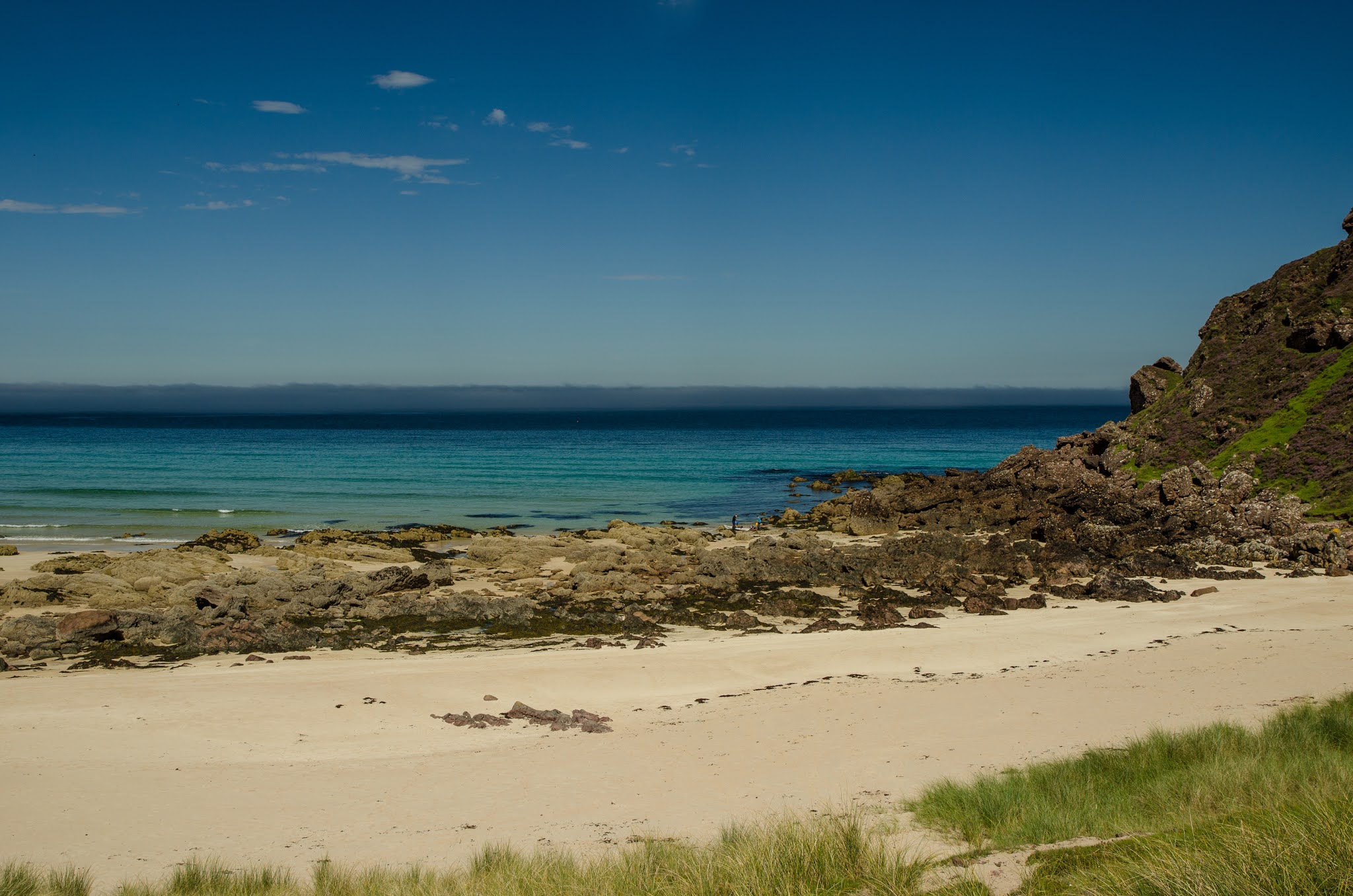
We headed north after exiting Kyleakin and stopped at Eilean a' Mhal for first luncheon. Sheltered from the breeze we sat in warm sunshine with a wonderful view across the Inner Sound to the hills of Beinn na Cailleach and Glamaig on Skye.  The colour in the water was marvellous and was the standout feature of this day.


Back underway and we continued north through the maze of the Black Islands, which today were anything but black - indeed there was a riot of colour.  This group of islands usually provides sheltered paddling in a compact area which changes from hour to hour according to the state of the tide.


Conditions were pretty good for early Spring - dry and bright with a north easterly breeze, and we observed this effect of cloud capping some, but not all, of the higher hills several times during our trip.


 As we left the Black Islands we paddled into the breeze and so dropped our sails.  After an energetic couple of kilometres of paddling we came into a lagoon with the most wonderful colour of water as the sun lit the white sand below our boats.  Really - could a day get any better than this?!

Monday, 14 September 2020

Stacks of colour at Rubha Reidh

The point and lighthouse at Rubha Reidh marked the extent of our outward journey on this superlative summer day.  We turned and headed back around the point, pausing to investigate the tiny jetty at Port an Amaill which was used to supply the light with paraffin and stores for many years - the narrow, twisting road from Melvaig to Rubha Reidh was only completed in 1962.


Seen from the west the stacks are even more impressive than our initial view from the east as they stand out from the cliffs.  It's a great place to explore with a sea kayak and one can paddle in and around the narrow channels at the base of each stack - so we did!


A last run between tow of the larger stacks in perfect conditions brought us back out to the eastern side....


...and back out into the riot of colour in the bay of Camas Mor.  I'd rate this pace, in these conditions, as one of the best places I've ever explored by kayak - just superb.


Image by Allan McCourt

We took turns to pose in our boats for photographs, seemingly suspended on brilliant aquamarine water which would grace a tropical island.


After spending time just absorbing the intensity of the colours we headed in to a small beach we'd spotted on our outward leg.  If Camas Mor is difficult of access on foot, then this beach takes it to another level.  At spring tide high water it will pretty much disappear and is guarded by rocks and reefs, but if you make it here, and it's possible to land, we recommend that you do so.....


 ....we promise you won't be disappointed!  An utterly superb beach, surrounded by dramatic rock architecture and lapped by a sea of stunningly intense colour; it's a great place.

Tuesday, 1 September 2020

Smooth headland, smooth going

We left Camas Mor with some reluctance, it's a lovely spot and one that's usually difficult to land on.  Ahead of us the sea shaded from aquamarine to indigo and every shade of aqua blue in between.  The cliffs are high here and we began to pick out the stacks near to our destination.


A glimpse of another strip of pale golden sand caught our attention - and if Camas Mor is difficult of access then this beach takes it to another level.  Backed by rugged, loose cliffs it would be a tricky scramble down and back.  The scale of the place is put in perspective by the group of walkers on the skyline near the lowest cliffs......


We were now paddling in emerald green water - an indication of some depth over a sandy seabed.  The sandstone stacks rose up in front of us, intricate and challenging.


When we came to shallower water the sea colour changed again - bright turquoise alternating with a deep green where patches of laminaria weed grow from the seabed......


...while behind us the emerald green was stunning - flashes of light darting across the seabed as the bright sunshine was refracted off the ripples on the surface.


As if this couldn't get any better, the colour of the water intensified close to the stacks, which added their own warm red shade to provide contrast.


Against an intensely blue summer sky, the contrast of the sandstone's red was startling.


 Suddenly, we were past the stacks and the height of the land fell quickly to Rubh Reidh (the smooth headland).  Rubh Reidh is named for the appearance of the sloping slabs.  These are of a different type of sandstone, termed autoclastic (made of itself) and are understood to have been sediments broken and tilted 30 degrees to the northwest, possibly by earthquakes.


Across the headland, Rubh Reidh lighthouse stands tall and distinct, visible from many miles up and down this northern coast.  Built by David Alan Stevenson between 1908 and 1912, the tower stands 25 metres tall (37 metres above the sea) and shows four white flashes every fifteen seconds.  I've travelled this coast in large vessels and the intricate chain of lights is perfect, each distinct and in just the right place - one of the great engineering and navigational feats.

To be here, at the Smooth Headland, in smooth conditions was a real treat.  I've walked to the light and tried three previous times by sea kayak to turn this point; each time conditions were too big for me.  the tide sweeps around at 3 knots, it's absolutely exposed and despite it's lack of height is described in yachtsman's pilot books and the sea kayak guide to the north west as "the most dramatic and challenging of the Wester Ross headlands".  We felt pretty lucky!

Tuesday, 25 August 2020

Under the Eagle's gaze at Camas Mor

Continuing from Rubha nan Sasan we left Loch Ewe and began to head west towards Rubha Reidh.  A couple of low-lying skerries came into view and we just managed to squeeze between them and the mainland at quite a low tidal state.


The rock architecture began to grow again in stature as we paddled out of the loch; I remarked to Allan and Lorna that this spot was the furthest I'd previously managed in two attempts to reach Rubha Reidh from Loch Ewe (and one attempt from Gairloch when I didn't get far up the coast before it became to rough to safely continue.  So far everything was looking good.  We weren't the only ones enjoying this sunny morning either.....


I got a glimpse of a huge and unmistakable shape wheeling away above a small headland, and another huge shape atop a post.  A view of a White-Tailed Eagle (Haliaeetus albicilla) is always a thrill and this bird stayed obligingly on it's perch as we paddled below.  It was well aware of us as the head with its massive beak occasionally swivelled to stare at us as we passed by.  The bird had chosen its viewpoint well; as we rounded the headland on which it sat a great view into Camas Mor (big bay) opened up.....


It's an impressive place; a sweep of golden sand backed by steep grassy cliffs and in any kind of swell it has a reputation as a pretty difficult landing.  No road or easy path leads here either, to reach the place on foot is a long walk on a rough path, then a steep scramble down the 150m cliffs.  On this day conditions were about as perfect as you could wish, so we made our approach and landed on the sand among some reefs at the near end of the shore.  

First luncheon was most definitely in order, but before that I walked up the beach to explore a bit and to get a view right along the beach.


I deliberately kept my focus on the small sights, saving the wide view until I was in just the right place.  The only tracks here were animal tracks; whelks moving across the wet sand left their trails - these two forming a neat saltire shape.


A sandstone boulder had really interesting lichen patterns - I picked out the the outline of a heart shape and a turtle in the patterns....or is it just me?!


From the base of the cliffs I looked back to our landing place among the reefs, the view a layered one of green marram grass, golden sand, warm coloured rock, aquamarine water shading to deep indigo and a thin bank of sea mist below a blue sky.  It was lovely, but if the view over the beach was good.....


The view along it was superb!  We enjoyed a leisurely first luncheon, followed by a swim.  We can report that despite the warmth of the day, the sea temperature was on the bracing side of refreshing...though refreshing it certainly was.  It took no time at all to dry off in the sunshine and we ere soon ready to get back on the water; we were leaving as a double kayak and a RIB were arriving.  Camas Mor is a beautiful beach, and the fact that it's difficult of access by land or sea adds to its appeal.  But for all it's grandeur, we were to find out that it's not even the best beach on this stunning stretch of coast.

Thursday, 9 August 2018

A crossing from Eigg and the colours of summer

We had a leisurely start in our camp at Kildonnan, there was a strong north easterly breeze blowing as we ate our breakfast but the forecast was for the wind to drop as the morning went on.  We had a back-up plan which involved taking the lunchtime ferry to Mallaig if the wind remained strong, though we were very much hoping to complete the journey back to the mainland under our own steam.


The forecast was accurate and the wind had dropped markedly by mid morning.  We got underway and headed out from the shore of Eigg, knowing that it's an island we'll return to.


The conditions were just about perfect for sea kayak sailing - we hoisted our Flat Earth sails and felt the immediate increase in speed as the sails filled and began to pull strongly.  The was a short chop in some areas as the tide swirled up the Sound of Arisaig which only added to the fun........


....and we weren't the only ones enjoying the conditions.  This fine traditionally built yacht was absolutely spanking along and we got a cheery wave from her skipper.

The wind dropped to a very light breeze as we neared the Arisaig shore and we once again felt the full heat of the midday sun.  We were aiming for the beach at Port nam Murrach which had been the jumping-off point for our outward crossing two days previously.  The enclosed channel is quite difficult to locate from seaward, but a GPS waypoint kept us straight.....


....and we were soon cruising in to the idyllic little beach with jade green water beneath our kayaks.


The clarity of the water in this bay always delights, the colours change with the state of the tide and the reflection of the sky. Eigg is prominent in the seaward view, some 14 kilometres across the Sound of Arisaig.  With the assistance of our sails the crossing had taken a little over two hours without undue effort.

We were pleased to have been able to paddle out to Eigg, circumnavigate the island, climb to its highest point and then to paddle back to the mainland. Our journey wasn't over, but we now had a the remainder of the day to spend cruising the Arisaig coast, and we planned to spend an further night on the journey too.


In contrast to the morning we set out to Eigg we had the beach at Port nam Murrach to ourselves.  We enjoyed a leisurely luncheon stretched out on the cropped turf above the sand, absorbing the atmosphere of the place.  The machair  and rock outcrops were studded with the bright colours of early summer flowers, so we took some time to just stroll around and enjoy them.


Thrift (Armeria maritima) was at its very best, the seemingly delicate flowers nearly all open in the bright sunshine.  This is one of my favourite wildflowers, it's equally at home on salt-lashed shorelines and right to the summits of our mountains - a truly tough little plant.


Three different plants in this image,  the tiny purple flowers are Wild Thyme (Thymus polytrichus) - the leaves of which can be used to add a lovely flavour to camp food.  The yellow flowers are Birdsfoot Trefoil (Lotus corniculatus) which hadn't fully formed the red buds which give it the alternative name "Bacon and Egg plant".  Between the two, a White Clover (Trifolium repens), a useful fixer of nitrogen in soils.  All these plants are favoured by bees and hoverflies and we saw some of the mining bees for which this site is known feeding on the flowers.


This tiny succulent plant was growing in amongst the boulders - I think it might be English Stonecrop (Sedum anglicum) - but I'm not at all certain. 


I'd been mildly surprised that there was nobody else at this popular spot, and as we put our lunch things back in the boats, a guided party of kayakers arrived.  They'd paddled out from Arisaig and had been enjoying seeing the seals among the skerries in Loch na Ceall before heading down to Port nam Murrach for lunch.  What better introduction to sea kayaking could there possibly be to padle in a stunning location with great wildlife, calm seas and dazzling beaches?!


Mike had joined me in searching the shore ...... and we were delighted to find a few "Groatie Buckies".  There's a risk in finding one though; as those who paddle with me will know, hours can pass while I indulge in this addictive pastime! Having found a couple each to add to our jars of these lovely little shells, Mike managed to persuade me that it was time to go.....


In the space of about 30 minutes while we'd been intently looking at the sand in search of shells there had been quite a change in the weather.  A cloud sheet had formed, the breeze had disappeared completely and the air felt heavy and warm - it seemed that there might be some thundery weather.  We discussed possible spots to camp for the evening and decided to dawdle along the coast of the Sound of Arisaig towards Loch nan Uamh to assess a couple of places we've used previously.

Monday, 9 July 2018

Luskentyre

With yet another superb sunny day in prospect during our stay in Harris, we headed out early to visit one of the places which draws people to the island.  Luskentyre beach (Traigh Losgaintir) is probably the most visited of the many beaches of Harris.....


......and it really isn't hard to see why.  You approach the beach from a car park near to a cemetery, sited on machair behind a dune system; presumably the cemetery is here because all the other nearby ground is too rocky for burials.  Emerging from the dunes, you find yourself on a broad beach of flawless white sand......


.......which forms a broad arcing sweep reaching out to the Sound of Taransay, with a view of the island of Taransay beyond.


We were early enough to have this wonderful beach almost to ourselves, with just the company of terns overhead and the regular sound of the waves for company.  One or two folk who were dots in the distance gave scale to the scene, and they continued out of sight as we strolled along the edge of the waves.  The "proper" name of this 2km long beach is Traigh Rosamol, but it's almost universally known as Luskentyre from the crofting settlement nearby.


In a fresh breeze the surf was piling in, the water turning from turquoise to emerald green as the rollers heeled over, "smoking" spray as they did so, then to dazzling white as they broke with a roar.  We could easily have stayed just watching this play of light and sound all day.


We strolled along an empty beach, absorbing the atmosphere and the light of the place.  Turning around, the view if anything was even finer with the morning sun lighting the hills of North Harris beyond the surf and the blue, blue sea.

Luskentyre is one of the "must do" places in the Outer Hebrides for many people and consequently sees lots of visitors - but this is comparative, it will never really feel crowded.  We did think that we'd seen it at it's best though, a huge sweep of beach bathed in light and colour - we felt absolutely privileged.

Tuesday, 19 June 2018

The black sheiling of Loch Crabhadail


The curving beach of Traigh Mheilein is a delight; a bold curve of dazzling white sand backed by dunes.  The seabed is also white sand for most of the width of the shallow Caolas an Scarp, and reflects light in beautiful aquamarine shades. I paddled along the length of the beach, then around Rubh an Tighe (point of the house) to land on yet another fine beach.


Even though it's comparatively sheltered, the beach at Loch Crabhadail (pronounced "Cravadale") clearly sees some big swell; the boulders at the top of the strand are of considerable size.  This is a quiet, empty spot, but it hasn't always been empty.


Between a small freshwater lochan and the beach, a distinctive pattern on the ground tells of different times when this land was farmed.  The system is known as rig and furrow, more commonly known as "lazy beds" (feannagan in Gaelic).

Scarcely can a more inappropriate term have been applied than "lazy".  The ground here is unpromising and poorly drained, so in order to grow crops it had to be modified.  The rigs were dug by hand and would have been built up using a mixture of sand and seaweed to make a usable gowing medium.  The furrows between the rigs helped to drain the soil and allowed potatoes and mabye some barley to be grown.  Usually the beds were re-made each year, sometimes at right angles to the previous year though here at Crabhadail they may have stayed in the same alignment due to the narrow site and the drainage to the lochan.  It must have been back breaking labour, but necessary to avoid starvation.  And, if that doesn't seem hard enough, when seaweed was in demand for making potash for glass and soap, many landlords banned their tenants from using it for fertilising the soil.

The line of an old wall can be seen at the end of the lazy beds, perhaps built to both shelter the crops from the wind and to keep out cattle.

What now seems an idyllic, lonely place would probably have held a couple of families - and although it's a beautiful setting, you can't live on a view.  This place was a sheiling, used mainly in summer by the people of Scarp and called Am Bhuaile Dubh (the black shieling).  Often it was the young folk and women who worked the sheilings, many Scarp and Harris men went away to work the herring fishery as the fish moved around the coast to the North Sea.


The remains of a couple of small houses can be seen, probably single roomed with low drystone walls and turf roofs.


The larger enclosures were used to confine cattle at night to stop them getting in at the crops; by day the beasts were herded away from the sheiling to graze.  There's a great deal of information about Scarp and the Crabhadail area on the Isle of Harris website -well worth a read.  As ever, these "rickles o' stanes" make me think about the people who made their lives here - all gone now.


Bogbean was flowering in the lochan, the waves on the beach were a gentle rhythm and above the crags a Golden Eagle turned on a thermal.  On this sunny day, Am Bhuaile Dubh and Loch Crabhadail were peaceful and evocative.  On another day just like today I'll come back here and camp in order to spend some time exploring and absorbing something of the place.