Showing posts with label Perthshire. Show all posts

Monday, 28 October 2019

A small diversion from Loch Ericht


Allan and I were up and about early after a comfortable night at Ben Alder Cottage bothy...and as expected the only sounds of footsteps and activity through the night were of the mouse, and not the ghost variety.  We emerged into a gloriously bright morning...


...and soon after breakfast had our boats packed and ready to go.  Both boats were somewhat lighter as we'd brought in firewood for the evening, some of which was left for the next occupants.  One small advantage of fresh water paddling is that boats don't need to be lifted above a high tide mark, so there's less distance to carry them back to the water...though this isn't always the case....


As we paddled out of Ben Alder bay we got a great view back up the loch.  There was hardly any breeze and our paddling seemed effortless; a nice contrast to the effort we'd had to put in the previous afternoon.


The first leg of our return journey along Loch Ericht took us across the loch and up the eastern shore to land in a bay north of Corrievarkie Lodge; another of the Ben Alder estate properties.  As we passed a fairly narrow part of the loch the breeze got up considerably; something we'd note for later in the day. We changed into walking boots for a short diversion; first steeply up an estate road to a bealach, then a turn to the west ups very steep ground.  It was a bit of a steep slog, but we think worth it....


...for the stunning view up the length of Loch Ericht.  There's no enhancement in this image, the water was really this vividly blue in the crystal clear air (which we were sampling at a copious rate having climbed 500 metres in one steep lift!).


When we arrived at the summit of Stob an Aoinach Mhoir - at 855m/2805ft one of the "Corbetts" the views just kept coming.


Back down the loch into Perthshire, with the entrance to Ben Alder Bay on the right


And across the loch to Ben Alder itself - at 1148m/3766ft it's one of the highest hills around and visible from much of the central Highlands.  The nearest transverse ridge links Ben Alder's plateau to Beinn Bheoil - it makes a superb round and possibly all the better because it's a fair day's walk just to get to the base of these hills.


To the south east the skyline was silhouetted in the morning sunlight.  Schiehallion is prominent on the left - a pointy hill standing apart in a central Highlands view is pretty likely to be Schiehallion.


Instead of returning to the road, we took the north ridge off Stob an Aoinach Mhoir; appropriately the name is peak of the big ridge and kept to the crest to maintain the view for the longest time.   We reckon comparatively few people climb this Corbett via the loch route, the vast majority will use the estate road from Loch Rannoch.


The last steep decent was rough and at the base of the ridge there's dense forestry to negotiate, but it made for a good descent.  There's a good view down to Corrievarkie Lodge - our boats were in the bay near to the hydro station in the far right of this image.

It had been a very well worthwhile diversion from the paddling to climb the hill - the effort was more than well rewarded with the view - save the hill for a good day!

Monday, 10 September 2018

A "mamba" Munro and the simple joy of a path


I slept deeply and long at the Tarf Hotel, waking 8am, an unusually late hour for me. A combination of tiredness after a long day and the deep silence of these empty miles on a calm night, plus the absence of the usual bothy mice rustling about were all factors.  I felt refreshed but a bit slow when I got up, and it was after 9am when I set out into a morning with a lid on it.  Cloud levels were down to just above the bothy, the air was still and had that heaviness which often characterises the month of August in the Highlands.  A look back at Feith Uaine; splendid isolation and a haven in truly wild country.


I followed the Tarf Water downstream for a short distance before striking off up a side stream.  A little way up the hill I passed a ruined shieling, evidence that this hasn't always been an empty landscape.  Shielings were summer dwellings used in the traditional transhumance of people and beasts to higher pasture in the summer months.  Sited in the crook of a burn (stream) on relatively level ground, its interesting that the surrounding ground is an area of grass among square miles of heather and moss - I wonder whether the site was chosen for this characteristic, or if the ground was cleared of heather to provide better grazing for the cattle?


Continuing uphill on increasingly rough and difficult terrain brought me to a huge area of peat hags and wet ground.  scattered through the peat hags were the bleached roots and stumps of a long-gone pine forest which once covered the land.  A combination of a cooling climate and felling for timber destroyed these forests - allowing the build up of peat which has left vast areas of empty country.

Soon after this image was taken I walked up into the cloudbase and visibility was reduced to less than 50 metres.  I continued to follow a tiny burn uphill until I reached a bealach (col) between the Munros of Carn an Fhidleir and An Sgarsoch - and also on the Perthshire/Aberdeenshire boundary.  I now had a decision to make.  My next destination was a path which reaches high up the Geldie Burn and lay 3 kilometres to the north of the bealach.  I could either continue a traverse across steep, rough, wet and pathless terrain in low visibility to locate this path, or go over the summit of An Sgarsoch.  The latter route would add a kilometre in distance and 300 metres/1000ft of climbing but would make for easier walking and navigation, despite the additional climb.  After a little deliberation I chose the route over An Sgarsoch and began the steep climb up a broad ridge of grass and moss.


The challenge of accurate map and compass navigation in poor visibility is something I enjoy to a certain extent.  Although carrying a GPS receiver in my kit I resisted using it and was pleased to arrive right at the summit cairn.  An Sgarsoch (the place of sharp rocks) is 1006m/3300ft and one of the more remote Munros.  The last time I climbed this hill I recorded in my journal having a good view, but no such luck this time; the inside of one cloud looks pretty similar to the inside of another!

Unusually for a Munro there's very little in the way of paths on the hill so my navigation still had to be accurate.  I elected to head due north to reach the bump of Sgarsoch Beag (little place of sharp rocks) from where I'd be able to head straight for the path.  This descent proved to be not straightforward as the ground falls away at unexpected angles.  Just as I was tempted to check my position by GPS the ground started to rise and I found the summit of Sgarsoch Beag.


I came out of the cloud just above the path and dropped wearily down to it.  I'd had over four hours of pathless and rough ground, much of that time in poor visibility.  The simple pleasure of being able to relax and walk on a path felt really good, despite the long miles still to go with a full backpacking load.


The path leads to the ruing of Geldie Lodge, another former shooting lodge in a remote spot.  In contrast to the atmosphere of Bynack Lodge, I've always found this place to be an austere setting.  Just below the lodge there's a crossing of the Geldie which leads to the start of a track heading back towards Linn of Dee.


It would have been tempting to have thought the route to be just about finished, but it's 12 kilometres from Geldie Lodge to Linn of Dee, a long way when already tired.  My usual routine on the hill with day kit is to take a short rest every couple of hours or when exploring something interesting; if carrying backpacking kit it's usually a short rest each hour.  My pace dropped on this route back and I found myself having to dig deep.  On the last stretch from White Bridge to Linn of Dee I was resting every ten minutes - I've rarely been so utterly done at the end of a two day route.

This trip into "mamba" country had been a real pleasure, apart from at the start and end I saw not another person in 55 kilometres of walking.  If solitude is your thing - you'll usually find it at the headwaters of the Tarf and Geldie.

Thursday, 6 September 2018

Checking in at the Tarf Hotel


After a 24 kilometre walk, parts of which were on trackless and difficult ground, it was good to arrive at the "Tarf Hotel".  The actual name of the place is Feith Uaine (green channel or marsh) and it's a bothy maintained by the Mountain Bothies Association.  One of the most remote and difficult to reach of the hundred or so buildings maintained by the charity, Feith Uaine is some 15 kilometres or 10 miles from any public road and lies at 650 metres/1750 feet altitude among country which can fairly be described as "mamba" (miles and miles of b*gger all).


The alternative name for the building of "Tarf Hotel" comes in part from the Automobile Association (AA) hotel sign which adorns the front door - in fact it seems that at one point there were two of these signs which must have been "liberated" from a hotel somewhere.

Neil Reid has written a very comprehensive history of the place on his excellent Cairngorm Wanderer blog - very well worth a read.  The renovation of this bothy has left it in perhaps the best condition since its glory days as a hunting lodge for the Duke of Atholl, and arguably drier than at any time in its existence.


"Checking in" at a bothy is uncomplicated....find a space and unpack.  Each time I use a bothy it strikes me what a unique and precious institution they are - simple shelters, free to use, not bookable and open to all who need them - operating on trust and the goodwill of the owners of the estates on which they lie. In a quite remarkable relationship, estate owners make the buildings available and the MBA keep them in good order. I'm a member of the MBA and have been for many years, though this isn't any kind of condition for using bothies; and confers no privileges other than the knowledge that one is helping to keep the institution going.

Unsurprisingly I was the only occupant and so was able to spread out a bit in the west room.  Basic though bothies are, you'll notice that there's a smoke detector above the window; there are also a carbon monoxide detectors through the building.  I tested all these so that I could include the fact that they were working in the bothy report I would submit.  It's helpful for the MBA and particularly the Maintenance Organiser (MO) for each bothy to receive reports from users; it's a simple online process which can be done here on the MBA website.

In comparison to most, the Tarf Hotel is quite a big and well equipped bothy - let's take a tour.......


There are three main rooms in the main building and one attached at the east end.  The three internal rooms are accessed via the main door and an internal corridor. The room at the west of the building is the largest, this is the one which would have been occupied by the Duke of Atholl and his wife when visiting the lodge.  Originally dry-lined with wooden planking, it now has stone walls which are fee of damp, and a large window.  This room and the middle room have had their timber floors re-layed. There's also a substantial multifuel stove - but if you want heat from it you'll need to bring the fuel all the long miles on your back!


The middle room is somewhat smaller and may have been the kitchen.  A bit more spartan than the other rooms, it is nevertheless dry and clean.


The eastern internal room has retained the timber lining, paited white to increase the light levels.  Tables and chairs plus a small sleeping platform complete the furnishings.  This seems to have originally been the room occupied by the Duke's retainers, then refurbished for use by the Duchess with the "hillmen" being moved to an external building.


A metal roof and new chimney pots were installed by the MBA in 2013 - and the bothy is completely dry and weathertight.  Perhaps the most significant change is the external room at the east of the building, accessed by a door on the north side.  This is shown in old photos as originally being an open porch, though it did have a fireplace.  The transformation is quite remarkable.....


The new room is of wood construction above the original stone wall and seems very well insulated - it felt warmer in this room, perhaps partly due to the windows catching sunlight.  The last time I visited Feith Uaine it was in fairly poor condition, but all is now changed. The work that's been done here, given the location and the logisitics of getting people and equipment in (there are no roads or tracks for many miles) is nothing short of heroic.

I returned to the west room and prepared dinner whilst reading through the entries in the bothy book.  Tales of epic walks and that recurring theme, the navigational difficulty of locating a bothy door in remote country and in challenging weather.  Turning in for the night, I considered myself pretty privileged to be in this place.

Friday, 31 August 2018

A meeting of waters


Climbing up beyond Bynack Lodge, there's a last long view over towards the main Cairngorm group; Beinn Bhrotain in the middle distance, Cairn a Mhaim and Ben Macdui beyond.  The camera hasn't caught it, but I could clearly make out the cliffs of Coire Sputan Dearg (corrie of the red spouts) to the right of the summit cone of Ben Macdui.


The path towards Glen Tilt then enters a green valley below the hidden Loch Tilt known as Bealaidh Sidhean (fairy pass) , which probably recalls the grim Celtic "Sithean" (pronounced Shee-an) rather than the type of fairies with twinkly green outfits.  I've walked this stretch several times but hadn't previously noticed the small milestone in the mossy ground.  Just about 15cm tall, I think the 15 refers to the miles from Blair Atholl to this point.  It's also just about at the county boundary where one steps from Aberdeenshire into Perthshire.


Having crested the rise and gone "over the hill", the way ahead follows the clear stream of the Allt Garbh Bhuidhe (rough yellow stream) as it enters a narrow valley - ahead there's a glimpse of one of Perthshire's best hills, the multi-summited Beinn a'Ghlo which has three Munros.  I tried to recall the last time I'd climbed that fine ridge and decided it's too long ago....another one to go back to soon!


The Garbh Allt Bhuidhe runs through quite a remarkable gorge which looks like a glacial breach.  The path traverses close to the burn, sometimes at a level with the water and sometimes quite high above across steep slopes.


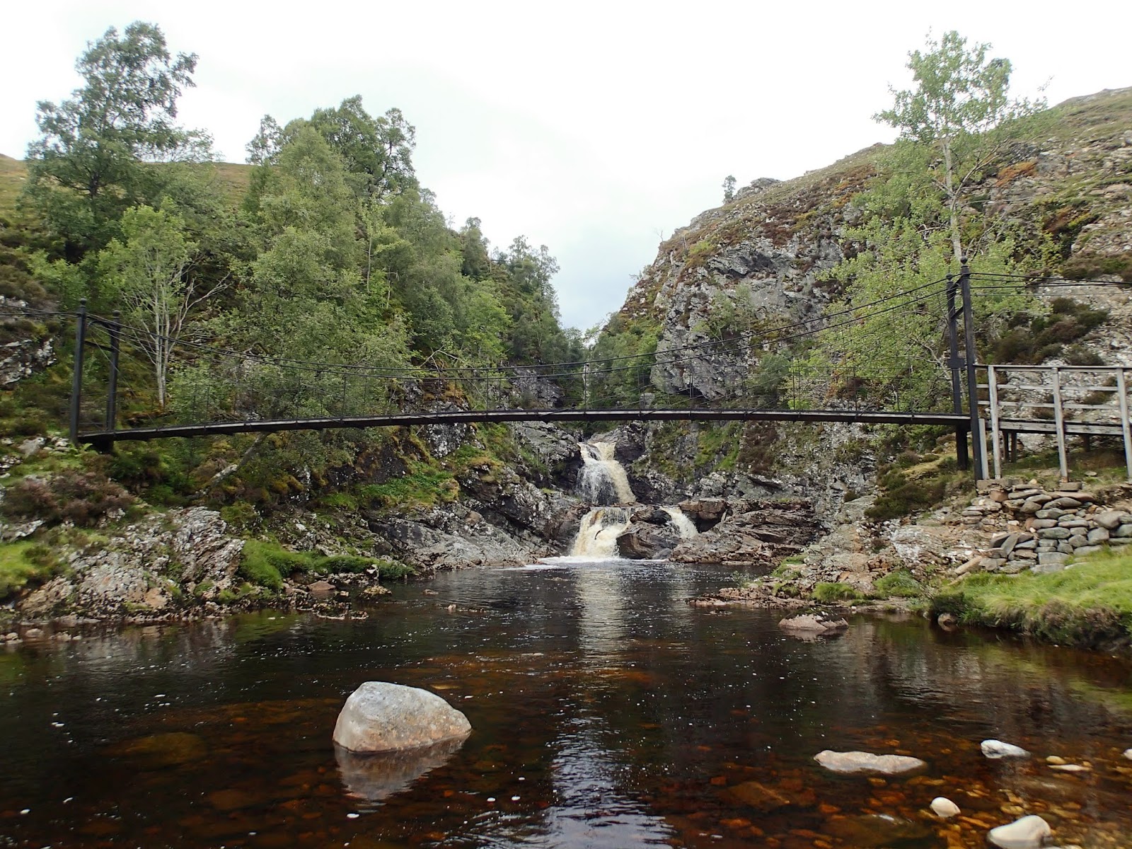
Eventually the burn is joined by the larger Tarf Water at Falls of Tarf, spanned by an elegant iron and timber bridge.  In dry conditions in one of the driest summers for years this is a quiet, pleasant spot; in spate these falls are an impressive sight.


The bridge is known as the "Bedford Memorial Bridge" and commemorates a young man drowned trying to cross the Tarf here in August 1879.  This is a slightly unusual meeting of waters; the Garbh Allt Bhuidhe is joined from the west by the Tarf Water and from the east by the Allt a'Ghlinne Mhoir (stream of the big glen), but from this point the combined waters enter Glen Tilt and are known as the River Tilt.

My route now left the main Braemar to Blair Atholl path and headed up the north bank of the Tarf Water.  There's a path shown on the OS 1:50,000 map, but it's a figment of the cartographical imagination.  The going was terrifically hard on rough and boggy ground, and I wouldn't wish to walk this section again any time soon.


Eventually I arrived at a much flatter area with better walking ground, near the pony stable below Dun Mor.  THe track coming in around the hill can be accessed from Glen Tilt some 3 kilometres down Glen Tilt from the Bedford bridge and if coming this way again I'd use this longer option.

I now had to decide which side of the Tarf Water to use in order to reach my destination for the night; settling for the south side which gave reasonable walking partly on a vehicle track.  After what seemed a long time, my planned accommodation came into view......


.....and after a long and exhausting day, it was a welcome sight - a building standing in splendid isolation in true "mamba" country.

Friday, 18 October 2013

Beyond grey....


It has been a generally damp and grey week in central and eastern Scotland, the hills obscured by mist and low cloud and the light levels lowered. But even in this muted setting there is vibrance and energy in the autumnal days. 

Whether that may be the flash of white and a surge of water stained teak-brown from the peaty hills of Perthshire at the Linn of Tummel.....


...... the delicate shades of pink and yellow in ripening acorns on the oak trees in the campus of the University of Stirling.......


....... the stiking contrast of a glowing yellow aspen between two Caledonian pines at another Linn, this time the Linn of Quoich.......


 ........ the golden yellow of a fallen birch leaf on a gravel path.........


........or the bold red of a rowan (sorbus) seedling in a bed of green heather.  Making the choice to get out in grey, misty and wet weather can be richly rewarded.....


Wednesday, 16 October 2013

The Enchanted Forest 2013

In what has become something of an annual family tradition, we visited The Enchanted Forest event last weekend as a group of six adults and five little ones aged between 2 and 8 years. Held each October at Faskally near Pitlochry in Perthshire, the event fuses light and sound effects to create a unique experience in a woodland setting around a small loch.


Each year has a different theme and arrangement, which must be challenging for the designers.  This years theme is "absorb" with the emphasis on the "Orb", featuring circles and globes as a linking theme.  That could range from the literal circle or globe to the circle of life and beyond!  Once again, the whole event lived up to high expectation.


Visitors are taken to the site by bus, a five minute journey from Pitlochry, and are then met at the entrance and shown the start of the path.  Once in the site, you can stay as long as you wish with bus departures back to Pitlochry every ten minutes or so through the evening.  The fun starts with a large orb overhanging a circular area - useful for family photos!


We were fortunate to get a dry, clear evening this year, though in truth the weather isn't a major factor in the enjoyment of the event.  In fact sometimes rain and mist can enhance the effects.  The path is well surfaced as ist's normally a popular Forest Enterprise walk.


There are eight main areas to the display, one of which stood out as truly exceptional - an orchestral piece with a stunning lightshow.  The lighting is superb, but really it's the combination with the forest and the loch, the utilisation and blending with natural elements which makes the whole event work so well.


The subtlety of some of the effects this year was a real highlight (if you'll excuse the pun!) .  Aside from the main displays, there are rocks from which mist and light appear to emanate, groups of small blinking eyes watching visitors watching back and much, much more.


A central bridge which last year was lit in ultraviolet shades with water cascading from it was transformed into a shimmering path of light visible from most of the site.  Along the way is a large  Yurt (tent) where a storyteller is in residence, regular sessions are given through the evening at a very nominal additional charge of £1.


The loch itself forms the setting for one of the main displays with globes appearing to float over their own reflections and respond to music and sound, changing colours and pulsing with light.


Away from the main displays, colour and light continually shifts through the trees whilst individual trees are lit around the paths to provide both light and a striking effect.


The route around the site feels like a proper journey but is short enough that little ones can manage it comfortably.  Many folk go around more than once, as we did with the eldest little one.


The Enchanted Forest runs until 27th October this year.  If you have children, grandchildren or simply a bit of child-like wonder, it's highly recommnded!


Tuesday, 13 August 2013

A honey scented walk up Mount Blair


Mount Blair is a small hill at the south end of Glen Shee and is on the border between Perthshire and Angus.  It's classified as a "Graham", a Scottish hill between 2000 and 2500 feet in height.  I've often noticed it when driving the A93 road between Braemar and the south as although not a big hill it has a prominent location and is crowned with a telecommunications mast.

As I was driving this way and had an hour or so to spare, I thought it would make a nice short climb.


The ascent leaves the B9150 right on the Perthshire/Angus boundary and pretty much goes straight uphill over grassy ground grazed by sheep and cattle.  Thistles are coming into flower, the vivid flower heads bright against a cloudy sky.


Heather is also in full bloom and the air was filled with a glorious heather-honey smell.  The gentle ridges to the east made for some nice angles


The upper slopes of the hills here are carpeted in the paler Ling heather (Calluna vulgaris), and in places a bit lower down this is mixed with the darker Bell heather (Erica cinerea).


A dust of pollen coats both boots and trousers as you walk through the heather, the sound of bees is ever present.  Higher up the hill a chilly breeze was blowing, but the heather scent was still strong.


At the summit the large telecommunications mast is a bit of an intrusion but can be ignored except for the noise of the wind in the rigging holding it together.  A view indicator was installed here but is now in a bit of disrepair, although inside the  circular windbreak  a plaque commemorating several prominent local landowners is still in place.  The large cairn is possibly prehistoric and is reputed to hold a more recent suicide's grave.


 Mount Blair sits right at another boundary, that between highland and lowland ground.  To the north the view is absolutely highland with the green trough of Glen Shee winding up to the bigger hills of the southern Cairngorms.  Close by are the Angus Glens, long parallel valleys cutting into the Mounth hills between the Cairngorms and the North Sea coast.


To the south the view is much more lowland in nature with the  mix of farmland, moorland and forest which makes Perthshire such a varied county.

 I varied my descent to take in a heathery ridge to the east and add a couple of kilometers to the walk.  Perhaps appropriately, I put up a couple of young Red Grouse on my way down to the road.  This was the "Glorious Twelfth" - 12th August being the start of the Grouse shooting season in Scotland.

The whole walk took less than two hours - as a hill to climb for some exercise on a journey either south or north it's a great choice and a super viewpoint too.