Showing posts with label Loch Linnhe. Show all posts
Monday, 22 May 2017
A Cuil view
The cool northwesterly breeze dropped overnight but the sparkling sunshine of the previous day was replaced by an overcast and murky morning. The long view up Loch Linnhe from our camp with snow capped Ben Nevis looks cold, but in fact it was a reasonably mild morning.
We decided to paddle straight across the loch before any breeze might start up and create the sort of choppy conditions we'd enjoyed the previous evening. Landfall of the Morvern shore was made near the Glensanda superquarry, which as ever comes a a jarring intrusion into the loch scenery.
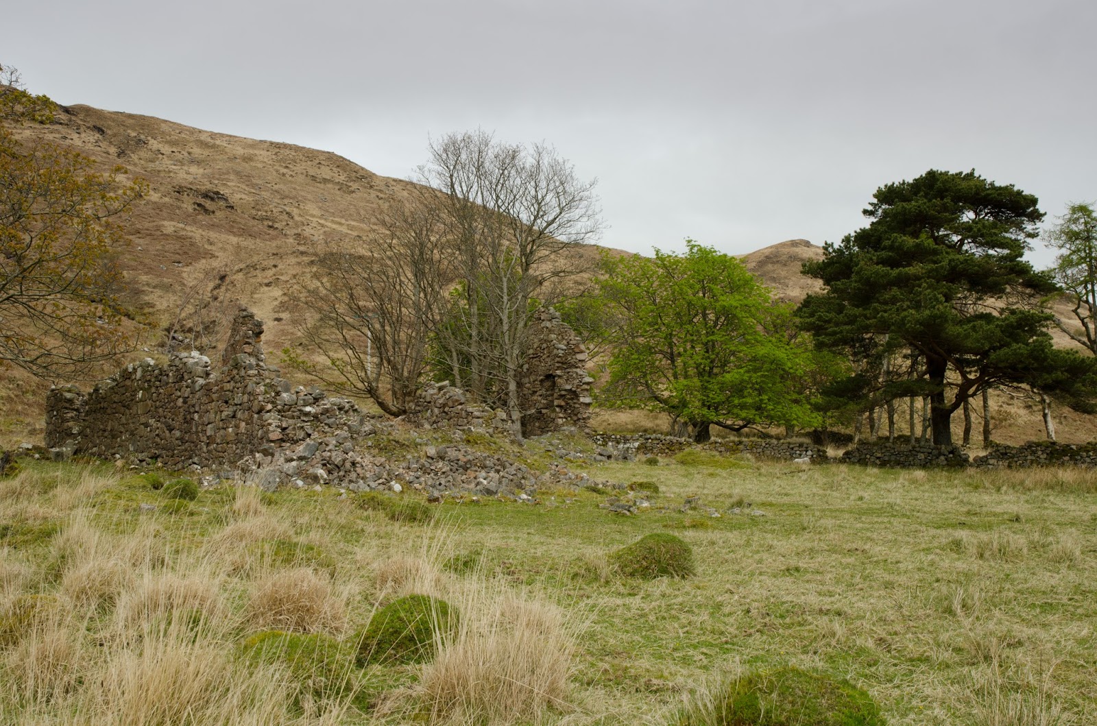
A few kilometres further on we stopped to take a walk around Arigh Shamraidh (the summer shieling). Visible from across the loch as a green patch lined by trees, there are five ruined buildings and a field system here, the ruins probably date to the early 18th century but earlier maps how a permanent settlement of similar size.
Further along again we passed Camasnacroise (Bay of the cross) with its neatly painted white houses and church on the shore of Loch a' Coire. The church-related names include the hill which towers over the shore - Beinn na Cille (hill of the (monks) cell) In 1890 the village is recorded as having a church, school, shop and smiddy. The village is quite remote by modern standards, and connected by tiny single track roads.
We enjoyed paddling the wild shore north of Camasnacroise, moving slowly and absorbing the atmosphere of the place. A couple of potential camping spots came and went before we found a place on a level grassy platform above the shore. The effort of carrying all our stuff up a steep 20 metre slope was rewarded with a view across Loch Linnhe to Cuil, from where we'd set out.
We could easily have crossed back and ended the trip without camping, but elected to spend another night out and have a short paddle the following morning.
We spent a pleasant evening enjoying the views from our camp, though the morning turned out damp with some drizzle and a thick mist. I took some bearings and set up a route on my GPS as we packed the boats, as well as putting the VHF radios to "scan" in order to pick up any traffic from vessels moving on the loch which we'd not be able to see.
After travelling up the shore a little way we struck out across Loch Linnhe towards Cuil just as the drizzle stopped and the mist began to break into banks of low cloud. With such damp, low-light conditions and little wind, we were thankful that the midges hadn't got going by this time in April!
All too soon we were back at Cuil in a rapidly improving morning with a fresh breeze dispersing the last of the cloud.
Our two night trip had been relatively short in distance at just over 50Km, but had been really relaxing as we'd deliberately kept our plans to the minimum and just gone with the flow. It had also been a useful shake-out of our kayak camping kit, which had shown up a couple of deficiencies and necessary tweaks before a longer trip.
Friday, 19 May 2017
Cuil camping
This the first of two catch-up posts from a camping trip Allan and I made on Loch Linnhe in the second half of April. The plan was for a relaxed circuit and a couple of nights wild camping; for both of us it was the first overnight trip of the year due to work or health reasons. A bigger trip was in the planning so this would also be a good shake-out of camping kit.
Our starting point was Cuil Bay on the eastern shore of Loch Linnhe, where a couple of cars can be parked by the side of the minor road above the shore - taking care to leave access for farm vehicles. Cuil translates as either "wing" or "back", both of which would be good descriptions for the shape of the bay.
The weather looked good with sunshine and cloud dappling the long view down the loch towards the distant Mull hills.
We paddled south down the loch in perfect conditions, enjoying the reflections of the Morvern hills on the mirror calm water. To our left the main A828 road follows the shore for several kilometres and there was some traffic noise, but this soon fades when the road turns inland a little.
We took luncheon on a tiny pebble beach at the north tip of Shuna (the northerly of two islands with the same name in this area, the other being in the Firth of Lorn). The sunlight was picking out the colours of the pebbles below the water beautifully - it really was a very relaxing spot. Looking over the loch to Morvern, I recalled one of our trips from the previous year when we'd paddled around Movern in late summer warmth. Loch Linnhe seems to be overlooked a bit by sea kayakers, but it does have the potential for good trips.
After paddling around the outside of Shuna, our next stop was at the ferry jetty on Lismore. There's a toilet and water from a tap at the ferry waiting room here, handy on longer trips. We now had a decision to make....our plan was very flexible and we'd not planned in any more detail than a starting point and a basic direction down the loch. From the jetty we could paddle down either side of the island of Lismore (Lios Mor - the big garden, so named for the fertility of the island which is on limestone).
We chose to go down the outside, west, side of the island as it has plenty of interest and a few more camping options. Within 30 minutes of setting out, a stiff NW'ly breeze blew up and made things quite bouncy - it seemed we'd made the wrong choice!
A considerable chop built up as we passed beneath the ruin of Castle Coeffin. Built in the 13th century by the MacDougalls of Lorn, the castle passed into ownership of Clan Stewart through marriage and eventually to Clan Campbell.
We were glad of the opportunity to tuck into the bay below the castle for a breather out of the wind. This bay must have been a factor in the siting of the castle as the MacDougalls were a clan of sea raiders, the beach must have been a perfect base for operating the highland version of a longship - the Birlinn.
The bay also contains the well-preserved remains of a medieval fish trap. The fish were held back as the tide dropped and could be caught easily in the confines of the trap.
We considered making our first camp on the cropped turf below the castle, but a reasonably polite notice asks that folk don't camp here as it's close to the croft house and is grazed occasionally by horses. We had a quick look at the map and decided to backtrack on our route a bit to a spot we'd noticed earlier.
It was a fairly stiff paddle back up against a strengthening wind to reach the spot we had in mind, but it was worthwhile as it was a good place to camp with a little shelter from what had become a cold NW'ly wind - a "Cuil" breeze in fact!
After dinner we managed to find a spot for a campfire below the high water line and enjoyed a dram or two to mark the first kayak camp of the year.
Sunday, 9 October 2016
How to remove a hill - one load at a time
We paddled on down the Morvern coast past Loch a'Choire and took a short break for first luncheon on a beach of pale pink granite pebbles.
The shoreline here drops steeply into Loch Linnhe and feels quite wild, until.........
...a corner is turned and the landscape is instantly industrial. Glensanda quarry is, quite simply staggering. The operators, Aggregate Industries describe it as a "superquarry" and it really is that, in every sense of the term.
A few statistics:
Glensanda produces ten million tonnes of crushed granite each year. There are estimated to be 760 million tonnes of rock still to be quarried. The rock is quarried from the mountain 600m above the shore and the super-sized hole is masked by leaving the face intact, thus minimising visual intrusion. A 1.8km conveyor grades and washes the quarried stones, placing them into a pile of up to half a million tonnes, where the aggregate can be washed and further graded.
Whatever your view of the environmental pros and cons, Glensanda is impressive. Of course, having quarried all this aggregate, you need something big to put it into.....
...and this is it. MV Yeoman Bridge at 200m long, 38m beam and drawing some 15m is a very big ship. Her size is matched by an impressive capability - she is able to carry 97,000 tonnes of aggregate at a time and has a self-discharging capability of 6000 tonnes per hour. The granite she carries is so hard that her holds need a very specialist coating to withstand the abrasion of loading and unloading. In service since 2006, she's carried some 35 million tonnes of granite away from Loch Linnhe so far.
Yeoman Bridge's bow gives a hint of just how big she really is when seen close up from the water.....
....and paddling past her was like travelling alongside a red wall.
The granite from Glensanda is used across the UK and Europe - some recent projects such as motorways in Poland, ballast for a high speed rail link in southern France, the Elbe tunnel in Hamburg, the Channel Tunnel and a new port on the Thames are detailed in the quarry brochure.
Just past the heavy industrial landscape of the quarry, the ruin of the 15th century Glensanda Castle is a more traditional use of the local granite. A one-time MacLean stronghold, Glensanda looks out over Loch Linnhe and almost seems to have its back to the quarry.
Slowly, as the quarry receded behind us the scene returned to something more natural, and as we turned another corner....
.....the quarry and deepwater facility were no longer visible - just the view back up Loch Linnhe. The process of removing a whole hillside one shipload at a time is never going to be either gentle or unobtrusive, but I'm guessing that few people guess the true scale of Glensanda, or even know it's there at all as little is visible from across the loch.
Thursday, 6 October 2016
Not quite an island... not quite the mainland
Morvern isn't quite an island, though it has the feel of being one. Shaped roughly like an inverted triangle, it's almost surrounded by water with Loch Linnhe to the east, the Sound of Mull to the south west and Loch Sunart moating the majority of the northern flank. Only at the north eastern corner is the peninsula attached to Ardgour, itself almost surrounded by water, by the 11 kilometre Glen Tarbert (from old Norse and meaning "draw boat"- an indication that boats could be portaged between bodies of water)
Adding to the island feel is the fact that the simplest access is by ferry from Lochaber. I've paddled most of the Morvern coast but not previously done the journey around the peninsula as an "integrale" trip. A rather changeable forecast had prevented Douglas and I planning anything exposed to wind and swell, but we thought that the general easterly airflow might suit this trip. Douglas has done the route previously and really enjoyed it, which is recommendation enough! We were delighted that our friends Mike, Phil, Donald and David could join us, and quite by chance I met Ronnie in the ferry queue - he was on a separate trip but could meet us for one night of the journey.
We met up at Inversanda Bay on a rather drizzly mid-August morning and carried our boats down to the beach. Inversanda should indicate that this is the mouth of Glen Sanda, but curiously, it's actually the eastern end of Glen Tarbert and where the River Tarbert enters Loch Linnhe. It's possible to park a couple of cars off the road here, but care needs to be taken not to block the farm track.
We shuttled a car over to our planned finishing point of Strontian at the western end of Glen Tarbert and were ready for the off.......
For all except a short stretch, no road goes down the Loch Linnhe side of Morvern and there's an immediate feeling of a wild coast. A long and wide sea loch, Linnhe has much to offer the sea kayaker and seems relatively overlooked.
A bonus was that the drizzle ceased and the cloud began to clear away. We began to warm up in our waterproofs, so a second breakfast stop seemed in order.....
....where we removed waterproof jackets to the delight of the waiting midges, not entirely unexpectedly! Donald could at least get offshore in his F-RIB and create his own breeze, the rest of us had to put a spurt on once back on the water to leave the little blighters behind.
A little further down the coast, I spotted a stone building tucked into the hillside above the shore. An investigation seemed worthwhile, so Douglas and I climbed up the grassy slope to take a look.
The building proved to be "Pirates Store", a bothy belonging to the nearby Abernethy Trust centre at Kilmalieu. The Trust is a Christian organisation which provides outdoor adventures and has bases around Scotland. Inside the bothy is a notice welcoming visitors and asking that the place be left tidy - in effect the same principles as the MBA Bothy Code, though Kilmalieu is privately owned.
The others had paddled steadily on ahead while we looked at the bothy, and we caught up with them a little further on......
Adding to the island feel is the fact that the simplest access is by ferry from Lochaber. I've paddled most of the Morvern coast but not previously done the journey around the peninsula as an "integrale" trip. A rather changeable forecast had prevented Douglas and I planning anything exposed to wind and swell, but we thought that the general easterly airflow might suit this trip. Douglas has done the route previously and really enjoyed it, which is recommendation enough! We were delighted that our friends Mike, Phil, Donald and David could join us, and quite by chance I met Ronnie in the ferry queue - he was on a separate trip but could meet us for one night of the journey.
We met up at Inversanda Bay on a rather drizzly mid-August morning and carried our boats down to the beach. Inversanda should indicate that this is the mouth of Glen Sanda, but curiously, it's actually the eastern end of Glen Tarbert and where the River Tarbert enters Loch Linnhe. It's possible to park a couple of cars off the road here, but care needs to be taken not to block the farm track.
We shuttled a car over to our planned finishing point of Strontian at the western end of Glen Tarbert and were ready for the off.......
...wasting no time in getting underway as our first day would be quite a long one.
For all except a short stretch, no road goes down the Loch Linnhe side of Morvern and there's an immediate feeling of a wild coast. A long and wide sea loch, Linnhe has much to offer the sea kayaker and seems relatively overlooked.
A bonus was that the drizzle ceased and the cloud began to clear away. We began to warm up in our waterproofs, so a second breakfast stop seemed in order.....
....where we removed waterproof jackets to the delight of the waiting midges, not entirely unexpectedly! Donald could at least get offshore in his F-RIB and create his own breeze, the rest of us had to put a spurt on once back on the water to leave the little blighters behind.
A little further down the coast, I spotted a stone building tucked into the hillside above the shore. An investigation seemed worthwhile, so Douglas and I climbed up the grassy slope to take a look.
The building proved to be "Pirates Store", a bothy belonging to the nearby Abernethy Trust centre at Kilmalieu. The Trust is a Christian organisation which provides outdoor adventures and has bases around Scotland. Inside the bothy is a notice welcoming visitors and asking that the place be left tidy - in effect the same principles as the MBA Bothy Code, though Kilmalieu is privately owned.
The others had paddled steadily on ahead while we looked at the bothy, and we caught up with them a little further on......
....where they were waiting on a shingle beach below wooded slopes. The scenery here is wild, with the only man-made elements a tiny road and a line of power lines squeezed hard against the shore , but to the south of here we knew that there was perhaps one of the most incongruous sights on any sea loch.
Wednesday, 18 February 2015
In the bleak midwinter - lime and coda
From Castle Stalker we used the sails to speed our passage across to Shuna Island. There's another island called Shuna, somewhat further south at the mouth of Loch Melfort, but the one we were headed for is the Loch Linnhe version. We paddled up the west side until we found a fine place for luncheon on a small sandy beach at the head of a bay and sheltered from the wind.
After a leisurely lunch stop we headed around the north tip of Shuna and straight into a stiff southeasterly breeze. It requred a reasonable amount of effort to push against both the wind and the start of the flood tide, but ahead of us was a great view down the Lynn of Lorn to the Garvellachs, the scene lit by occasional shafts of watery winter sunlight.
After circumnavigating Shuna we continued south and made our way to Eilean nan Caorach (Sheep Island) where we landed in front of the cottages and industrial relics. The base rock heareabouts is lime-rich and was quarried quite extensively. the cottages would have been occupied by the quarrymen and lime-burners, there is a storehouse, a pier and three single-chamber lime kilns, all of differing designs.
The smallest of the three kilns appears to be the oldest and is in a fairly ruinous state. given the extensive cracks down the walls we were disinclined to venture within!
The largest of the three may well be the most recent and is in a sound condition. The rock was quarried and in this style of kiln would have been broken to lumps and layered with coal or coke on a raised grate. The size of the lumps was important because the fire had to "breathe". The fire would be lit and at approximately 900 degrees Celcius a chemical reaction (calcination) initiated and quicklime produced which could be raked through the grate.
Most lime kilns are of a very similar size as a result of optimisation. The aperture was known as the "eye" and the chamber is almost always eggcup shaped. Usually a batch took a day to load, three days to fire, two days to cool and a day to unload. Typically 25-30 tonnes of lime would be produced in a batch, requiring about 12-15 tonnes of coal to fuel the fire. The quicklime which was produced was quite caustic but could be altered to make lime for mortar and for agricultural use. It must have been hot, dangerous work and it's difficult to believe that life expectancy was very high for the workers. The kilns on Eilean nan Caorach and nearby Lismore were active from the 1790's until well through the 1800's.
From above, the size of the flue is obvious.......
...and from inside the burning chamber the inticate brickwork is seen to good effect; a fine Victorian engineering job.
We moved on from Eilean nan Caorach a little further south, to Port Ramsay at the north tip of Lismore (Lios Mor - big garden) No doubt the gaelic name is indicative of the fertility of this limestone-rich island.
We made a brief coffee stop on one of the small tidal islands clustered just off Port ramsay and enjoyed the view back over Eilean nan Caorach and Shuna to the Appin shore. Our midwinter trip was almost over, but we had one last treat in store....
Heading out past the north tip of Lismore we were exposed to the full force of the flood tide as it compressed through the north end of the Lynn of Lorn. We had to PLF for a good ten minutes to get around the small skerries and then set up for a ferry-glide back to Port Appin; it certainly rewarmed us!
To the south, a vivid streak of sunset colour beyond the Garvellachs developed across the horizon, providing the perfect coda to a great winter trip.
It hadn't turned out to be a bleak midwinter at all!
Tuesday, 17 February 2015
In the bleak midwinter - red blood, grey stone and a pink with yellow spots lighthouse...
For the final day of our midwinter trip we decided on a shorter paddle, starting at Port Appin. We would head north to Castle Stalker before circumnavigating Shuna Island. We also hoped to visit some of the smaller islands off the north end of Lismore.
This area is justifiably popular for sea kayaking as it packs history, wildlife, numerous islands and a bit of tidal flow into a small area. Having said that, we once again saw more Sea Eagles and Otters than other kayakers !
The trip can be done from a long layby at Polanach on the A828 road but we chose Port Appin as our starting point. There is parking here just across the road from the jetty which services Lismore, but in summer it can be difficult to find space to park. Traditionally the ferry port for Lismore, Port Appin was once a busy steamer port and more recently was the main crossing point for workers at the huge Glensanda granite quarry across Loch Linnhe
We set out northwards against the last of the ebb tide and soon passed the small lighthouse on Sgeir Bhuidhe (yellow skerry - probably named due to the bright yellow lichen which grows on the rocks). The first light tower here was a 7 metre high iron tower on a brick base designed by David Alan Stevenson in 1903 and powered by acetylene. It marked the passage from Shuna Island into the Lynn of Lorn and exhibited a white flash with a red sector once every six seconds, visible for up to nine nautical miles.
In 2000 plans were drawn up to dismantle the old light and replace it with a steel tower with white aluminium panels to a simple but souless design. A local campaign was started to preserve the style of the light which gained wide publicity when the entire existing structure was painted pink with yellow spots in 2001. Officials at the Northern Lighthouse Board were less than amused, but some good did come of the prank because the plans were revisited and a fibreglass tower more in keeping with the traditional design replaced the old light in 2002, powered by solar panels. The original lantern is on display in Port Appin village together with an information board.
We hoisted sails in the freshening breeze and in no time were arriving below the somewhat older landmark of the iconic 13th century Castle Stalker (Stalcaire - hunter (falconer)). Built on a rocky outcrop at the mouth of Loch Laich it is surrounded by water except at very low tides when mud and sand would have anyway slowed down any assault. As with many of the castles in the area it belonged to the MacDougalls of Lorn, a half-norse pirate clan who based their power on control of the sea and on their Birlinns - fast, light ships which could be rowed or sailed and were based on Norse longship designs.
The especially bloody history of the castle is well told on the Castle Stalker website, starting with a murder in 1463, and continuing in a litany of bloodshed until a final unfortunate killing as recently as 1949 when the then owner Duncan Stewart was stabbed in Sarawak; he died a week later. The castle was purchased by the late Lt Col D.R. Stewart Allward in 1965 and restored by his and his family's labour to a fully habitable state - a quite remarkable achievement. Some images of the interior of the castle are contained in the "Canmore" archives.
Castle Stalker is one of the iconic images of this part of Scotland, and has also been etched into popular culture by appearing as "Castle Aaaaarghh" in the film "Monty Python and the Holy Grail", notably when King Arthur is taunted from the walls by a defender with an outrageous French accent......
The building is well seen from the road above Loch Laich, but close up the details come alive. Above the door is a carved coat of arms, heavily weathered but appearing to bear a figure in the centre.
The thin breeze was getting quite chilly so we finished our exploration of the outside of the castle and the island and headed back down to get moving under sail in our own versions of Birlinns!
Subscribe to:
Posts (Atom)


