Showing posts with label history. Show all posts

Monday, 13 May 2024

Happy returns in Morar

The first few months of 2024 have seen some really poor weather conditions in Scotland.  In the north-east of the country it was the wettest winter for many years and April was the coldest since 1905!  When the forecast for the first few days of May showed warm and settled conditions on the west coast, Douglas and I made plans for a few days sea kayak camping.

We met at Mallaig mid-morning on a glorious day.  A glance at the map shows how well positioned Mallaig is to access superb sea kayaking routes.  Our plan would be very flexible and would largely be dictated by a forecast of variable winds from a generally easterly direction.  Before packing our boats we took second breakfast of croissants and pains au chocolate with coffee from the excellent Mallaig Bakehouse and also bought a large focaccia bread to accompany dinner.


 We were on the water and away shortly after noon and enjoyed a leisurely few hours paddle towards our first planned camp.  As we'd both had long-ish drives to reach Mallaig we had no intention of pushing hard to make distance, it just wasn't that sort of a day.  A light breeze from astern helped push us gently along as we paddle-sailed a shoreline alive with the sounds of Willow Warblers and echoing to the calls of Cuckoos.


Arriving at a camp we've used before is a bit like meeting an old friend; one looks for the subtle changes and reminisces about good times.  We were pleased to see not much had changed here and that the bracken hadn't started reaching up, making for a better range of pitches.  We got our tents up, enjoyed a coffee and then went for a walk.  Douglas and I both enjoy the off-water parts of a sea kayak trip as much as the paddling, exploring and just being in a place adds so much to the experience.


We climbed above the shore and through woods of birch and oak to a stretch of higher ground which had clear signs that this now deserted shore was once worked by a community.  "Run Rig" furrow marks were everywhere, testament to back-breaking work over generations to make something of the poor, acid soils by fertilising with seaweed and dung.


Croft houses, some little more than a gable or a "rickle o'stanes" dot the ground near the shore.  It's likely that the occupants had been moved from better agricultural ground inland to theses far edges to make way for sheep in the years of the Clearances.  The houses had a superb situation, but a view won't feed your family and this was subsistence living at the extreme with starvation an ever-present threat.


Near the ruins of a more substantial house was this tractor which is slowly being consumed by rust and the boggy ground.  We could make out that the engine was a Standard make, but little else - it would be fascinating to learn something of its story.

Just around here we were treated to one of the experiences which really make a trip.  Overhead we heard the distinctive "kyow-kyow" call of a White Tailed Eagle.  looking up we saw not one but two birds flying purposefully overhead.  But things got even better; a third, absolutely huge eagle (an adult female we think) launched from a nearby crag and engaged the two overflying birds.  Twisting in mid-air and presenting its talons seemed to intimidate the two birds which flew quickly off.  Then the third bird was harried relentlessly by a pair of Ravens which mobbed it all the way back to the crag - it was a great wildlife spectacle!


It was only four or so hours into our trip but already it felt that we'd been amply rewarded for making the effort to get out!  Returning to our camp we gathered driftwood and some fallen birch branches for a fire and started to think about getting dinner prepared....

Wednesday, 31 January 2024

Winter colours - Wester Ross

On the second paddling day of our trip in Wester Ross Allan and I launched from the jetty at Laide in Gruinard Bay.  This is a handy launch spot but there's virtually no parking at the jetty itself so we parked back up the road a way so as not to block things for any other users.  There's also an honesty box, ingeniously adapted from an old fire extinguisher, for donations towards the jetty's upkeep.

It was another very cold, clear and calm morning - "frost smoke" was rising from the sea as the sun climbed a bit higher.


We paddled around the inner part of Gruinard Bay and landed at the northern end of the big beach which is so popular in summer.  Today we had it to ourselves for a leisurely coffee break.


Heading north we had a view to Priest Island and the Summer Isles, we've had some great paddling ventures there!  Conditions were near perfect and we landed at Mungasdale Bay for a second stop - not sure whether that was third breakfast or first luncheon though.....


From Mungasdale we paddled over to land on the boulder spit at the south of Gruinard Island, infamous for the experiment that was carried out here to test the efficacy of a biological weapon.  The desparate measures under consideration during WW2 are understandable, but not the indifference of the UK government for decades afterward - they were eventually forced to properly (hopefully!) decontaminate the whole island in 1990.  The disconnect between a remote UK government and the north of Scotland is neatly illustrated in the staged image at the end of the BBC news article linked above with a Defence Minister pulling down the "Landing Prohibited" sign....dressed in a pinstripe city suit and immaculate dress shoes.

We stopped but briefly on the bouldery spit - it's hard on the feet in paddling footwear.  Interestingly the island has been recently and intensively planted with forestry, so clearly there is confidence that disturbing the soil won't release any dormant anthrax spores.  Behind Allan in this image, the brilliant white summits of  An Teallach rose into a blue sky .


The view across to Torridon when we arrived back in Laide was glorious - winter can sometimes throw up the most stunning conditions.


Back at our base on Loch Ewe the last of the sun lit the Fisherfield hills s we enjoyed a post-paddle cup of tea, but the best of the colour was reserved for well after the sun had set.....


 ....as the sky and sea suffused with the most intense and beautiful lilac pink light.  Some winter days are just so perfect!

Tuesday, 20 September 2022

Pinned on Pabay

The morning weather was as lovely as the evening had been, clear and calm.  The view to the Cuillin of Skye was our constant companion on this trip and one of the highlights with changing light and angles subtly altering the colour and form.  We've all got great memories of climbs on that great arc of ridge - exhilarating and sometimes downright frightening!


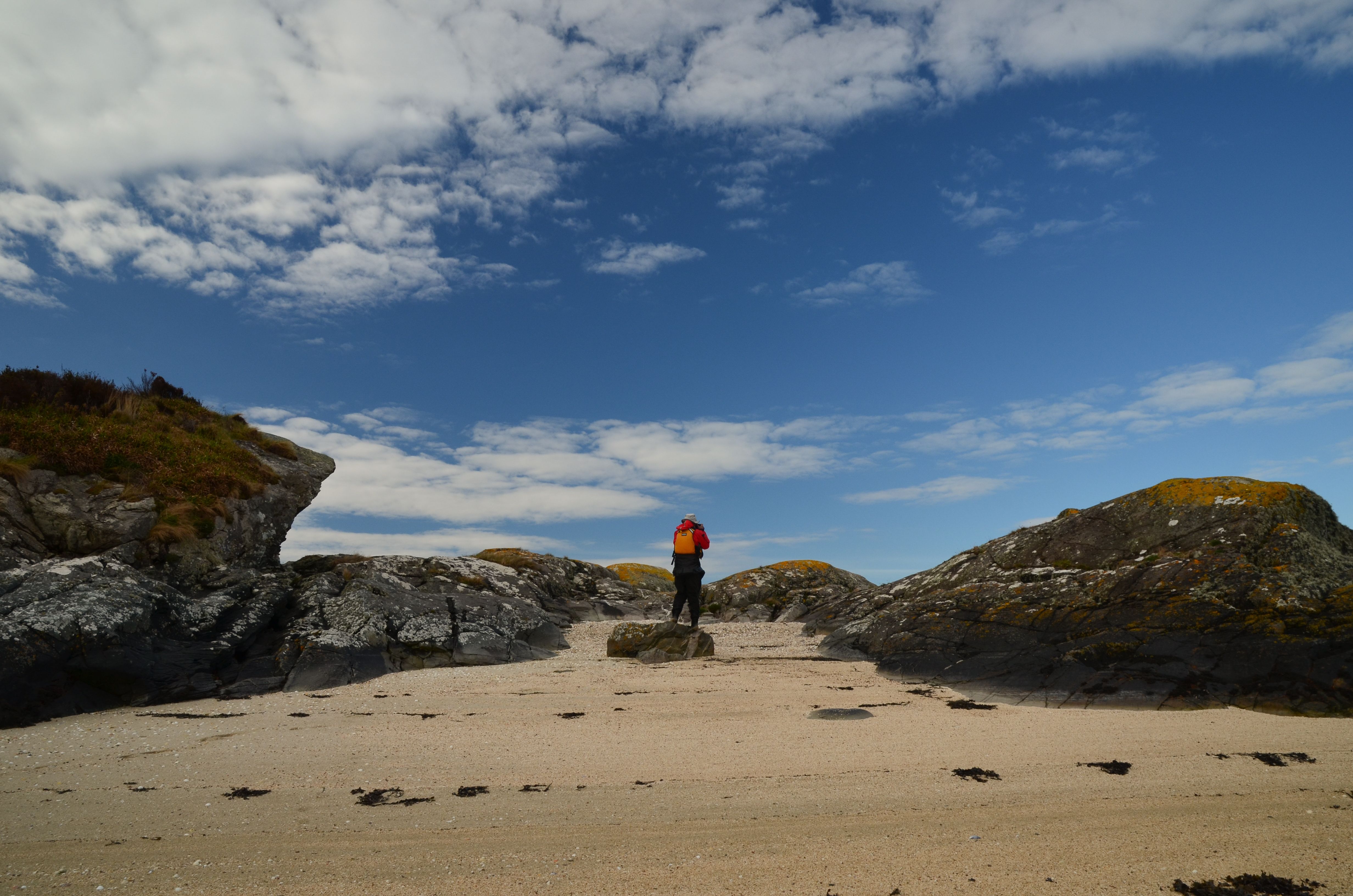
We had a leisurely breakfast and got on the water - within a few minutes we were back ashore on a tiny island with a "now you see it, now you don't" sandy beach which disappears at higher states of the tide.  We'd wanted to stop here because it's rather a fine viewpoint; the first image in this post was taken from the beach.


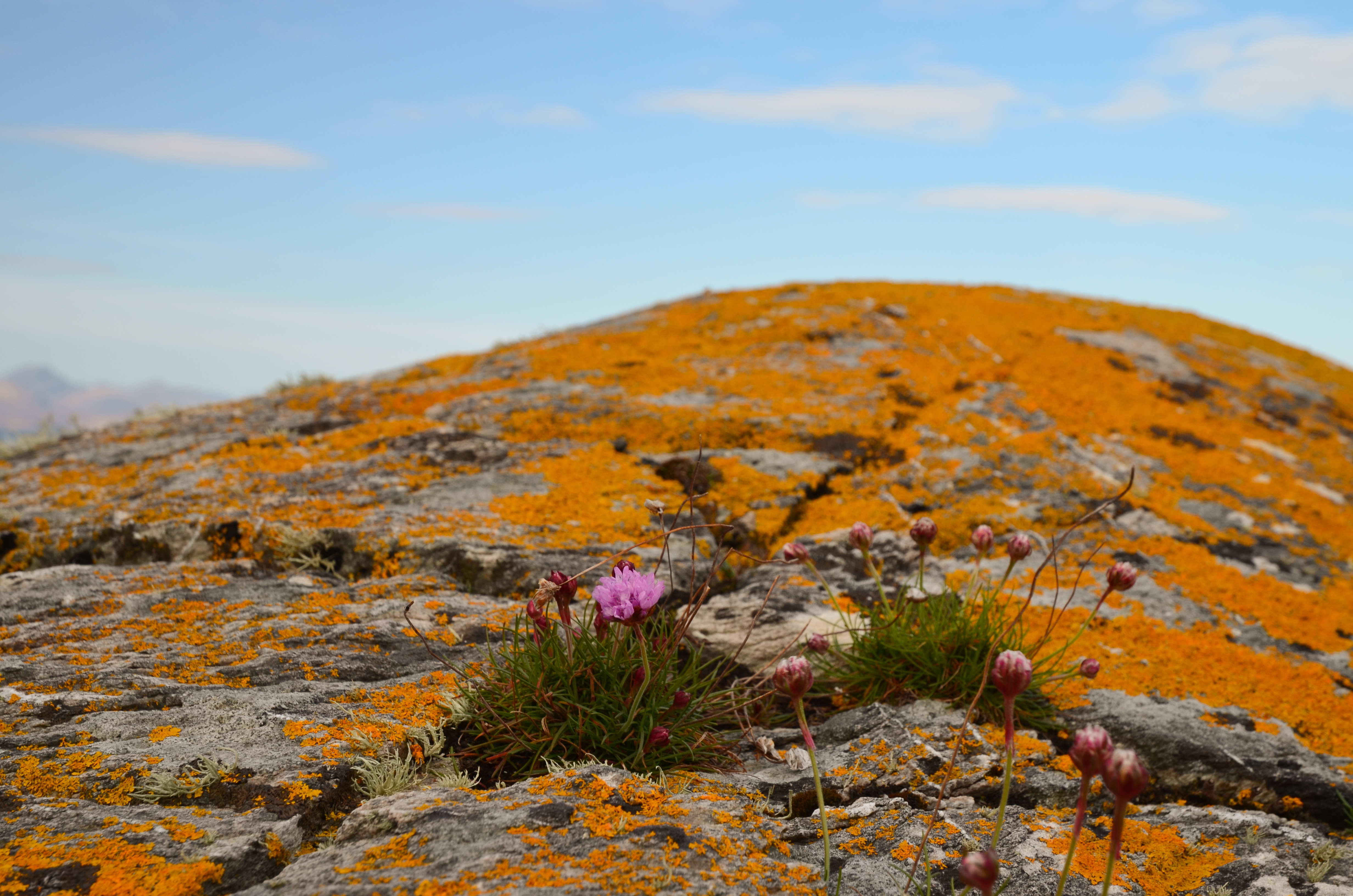
The view near to hand wasn't bad either - vivid orange lichens glowing in the morning sunshine, set off by a few Thrift flowers.


Orange seemed to be the theme of the morning; we returned briefly to Kyleakin to collect some things and whilst preparing to get back underway we noticed a bright orange vessel passing under the Skye bridge.


She's the "Mikal With", a 67 metre long palletised cargo vessel.  On most marine vessel websites she has a blue hull and a different owner than recently.  She's either owned or on charter to MOWI, a Norwegian aquaculture company.


We set out again from Kyleakin and aimed for the island of Pabay, which we intended to use as a stepping stone on our way to an intended camp on Scalpay.  The breeze had been slowly building and once clear of Kyle Akin it became quite strong from straight off the Skye coast (our port quarter).

We put our sails up to take advantage of the push and were absolutely blasted across towards Pabay.  I found this a really great sailing run, but was certainly not prepared to stop paddling in order to take photos!  Our average speed on this blast was 9.4km/h, or nearly twice cruising speed.....


Although a fast passage, it had been an energetic one - it is paddle sailing rather than just sailing!  We were all ready for a lunch stop by this point.


Approaching Pabay the wind seemed to ease  a little and we dropped our sails to paddle into the tiny harbour area.  Donny had motored along to Broadford in his F-RIB and made a direct crossing from there to Pabay; he had a pretty wet ride!


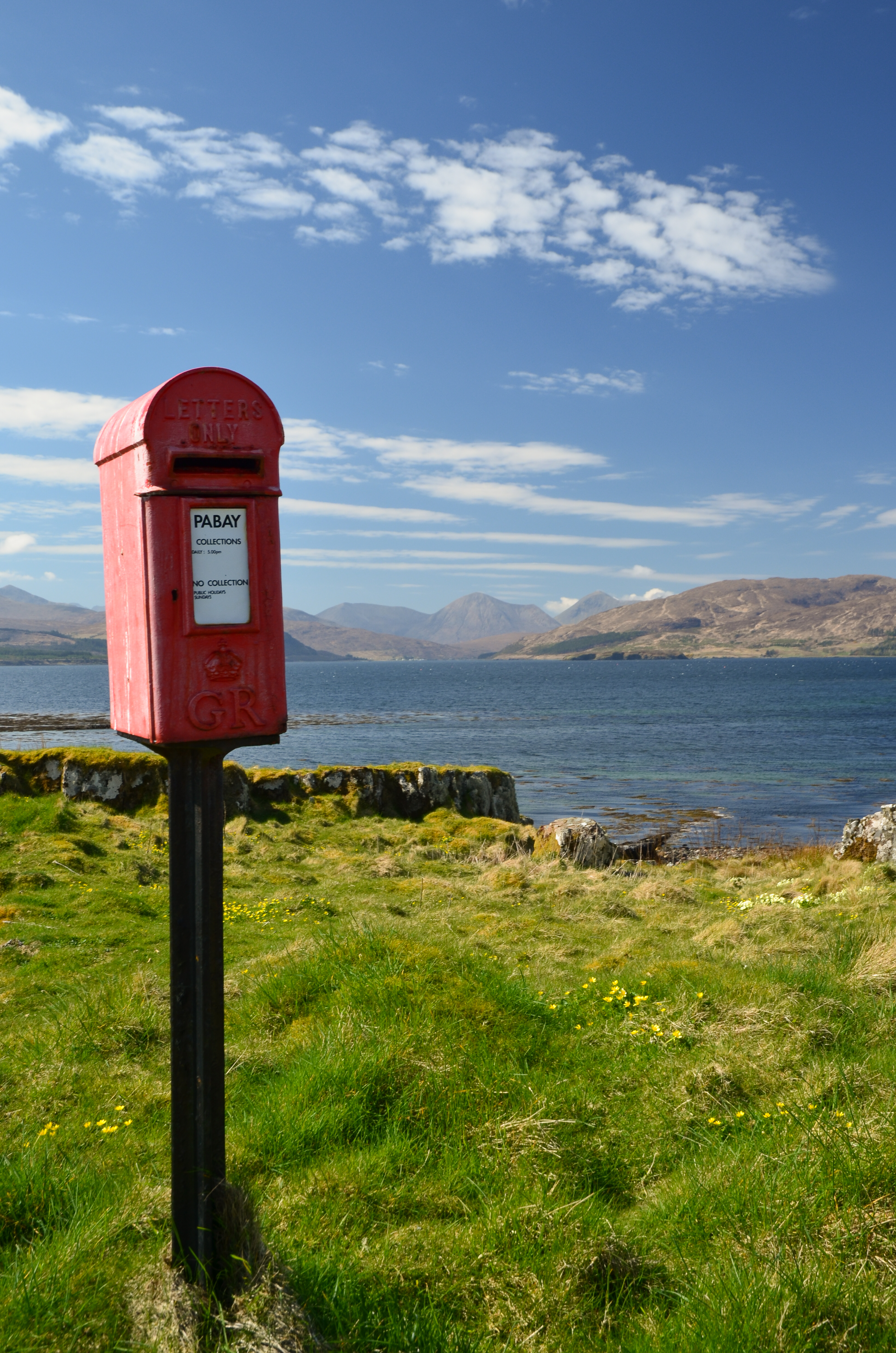
One of the iconic sights on Pabay (Norse: Priest Island) is this post box.  It seems incongruous since there are only a couple of houses on the island but is here because the island issues it's own postage stamps for mail which is transferred into the Royal Mail system in Skye (from where it needs Royal Mail stamps).


Sheltered from the breeze (which was becoming stronger) we lazed in warm sunshine, surrounded by clumps of Primroses.  The pale yellow of the flowers set against the blue of sky and sea was gorgeous.


Above where we lunched a pair of Bonxies (Great Skuas) watched us warily.  These impressive piratical predators had picked a nest site with a great view over the low lying island.


One of the features of Pabay is its geology which is shales intersected by dykes of harder rocks.  The whole island is almost flat and nearly doubles in size as the tide falls from high to low water, leaving the geometric patterns of dykes.

Another feature is that, despite being flat the island has virtually no wild camping spots accessible from the water.  The rock layers from a barrier and the softer rock gives good growing conditions for brambles and tangled low undergrowth.

This gave us a problem; we were pretty much pinned on Pabay.  The wind had continued to rise and in the Sound between Pabay and Scalpay was approaching a Force 6.  None of us was keen on trying the paddle across unless we really had to, but despite trying along the sheltered parts of Pabay by kayak we could find nowhere to camp.  We returned to the harbour to have a re-think.  Douglas and I walked up to the "big house" which is undergoing renovation by a new owner of the island.  We explained our situation and asked if we might camp near the harbour.  The Access provision in the Land Reform (Scotland) Act is wide ranging but does not cover access near to houses or infrastructure.  The owner was most kind in allowing us to camp for the night and it was really appreciated by us.


We pitched our tents in areas which wouldn't affect access to and from the harbour itself and found a spot out of the wind to cook dinner - preceded by fresh soup.  The day had been recovered but our plans would need to be altered.  The forecast was for the wind to drop almost completely by morning, so we decided on a paddle to the Applecross shore via the Crowlin Islands.


As the sun set, the wind came around a couple of points and seemed to drop by several degrees in temperature - it was pretty cold within minutes.  Dinner done, we retired to the tents (which we'd pinned very securely to Pabay) for an early night.
 

Wednesday, 25 May 2022

Bridging the gap

This is a catch-up post from a walk in upper Donside in the second half of April.  Lorna, Allan and I have explored many of the area's tracks, especially when Covid restrictions limited the distance we could travel.

We decided on a linear walk from Corgarff at the foot of the Lecht road down to Bellabeg in Strathdon.  By the A944 road this isn't a particularly long route but we intended to use parts of altogether older roads.  We would also link a series of bridges which have historical interest - the "bridge" theme would continue in that our route would bridge a gap between walking routes we know well.


We set off on a lovely Spring morning, heading SE from Ordgarff along the track which is signed as "Old Military Road".  This simple statement has a deal of history behind it because this is a section of road built between 1748 and 1757 as part of  a massive roadbuilding and infrastructure project following the 18th century Jacobite rebellions.

That said, the first of the bridges isn't typical of the "Wade Bridge", being a graceful, slender arch over the Allt Damh - seemingly defying gravity! 


Just under 2km further along the track is Delavine Bridge.  This is much more representative of the bridge construction on the 18th century military roads.  Delavine was one of three bridges repaired and stabilised over three years from 1997 to 2000 to keep these scheduled monuments intact.  A plaque on Delavine bridge records the work, placed on the outer parapet where it is particularly difficult to read without standing in the burn itself!  It is typical of the larger bridges of the period in construction and in being 4 metres wide.

The familiar term is "Wade roads" and "Wade Bridges" in reference to General George Wade, a military Commander in North Britain from 1724 to 1740.  Wade is actually the only person named in the British National Anthem - one of the more clunky verses which isn't used today reads:

"Lord grant that Marshal Wade
may by thy aid victory bring
May he sedition hush
And like a torrent rush
Rebellious Scots to crush
God Save the King"

The "Wade" road here is part of a 100 mile (160km) route from Coupar Angus to Fort George near Inverness via Braemar, Corgarff and Grantown on Spey.  The whole route was built in nine years between 1748 and 1757, starting just two years after the final Jacobite defeat at Culloden Moor.  For context, the 26 mile/42km Aberdeen Western Peripheral route took five years to complete in the 21st century!

By the time construction of this road was started Wade had long since left the Highlands and in fact died in the same year work on this route started.  His successor, Major William Caulfeild (note the spelling, not "Caulfield") was appointed Inspector for Roads in Scotland in 1732.  While nowhere near as well known as Wade, Caulfeild oversaw far more of the network: Wade was responsible for 250 miles (400km) of road, forty bridges and two forts; Caulfeild  for 900 miles (1400km) of road and over six hundred bridges - an astonishing series of works.   

The road we now walked is part of the longest single stretch Caulfeild built at 100 miles and the line it took was clearly good because the vast majority of the route is still public road, suitably upgraded for modern traffic. This stretch wasn't absorbed into the road network and remains as a great walking route. 

The ingenuity, effort, endurance and craft of the road planners and of the regiments of soldier-navvies who constructed the military road network is a great testament to one of Britain's greatest engineering feats. 


A little over a kilometre further on the road crosses the third bridge of the section, this one spanning the Burn of Tornahaish.  Here also the bridge required restoration works and all three bridges on the section are now leased from the landowner, Candacraig Estate, by the Gordon Trust on a 99 year lease.  Smaller than Delavine and without a parapet, the span and height above what is a very small burn gives an indication of the volume the Burn of Tornahaish is capable of in spate.


The track climbs up from Burn of Tornahaish to join the A939 road, or more properly become the A939 road.  From here the Military Road goes to Gairnshiel then on over the hill to Crathie on Deeside.  We walked uphill for a short way before leaving the road on a track cutting back uphill, having bridged the gap of several kilometres between our previous walks.  Here we had a choice of routes to reach Bellabeg.  One route would take us over to link with a lower level walk we've done before while the other would climb up onto the high ground to cross the summit of Scraulac - a route done several times previously.


We chose the higher level option as the weather was good and we were in no particular rush.  The summit of Scraulac (which I think may be from the Gaelic for Scree Place) is really wide, though today a bit breezy too.  An estate worker passed us on a quad bike here and was the only other person we saw on the entire route.

We left the estate tracks to descend Scraulac's north east ridge, finding a remarkable hidden building en route.  A good track which became a metalled road soon led us down to the public road at Culfork.  This really is a "road less travelled", a loop of minor road running parallel to the A944 but on the opposite side of the river Don.  A relatively new venture along here is Cairngorms Glamping and Camp Site, which looks to be a super place to spend a holiday!


 Cutting off the road just outside Bellabeg, a track descends around a wooded hill to the last of the historic bridges of our walk.  Poldullie Bridge was constructed in 1715 by Sir John Forbes of Inverernan and crosses the River Don. A remarkably graceful single span bridge, the elegant form is best seen from above as in the images on the Canmore site.  Sir John Forbes made a fatal choice in throwing in his lot with the Jacobites at the 1715 rebellion and was captured following the battle of Sherrifmuir.  He died in Carlisle prison the day before the date of his execution.  It was this rebellion which prompted much of the roadbuilding effort in Scotland in order to "pacify" the Highlands.  Movie buffs might recognise Poldullie Bridge as it featured in the 2019 film "Mary Queen of Scots".


From Poldullie Bridge we climbed a steep bank to the main A944 road and strolled downhill to Bellabeg where we'd left a car earlier in the day.  

This had been a great walk with lots of history and great views.  The route we took is 19km/11.8 miles and it took us six hours at a fairly relaxed pace with a couple of stops.  Ordnance Survey 1:50K Landranger map 37 (Strathdon and Alford) covers the whole route.  As there is no public transport between Bellabeg and Corgarff this route does require two cars and a shuttle.  It would also make for a great mountain biking route with scope for variation.

Wednesday, 13 April 2022

The end of a fine Fyne journey

I woke to birdsong and warm sunshine at our camp near Ardlamont Point.  We ate breakfast while enjoying the sights and sounds of the place.


Donny left earlier in his F-RIB than we did in our kayaks, he wanted to get back to the launch point at Kames at a relatively high tide which would considerably reduce the carrying distance with his boat, kit and outboard engine.  It had been great to do another trip with Donny; his film of the journey is here.


After a leisurely breakfast while waiting for the dew to dry off our tents we packed up too and got underway.  We erased all trace of the previous night's fire, which was lit below the Spring high water line.   There was remarkably little plastic washed up here; it's possible somebody has carried out a beach clean.  We scoured the length of the beach and removed the few bits of plastic bottles and a fish-farm feed bag to take away with us. This beach makes a fine camp site, it's one we'll return to in the future.


The paddle back to Kames was remarkable for the very warm and still conditions we experienced.  We sweated profusely even at a slow pace of travel - in March!  We returned to our launch site late morning and packed up - it was the end of a fine Fyne journey.


 Our journey to Inchmarnock and around lower loch Fyne had been comparatively short in distance - we travelled 64km over two half days and two full days, but had been packed with good things, the most important of which was getting out on a multi-day trip again with good friends and in a great location.  The weather had played a big part in the trip and had encouraged us to arrive at camping spots in the mid afternoon rather than cranking out distance; it was a routine which worked very well.

Ordnance Survey 1:50K Landranger maps 62 (North Kintyre and Tarbert) and 63 (Firth of Clyde) cover the area in which we paddled.  We launched from the concrete slipway at Blair's Ferry where there is parking for several cars across the road from the slip.  The slip itself was built during the Second World War for operating landing craft in preparation for the D-Day landings.  The car parking is on concrete slabs which were the vehicle muster and turning area and the imprint of the I Corps insignia can still be made out, pressed into the concrete ramp.

There are no significant tidal streams to be concerned about on this trip, but Ardlamont Point and Inchmarnock can be difficult places to paddle in strong wind, being exposed to most wind directions.  Ardlamont Point in particular can be a challenge.

Thursday, 7 April 2022

Fyne, just fine....

The morning sun on the tent woke me early at our camp on the shore of Loch Fyne.  Up and about, I made breakfast and enjoyed the sunshine on what was clearly going to be a fine Fyne day.


We left our tents up until the last minute as there was quite a bit of condensation from the cool night air, but by 0900 we were packed and ready to carry three kayaks and one F-RIB down the pebble beach to the water.


And what a morning!  Our plan was to head over to Tarbert for second breakfast and we made the 6km crossing of Loch Fyne in idyllic conditions.


To the south the Arran hills were cloud-capped - in fact they had cloud cover throughout the four days we were in the area, even when everywhere else was in bright sunshine.


We stayed on the north side of East Loch Tarbert so that we wouldn't be in the way of the ferry which sails on a very regular route to Portavadie from here.  On this beautiful morning all of the Isle of Cumbrae's passengers seemed to be sat outside to enjoy the weather and we got a cheery wave from some smaller passengers.


Tarbert is in a very strategic position and has a long history.  The name is shared with several other places and indicates a place where boats could be dragged across a narrow isthmus between to bodies of water - from the Old Norse/Gaelic "Tairbert" or draw-boat.

This Tarbert has a narrow neck of land less than 2km wide separating East and West Lochs Tarbert; being able to portage a boat here avoids the long and potentially hazardous passage around the Mull of Kintyre.  The strategic value of the tairbert was demonstrated spectacularly in 1093 when King Magnus "Barelegs" was ceded all the land on the western seaboard of Scotland which could be circumnavigated in a longship.  He sat in his longship as it was dragged from one Loch tarbert to another and so claimed the entire Kintyre peninsula!

The castle was first constructed in the 13th century, subsequently strengthened by Robert Bruce, was captured by James IV from the Lords of the Isles and last changed hands in the 17th century before falling into disuse.


Tarbert is a busy port used by fishing vessels and leisure craft as well as two ferry services.  We looked at landing near the harbour head but the receding tide had left some evil looking mud, so settled for a slip near the yacht club which also has a signboard about the Argyll Sea kayak Trail; this being a prominent stop on the trail.  You can buy shellfish direct from the processor at the top of the ferry slip, so all in all a good place to pause!

We couldn't see where Donny had landed in his F-RIB, he seemed to have disappeared.  The mystery was solved when he strolled around the harbour to meet us having blagged a berth on the best pontoon in the marina - for free - for a couple of hours stopover!

We wandered into town (don't expect a metropolis!) and settled on the excellent Cafe Ca'Dora for second breakfast.  We were just in time before breakfast serving turned to lunch serving and enjoyed an outstanding "Full Scottish" accompanied by great coffee - Cafe Ca'Dora is rated as 12/10 as a sea kayaking food destination by us!


We returned to the slipway and whilst repacking our boats took a closer look at this graceful craft beached at the top.  She's the "Freydis", a 40ft/12 metre replica Viking longship built by volunteers in Tarbert to take part in the annual Loch Fyne Viking festival.  Named after Freydis, daughter of Erik the Red and sister of Leif Erikson, who has various claims to fame in the Norse sagas as an explorer, not all of them savoury!

Sadly, Freydis has seen "better days"; some of her planks are sprung and she'd need some TLC to be seaworthy again, but what a fine Fyne vessel!


 Freydis' dragon prow is particularly impressive, carved from a single piece of wood and adorned with metal "scales" and a fearsome tongue....now, I wonder what a scaled-down version of a dragon prow would look like on a sea kayak?!

Tuesday, 19 January 2021

Hidden treasure in Strathdon

For a winter day with a cold wind and weather which was due to briefly brighten into early afternoon sunshine I looked for a walk close to home so that it would be in line with Covid restrictions whilst being a route I hadn't previously explored.  A circular walk in Strathdon taking in some forest and open country above the River Don looked to fit the bill perfectly.


The first part of the route used forest roads which were icy but sheltered from the chilly wind.  After a steady climb things levelled off and ahead a dazzling snowy and sunlit hillside promised views opening up.


And open up they did.  The Don in it's upper reaches is a comparatively small river and with temperatures in the hills which form the catchment well below freezing it was quite shallow.


As the forest was left behind, the views went widescreen - and what views!


Rounded heather hills can look somewhat dull until either the heather comes into bloom, or the snow comes.  Under snow this landscape is transformed, every feature accentuated by the hard, low winter light.  2020's lockdown restrictions had been a revelation in helping find wild country, beauty and interest close at hand - and 2021 has started on the same theme.  I never take for granted what we have on the doorstep, but have certainly come to appreciate things more fully during this dreadful pandemic.


The ridges reaching northwards from the hills of the Mona Gowan ridge looked utterly majestic under full snow cover and alternating light and shade. A pair of distant Golden Eagles working across a ridge, hanging on the wind as they looked for unwary hares was an absolute bonus. To this point the going underfoot had been really good with hard, icy snow which was wind scoured.  From the summit of Tom a Bhuraich back to the forest was a different story, a slog downhill in deep powder overlying even deeper heather - sadly no chance of finding any 13th century silver coins today, but never mind - this walk was treasure enough!


The downhill "plowter" through the snow was accompanied by a complete change in conditions.  To the north east, clear air took on an almost lemon shade as a frost haze set in.


A glance over the shoulder showed much more hostile conditions beginning to arrive.  The snow and wind held off long enough to get back to the car, which hadn't seemed likely.  


Once again a local route had given a terrific day's walk and some great views.  At 12km/8 miles, with modest ascent and a high point of just 561m/1840ft it packs a lot of variety and interest.  The whole route is on OS Landranger Sheet 37 (Strathdon and Alford), there is space for a couple of considerately parked cars at the side of the minor road at NJ 334 103