Thursday 29 April 2010

Stacks and Caves, Picts and Pebbles


The Moray Firth coast between Lossiemouth and Burghead consists of sandy beaches then sandstone cliffs which readily erode into caves and stacks. It's possible to paddle into and through many of the caves. This two-legged stack has detached from the large cave system on the left. The caves are still used for bivvying in and are ideal - but landings can be difficult along this stretch if there's any swell at all.


From landward, it's possible to make out steps cut in a diagonal line up the eastern leg by folk collecting the eggs of the Fulmars and Kittiwakes which nest on the stack. both these species are present in huge numbers along this coast.


Towards Hopeman, this rising line of caves all show signs of long-term occupation. It's said that one of the nearby caves was occupied until the 1960's. One of the caves is known as the Sculptor's Cave and contains Pictish drawings and symbols including the Fish, Crescent and V-Rod incisings found on many Pictish symbol stones in the north east of Scotland.


Further east, this bay near Clashach Cove shows the bedding of the sandstone very well. I was keeping a little offshore here as the seabirds are all now either nesting or preparing to. The noise and smell are increasing close to the cliffs! Near here, dinosaur footprints are found in the bedding planes.


On the shore, the mechanics of all this cave and stack excavation is obvious. The granite and quartz pebbles are beautifully polished by wave action.

This is a great paddle on a calm day, and full of interest. There are good launch sites both at Lossiemouth West Beach and at Hopeman harbour (car parking and cafes at both places too!). Tides aren't strong here, but exposure to the open North Sea often produces large swell and clapotis around the cliffs.


Sunday 25 April 2010

The Fara


The Fara (Ladder Hill) is a Corbett at the highest point of a ridge on the west side of Loch Ericht. Starting from Dalwhinnie the best route goes along the estate track on the shore of Loch Ericht, passing the imposing gatehouse of Ben Alder estate.


Along the shore, which lies some 360 metres above sea level, signs of Spring were evident; dog violets and primroses studded every sunny bank.


After about 9 kilometres the main entrance to Ben Alder Lodge is passed, and the route begins to climb to the southwesterly end of the ridge. Away to the west, Ben Alder's Leachas ridges and the Lancet Edge of Sgor Iutharn were being hammered by wintry showers.


The showers caught me at the top of the climb to the first high point of the ridge, Meall Cruaidh. The visibility came and went in curtains of stinging snow pellets, but the band of showers passed as I headed along the ridge to give views down to Loch Ericht from near the summit at 911m.


There's a very steep descent back to the loch shore (actually the guidebook ascent route). The showers down here were of rain rather than snow. Rainbows came and went as the sun and showers alternated, this one over a cottage on the east shore of the loch.


Friday 23 April 2010

Dark Lochnagar


Emerging onto the plateau, we walked across the snowbeds to the corrie rim. Whichever way one approaches, the view of Lochnagar's cliffs appears suddenly and in spectacular fashion.

Perhaps Byron didn't have such good weather when he wrote his famous lines:

England! thy beauties are tame and domestic
To one who has roved o'er the mountains afar,
Oh for the crags that are wild and majestic!
The steep frowning glories of dark Lochnagar!

This was later "adapted" by Dr Tom Patey

Gasherbrum, Masherbrum, Distighil Sar,
All are good training for dark Lochnagar!

a reflection on the hard routes offered by the corrie's crags.


The mountain is named after the lochan in one of it's corries - Lochan y Gair (lochan of noise). The water was still frozen apart from one corner where a huge boulder seems to have fallen.


Alan was happy to be here!


The view from the 1155m summit was superb in all directions, and no sign of volcanic ash either.


Walking along the corrie rim on our way to complete a circuit and descend via the Meikle Pap (the northeastern "top") we saw a small flock of beautiful Snow Buntings, and this Ptarmigan, which was invisible until he moved from right in front of us.
A super day on one of the grandest of hills.


Tuesday 20 April 2010

The Glas Allt route to Lochnagar

Lochnagar is my local Munro. It stands separated from the main Cairngorms, though geologically it's one of the group. I've climbed it several times, but Alan hadn't.

The weather looked good, but there was due to be a strong westerly wind during the afternoon. We decided on doing the ascent the opposite way around from the normal guidebook route; starting at Spittal of Glenmuick and going along the loch to Glas Allt Shiel. Climbing the hill this way, we'd have the wind and the sun at our backs on the summit plateau.


Lochnagar has long royal association. It lies on the Queen's estate of Balmoral and is the setting for a children's book written by Prince Charles. This grand building is Glas Allt Shiel, a shooting lodge built by Queen Victoria after the death of Prince Albert as a quiet retreat. It's in a beautiful spot on the shore of Loch Muick, surrounded by pine wood.


Behind the house, a path climbs steeply to meet the Glas Allt (Green Stream) tumbling down from the plateau above. It was a warm Spring day, we were in T-shirts at this point, and snowmelt was trickling from the big snowbeds built up over the winter.


The Glas Allt waterfall looked superb in the bright sunshine. The water here flows over granite rather than peat, so is very clear (and cold). After filling our water bags, we continued up towards the high ground.

Saturday 17 April 2010

Around Kerrera to Oban


Leaving Lismore early to take advantage of the last of the ebb, I made a 9 km crossing of the Firth of Lorn towards the south end of Kerrera. To the west, the view opened up to Seil, Luing, the Garvellachs, the Paps of Jura and the distant smudge of Colonsay on the horizon. It was glassy calm.


Travelling along the south coast of Kerrera, Gylen Castle came into view. Yet another MacDougall stronghold, it was besieged by General Leslie's Covenanting army in 1647. The garrison surrendered, but the local minister persuaded the Covenanter troops to massacre the prisoners. There were no survivors.

It's a difficult landing below the castle, so with a boat full of kit I decided against trying. I found a better spot for a rest stop in the Sound of Kerrera. The island is easily visited from Oban, and has a range of walks with great views.


Oban bay was a complete contrast to the paddling of the previous couple of days. There was lots of boat traffic and bustle. I paddled across the bay and out ot the north channel, heading back toward Ganavan Bay.


Dunollie Castle guards the north channel. Yes, it's another MacDougall fortress! Originally built in the 13th Century, the main ruins date from the 15th Century.


On the Kerrera shore, the Calmac ferry MV Eigg passed the Hutcheson monument. David Hutcheson founded one of the companies who would eventually form Caledonian MacBrayne.


Just around the headland, I arrived at Ganavan Bay to end my short trip. It was a glorious sunny day and the sandy beach was well populated with sandcastle builders and even the occasional hardy person risking a swim.
I'd paddled 70km over the two days and a bit, had wonderful views, great weather - and the midges aren't around yet!


Thursday 15 April 2010

A Spring Evening on Lismore


I landed at the pebble beach on the south tip of Lismore which I'd spotted earlier in the day from Eilean Musdile. Above the tideline there were places to pitch the tent, but the ground was very stony. A little way from the beach I found a better place, put up the tent and cooked my dinner.


I ate dinner whilst watching the sun sink over the Mull hills. The temperature was dropping quite quickly in the clear air as night fell.

It had been a brilliant paddling day and (for me) a long one - 44 kilometers, plus a few kilometers of walking whilst exploring. It wasn't long before I was ready to retire for the night. A small luxury was being able to phone home from the warmth of my sleeping bag!

Tomorrow would start with another crossing of the Firth of Lorn.

Wednesday 14 April 2010

Lismore (more or less)


Lismore is Lios Mor (the big garden) in Gaelic, and the reason for this is the limestone which outcrops on the island. As I paddled north up the eastern side of the island I began to see limestone tufas where water has built up deposits on the rocks. They were an iridescent green on the lower part where mosses are growing in profusion.


Passing right up the length of the island, I stopped to eat lunch at the ferry slip on the northern tip of Lismore. I ate a couple of cereal bars and some fruit whilst looking across to the Pier House restaurant on the Port Appin shore.

I paddled the eastern side of Lismore from Port Appin in December 2008 when the picture at the top of the blog was taken, but I'd not been along the west coast. Soon after passing Port Ramsay, I looked back at the view which opened up to the north - Ben Nevis at the head of Loch Linnhe.


Continuing south along the west coast, one of Lismore's eleven fortifications came into view - Castle Coeffin. Built in the 13th century, it's another of the castles originally belonging to the Macdougalls of Lorn.


The castle ruins resemble a rotting tooth. I walked from the pebble beach below the castle (ideal for beaching Birlinns as well as sea kayaks) up to the Lismore Museum & Tearoom. Unfortunately it was closed for a children's party, so no tea and cakes for me!


Towards the south end of the island, another castle sits on the clifftop - Achaduin (place of the Castle!). This was a hall house for the mediaeval Bishops of Argyll - judging by the imposing military appearance, the Bishop's religious garb was just for the weekend!

I'd paddled right around Lismore, more or less. From here to the south tip of the island, the cliffs grow higher and are split with gullies. I paddled on to the beach I'd spotted in the morning, hoping that I could find a good spot to pitch the tent.

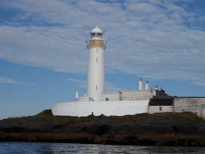
Lismore Lighthouse


Lismore Lighthouse was completed in 1833, and is a white tower 26 metres high carrying a light at an elevation of 31 metres. It flashes white every 10 seconds and has a range of 17 nautical miles.

The principal engineer for the light was Robert Stevenson of the famous "Lighthouse Stevensons" family. One of the Stevensons was the author Robert Louis Stevenson. In another literary connection, the first Principal Keeper of the light was a Mr Robert Selkirk, descendant of Alexander Selkirk who was the inspiration for Daniel Defoe's "Robinson Crusoe".

Viewed from the island, the lighthouse buildings are strikingly symmetrical. The keepers accommodation certainly didn't appear cramped, and there's a courtyard in front of the tower. Farther back across the small bridge are two fields enclosed by high drystone dykes, for either some vegetables or perhaps some livestock. Gardens in front of the main cottages still show some traces of flower beds.

The Northern Lighthouse Board are currently doing maintenance work at the light; the whitewash was positively shining in the morning sun.

Tuesday 13 April 2010

Eilean Musdile


First job of the day was to make the 7km crossing of the Firth of Lorn. This is an interesting and active stretch of water. The flood tide splits into three streams here, one stream goes up the Sound of Mull, the others go up up Loch Linnhe passing either side of Lismore. Conversely, the ebb streams meet here, with the stream in the main channel rotating gradually clockwise. I'd chosen a quiet time near slack water at the end of the ebb and so had a quiet crossing.

Part way across I was overtaken by the Calmac ferry "Isle of Mull" on her first run from Oban to Craignure. She's one of the bigger Calmac ships and carries 70 cars and 951 passengers. Her service speed is 15 kts so it pays to look over your shoulder on this crossing! Fortunately she announces her arrival and departure in Oban Bay on VHF so I could estimate when she'd pass me.


Arriving at Eilean Musdile I passed underneath Lismore lighthouse and looked for a landing spot. There are slipways either side of the lighthouse, but at low water they weren't useable. Even at this quiet state of the tide, swells were surging around the island.


Heading along the island I came to this bridge spanning a tidal passage - not quite a bridge over the Atlantic but impressive all the same.


At the north tip of Eilean Musdile I landed on weed covered rocks and walked back to explore the lighthouse. Looking north to Lismore, I spotted a likely campsite for the evening if I could manage the whole way around Lismore.


Monday 12 April 2010

Kerrera Camp


With a fine forecast, I headed off on a two night sea kayaking trip in the Loch Linnhe area. Arriving at Ganavan Bay just north of Oban at 6.30pm, the usual faff of initial packing seemed to take longer than usual, and it was 7.30pm when I got on the water.

Fortunately, the island of Kerrera where I planned my first camp was just 5km away! I found a good spot just as it was getting dark and set up the tent. It had taken longer to pack and then camp than it had to make the short paddle, but I was now ready for the following day.

And what a day. Early morning was beautifully calm and sunny and I had a great view to the Mull hills from my camp site.

I was soon on my way, paddling north west across a calm Firth of Lorn towards the south tip of the island of Lismore.

Tuesday 6 April 2010

Shieldaig


The final community on my trip was Shieldaig, sheltered in Loch Shieldaig. The name is from Old Norse Sild Vik "Herring Bay", though herring are no longer fished from here. It's a pretty village in a spectacular setting.


I enjoyed a pint of Black Cuillin ale outside the Tigh an Eilean Hotel
and enjoyed the pleasant afternoon sunshine. The ale was very nice, and it seems to me that the hotel is a great sea-kayaking pub, but it must await rating by the staff of seakayakphoto.com
in due course!


I was accompanied back to the shore by this fine chap; a Springer Spaniel with three legs. Despite a missing front leg, he can certainly get about, and was very keen to come with me either by swimming or by getting in the boat with me. He looked genuinely disappointed to be left behind...


I left the shelter of Loch Shieldaig and headed back along Upper Loch Torridon into a stiffening headwind. There were great views of the mountains - here Beinn Alligin from a different angle. The headwind increased rapidly to Force 5-6 and it became very difficult to make any progress. Eventually I got back to Torridon village, tired but very pleased with a great day paddle of 38km. All that remained was the four hour drive home...


Monday 5 April 2010

Lower Diabaig


The village seemed deserted. As I wandered along the short stretch of shore road, this motif painted on the front of a metal outbuilding caught my eye.


On the beach, a wrecked fishing boat lay near the high water mark. I could tell that it had originally had a blue hull and red bottom, and that the wheelhouse was steel.


It looks that someone has tried to burn the wreck in situ; scorched timbers surrounded the open bow. A photo on the Undiscovered Scotland website shows the boat in much better condition, and it looks to have had white upperworks and a covered fo'c'sle.


It doesn't look like a local boat, and the Scandinavian manufacturer's name on this tank lid next to the hull suggests it comes from across the North Sea.

Sadly, there was nobody around to ask. Lower Diabaig remained deserted, except for an elderly lady who wandered out onto the pier as I was leaving.

I rounded the southerly point of Diabaig Bay and headed south towards the final community I wanted to visit on this trip.

Friday 2 April 2010

Right Choice of Toys?


Today we went to the coast on a beautiful Good Friday. I had a really pleasant couple of hours rockhopping along my local paddle, Cullen to Portsoy on the Moray Firth.

But just two miles up the road from the house, I was wondering whether I'd brought the right toys; perhaps the XC skis might have been a better choice?!

Enfolded By Arms Of Naked Rock


Continuing to the the north west, a succession of rocky bluffs are passed. Ahead, Tom na Gruagaich of Beinn Alligin (Hill of the Maiden, Jewelled Mountain) was just clearing the cloud.


Around a final point, I entered Loch Diabaig. I have an out-of-print guidebook to the West Highlands written by the late W.H. (Bill) Murray, one of Scotland's great writers, in which he describes Loch Diabaig as "a mile long bay of outer Loch Torridon enfolded by arms of naked rock". It's a good description; no photograph I could take showed properly the setting of the village in it's sheltering rocky arms.


Bill Murray also wrote of the community itself; "On a coast where loveliness is met at every turn, Diabaig is remarkable".

I paddled into the shelter of a fine stone pier and landed on the beach to explore a little.