Good conditions might be expected on the lower hills though. Since day lengths were short I decided to climb some of hills closer to home - and where better to start than with the Correen Hills just a few minutes from the door....

I started out from the road which skirts the eastern side of the Correen Hills intending to take in the whole ridge then walk back to the house, giving me a nice starting height and a hillwalk which would have more descent than ascent. As a bit of a bonus, the low winter sun would be at my back for most of the walk.

After following the track for a few kilometres a faint path is taken up a narrow firebreak which leads out onto the open moor near the summit of Mire of Midgates. This point was also where I came out of the shelter of the forest and ridge into a chilling northerly wind - it would be a day better suited to fast movement than dawdling.

A trig point at 487 metres lines up with those on Tap o'Noth to the north (which I would visit a few days later) and the Buck o' the Cabrach to the west. Visibility was very good in the cold air, hampered only by the eye-watering experience of trying to look into the teeth of the wind!

At the opposite end of the Correen Hills, Lord Arthur's Hill is the termination and also the highest point of the broad horseshoe ridge. Each time I walk these hills the trick of perspective is the same, the distance between hills and around the whole ridge looks long, but the ground is covered in much less time than might be imagined.

High on Brux Hill (really just a faint rise in the ridge line) are three generations of boundary marker- a modern wire fence, an older straining post for a wire fence and a Victorian boundary stone - the "D" indicating (I think) Deskrie estate.
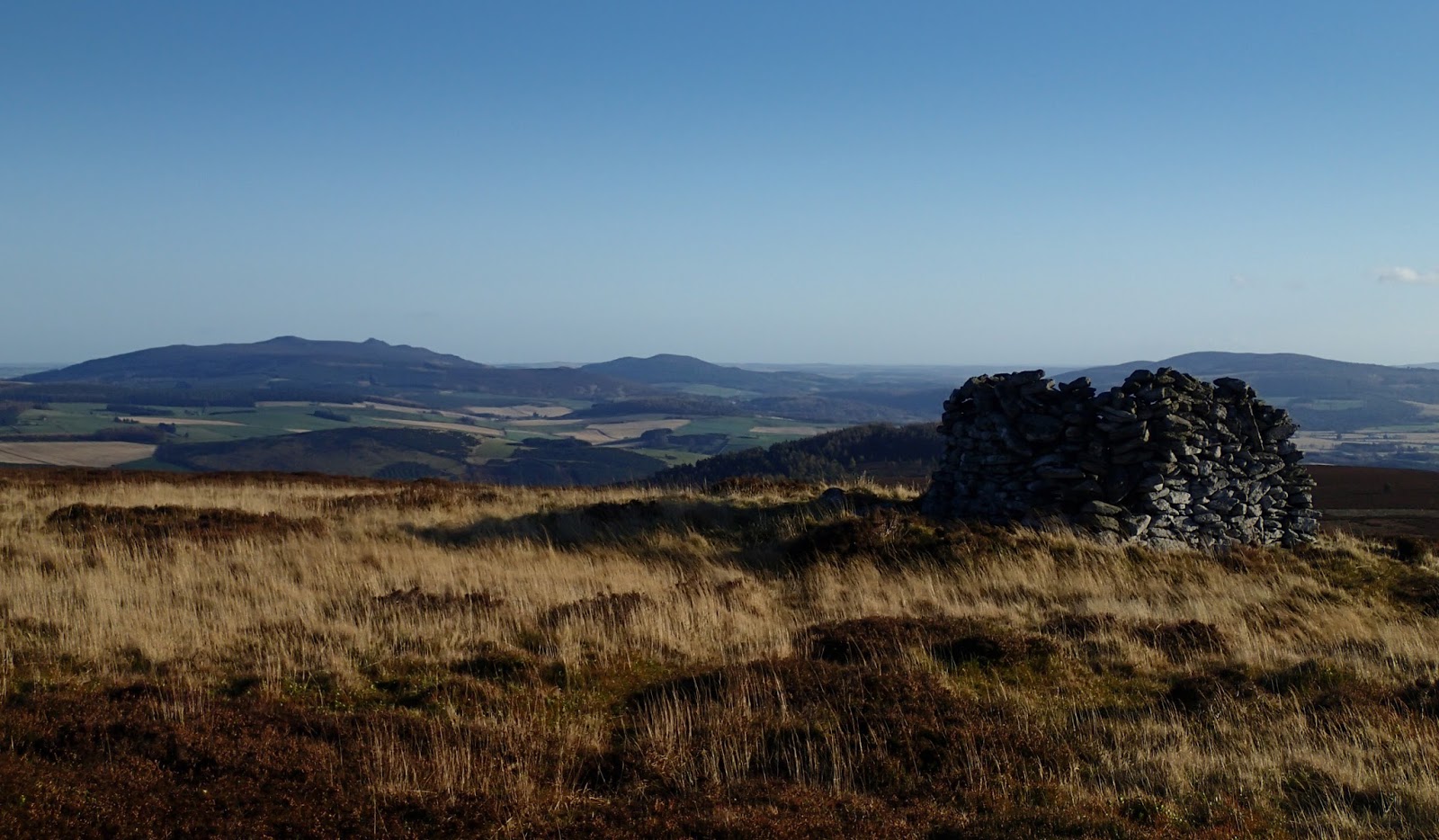
A couple of invigorating hours later I made the final pull onto Lord Arthur's Hill, at 518 metres/1699 feet a "Marilyn" - defined a British hill with at least 150 metres ascent all round, regardless of height. One of the features of Marilyns is that they tend to give a good view and this one is certainly no exception, this image looks past the large summit shelter cairn across the Howe of Alford to Bennachie.
The cairn is actually a circular shelter and I was glad to be able to hunker down out of the wind to take a brief stop. Luncheon was a spartan affair of fruit, nuts and a drink of water; enough to keep me moving towards a bowl of home made soup back at home a couple of kilometres away at the base of the hill :o)

As soon as I began my descent down the long spur of the Fouchie Shank I dropped out of the worst of the wind and into much calmer conditions. It pays to move quietly on this part of the walk, there are often close views of Roe Deer and on this occasion I was treated to the sight and sound of a flock of Bullfinches moving through the trees.
The track reaches the road near the small and inhabited castle of Terpersie and Dubston farm. If doing this walk as a circular route there's space for a couple of cars to park at the road-end where the farm access track starts.
The route described above is 14 kilometres and takes about 4-5 hours. The starting point has plenty of parking at the Gordon Way car park. I think that the Correen Hills are underrated, but since they're virtually on my doorstep, I may be a little biased!
I'm sure you're a little biased, Ian, but with good reason. Looks like a wonderful day, and such clear (albeit breezy) air. The brief luncheon break, in the spartan shelter of the cairn, would just whet the appetite for that soup. :) Warm wishes.
ReplyDeleteThanks Duncan, it's a luxury to be able to walk straight home from a summit! :o)
DeleteWarm wishes to you both
I've enjoyed most of the Marilyns as much as the Munros. Looked at the Correen Hills on the map and wondered what they were like so thanks for the views Ian. Might get up there someday with the petrol prices falling.
ReplyDeleteThe wee hills may lack height, but they always seem to pack a punch Bob! Let me know if you're heading up this way :o)
DeleteKind Regards